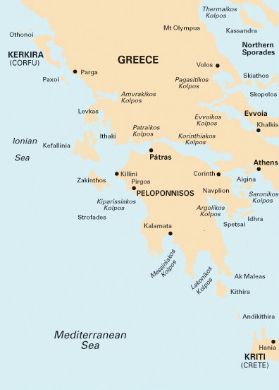
 G1 Mainland Greece and the Peloponnisos
This Imray Chart is a passage chart.
Plan Ormos Falirou
Scale 1:729,000

|
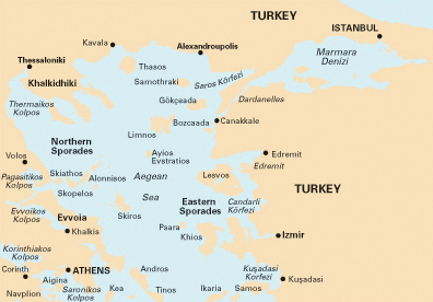 G2 Aegean Sea (North)
This Imray Chart is a passage chart.
Approaches to Istanbul,
Izmit Körfezi,
Çanakkale Bogazi (The Dardanelles)
Scale 1:750,000
|
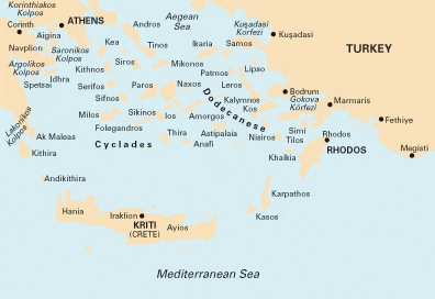 G3 Aegean Sea (South)
This Imray Chart is a passage chart.
Scale 1:750,000
|
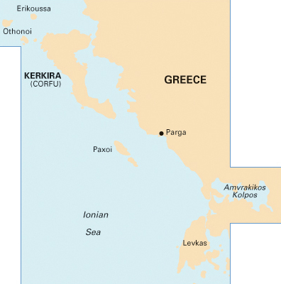 G11 North Ionian Islands
This Imray Chart covers Corfu to Lefkas, Paxos and mainland Greece.
Plans
Continuation of North Ionian Islands to Othoni island,
Vorion Steno Kerkiras,
Ormos Gouvion (Gouvia Marina),
Kerkira (Corfu Town),
Parga Bay,
Continuation of Amvrakikos Kolpos,
Limin Alipa (Kerkira),
Lakka Bay (Paxoi),
Port Gaios (Paxoi)
Scale 1:185,000
|
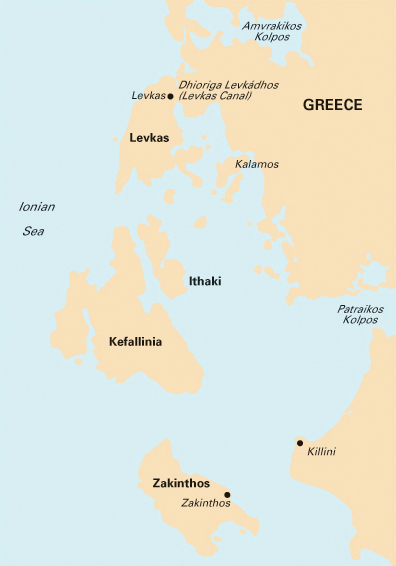 G12 South Ionian Islands
This Imray Chart covers Zakynthos, Kefalonia, Ithaka, north-east Peloponese (entrance Patras Gulf), mainland Greece.
Plans
Levkas Canal,
Kolpos Aetou (N. Ithaca),
Ormos Argostoliou (N. Kefallinia),
Zakynthos bay
Scale 1:190,000
|
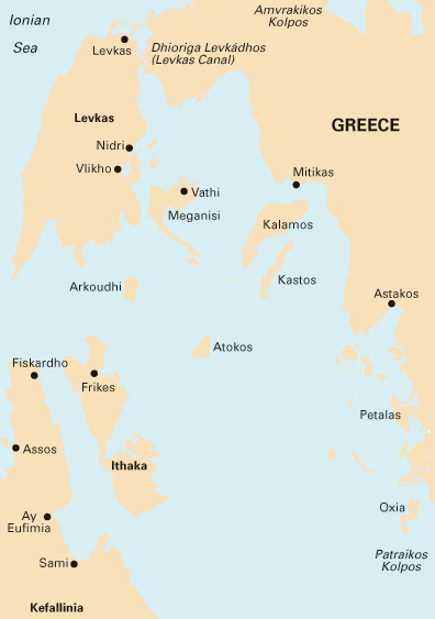 G121 Inland Sea
This Imray Chart covers the inland sea, Ionian: Lefkas, Meganisi, Ithaca, and part of the mainland and Kefalonia.
Plans
O. Ayias Eufimia (N. Kefalinia),
O. Frikou (N. Ithaca),
O. Fiskardo (N. Kefalinia),
Vasiliki (N. Levkas),
Levkas Canal,
Kalamos Harbour
Scale 1:95,000
|
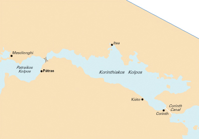 G13 Gulfs of Patras and Corinth
This Imray Chart covers the Gulf of Patras and the Gulf of Corinth.
Plans
Mesolongion,
Limenas Patron,
Rion - Antirion bridge,
Ormos Aiyiou,
Krissaios Kolpos,
Ormos Andikiron,
Kiato,
Ormos Loutrakiou,
Dhiorix Korinthou (Corinth Canal)
Scale 1:220,000
|
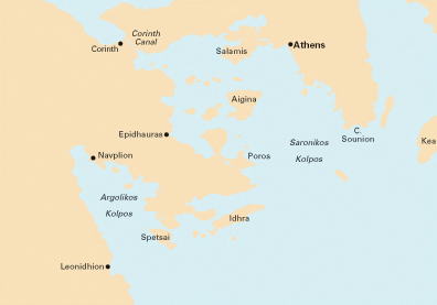 G14: Saronic and Argolic Gulfs
This Imray Chart covers Athens, the Argolic Gulf, the Saronic Gulf, Poros, Methana, Aegina, Salamis, Corinth Canal, Cape Sounion, Lavrion, Hydra, Spetses, Leonidion, Navplion, entrance of Corinth Gulf.
Plans
Ormos Falirou,
Marina Alimos (Kalamaki),
Limin Aigina,
Limin Porou,
Steno Spetsai,
Navplion
Scale 1:190,000
|
 G141: Saronikos Kolpos
This Imray Chart covers Athens and the Saronic Gulf, Poros, Methana, Aegina, Salamis, entrance of Corinth Canal, Cape Sounion.
Plan Ormos Falirou.
Scale 1:110,000
|
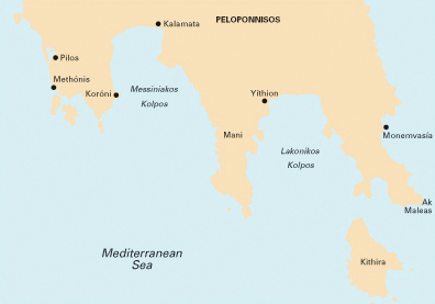 G15: Southern Peloponnisos
This Imray Chart covers the Ionian Sea - Southern Peloponese - Cape Malea - south Argolic Gulf to Monemvasia. Including Kithera island.
Plans Kalamata port, Ormos Navarinou, Yithion, Monemvasia, Ormos Methonis, Koroni.
Scale 1:190,000
|
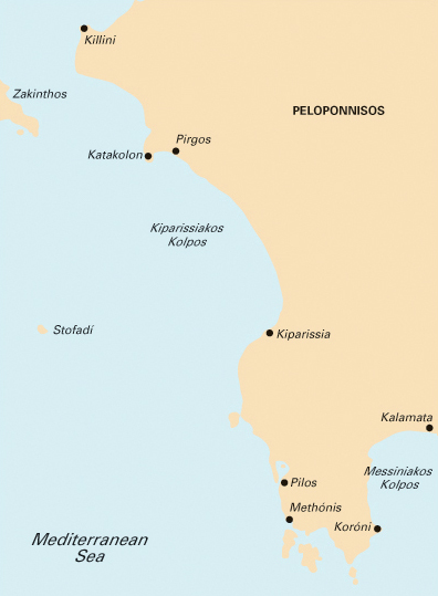 G16: Western Peloponnisos
This Imray Chart covers the Ionian Sea from Zakynthos till Kalamata on the western Peloponese.
Plans
Killini port,
Katakolon port,
Kiparisia bay,
Ormos Navarinou,
Steno Methonis,
Kalamata port
Scale 1:190,000
|
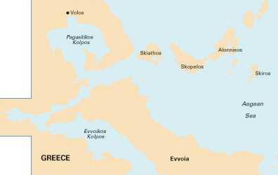 G25: Northern Sporades and Evvoia (Euboea)
This Imray Chart covers north Evvoia (Euboea) island and the Northern Sporades, Volos.
Plans
Ormos Skiathou (Skiathos),
Steno Alonnisou,
Linaria (Skiros),
Continuation of Maliakos Kolpos
Scale 1:190,000
|
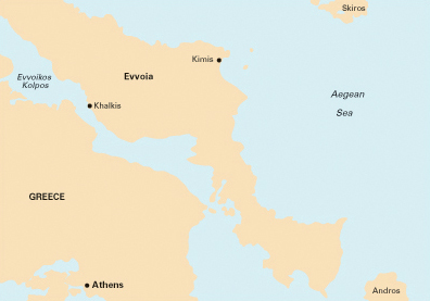 G26: Evvoia (Euboea)
This Imray Chart covers Evvoia (Euboea) island, south tip of Skyros (Northern Sporades) and the the north tip of Andros.
Plans Linaria (Nisos Skiros),
Kímis (Nisos Evvoia),
Approaches to Khalkis,
Erétria (Nisos Evvoia),
Limenas Aliveriou (Nísos Evvoia),
Rafina,
Porthmos Evripou,
Dhiavlos Steno
Scale 1:190,000
|
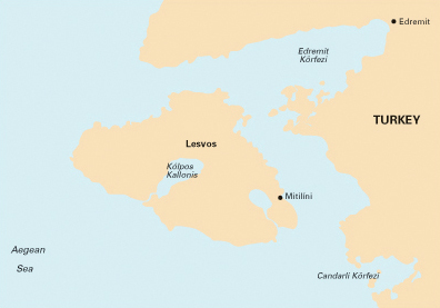 G27: Lesvos and Coast of Turkey
This Imray Chart covers the Lesbos (Lesvos) and the adjacent coast of Turkey.
Plans Ayvalik (Turkey),
Sigri (N. Lesvos),
Entrance to Kolpos Kallonis (N. Lesvos),
Entrance to Kolpos Yeras (N. Lesvos),
Mitilini (N. Lesvos),
Bademli Limani (Turkey)
Scale 1:190,000
|
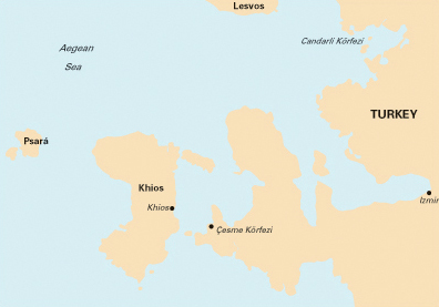 G28: Khios and Coast of Turkey
This Imray Chart covers the Eastern Sporades including Chios and Psara, the south tip of Lesbos (Lesvos) and the adjacent coast of Turkey and Izmir.
Plans Ormos Mandraki (N. Oinoussa), Approaches to Khios (Chios), Approaches to Psara (N. Psara), Cesme Korfezi (Turkey), Foca Limani (Turkey), Sigacik Limani (Turkey).
Scale 1:190,000
|
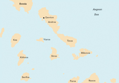 G31: Northern Cyclades
This Imray Chart covers the islands of Kea, Kythnos, Serifos, Siros, Andros, Tinos, Mykonos, Delos and the south tip of Evvia as well as the north tips of Paros and Naxos.
Plans O. Mikonou (N. Mikonos) O. Gavriou (N. Andros), Limin A. Nikolaou (Nisos Kea), Limin Sirou (N. Siros).
Scale 1:200,000
|
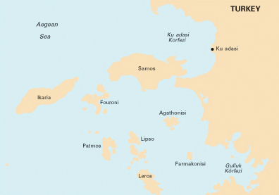 G32: Southern Sporades and the Coast of Turkey
This Imray chart covers the islands north of the Dodecanese: Samos (detailed chart of Pythagion marina, the main yacht charter base), Ikaria, Fournoi, Patmos, Lipso, Arki, Farmakonisi and Gaidharos (Agathonisi) plus part of Leros island and the adjacent Turkish Ionian coast stretching from Kusadasi to Gulluk.
Plans Kusadasi Liman (Turkey), Limin Karlovasi - N. Samos (Greece), Limin A. Kirikou - N. Ikaria (Greece), Steno Samou - N. Samos (Greece), Limin Pithagoriou - N. Samos (Greece), O. Patmou - N. Patmos (Greece)
Scale 1:189,700
|
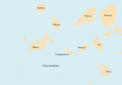 G33: Southern Cyclades (west sheet)
This Imray chart covers the islands of Serifos, Sifnos, Antiparos, Paros, Naxos, The little Cyclades (Karos, Iraklia, Skinoussa, etc), Ios, Santorini (Thira), Sikinos, Folegandros, Poliagos, Kimolos and Milos.
Plans Steno Kimolou (N. Kimolos), O. Livadhiou (N. Serifos), Steno Andiparou (N. Paros), O. Naxou (N. Naxos).
Scale 1:190,000
|
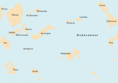 G34: Southern Cyclades (east sheet)
This Imray chart covers the islands of Naxos, The little Cyclades (Karos, Iraklia, Skinoussa, etc), Dhenoussa, Amorgos, Kinaros, Levitha, Leros, Kalymnos, (east tip of) Kos, Astypalaia, Anafi, Santorini (Thira) and Ios.
Plans O. Kalymnou (N. Kalimnos), O. Maltezana (N. Astipalaia)
Scale 1:200,000
|
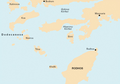 G35: Dodecanese and the Coast of Turkey
This Imray chart covers the Dodecanese islands of Leros, Kalymnos, Pserimos, Kos, Yiali, Nisyros and Tilos. Chalki plus north east part of Rhodes and Simi island. The Turkish Carian coast (Bodrum and Marmaris)
Plans Bodrum (Turkey), Rodhos - N. Rodhos (Greece), Kos & Kos Marina - N. Kos (Greece), Marmaris (Turkey), Limin Simi - N. Simi (Greece).
Scale 1:190,000
|
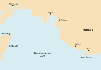 G36: Marmaris - Geyikova Adasi - Lycian Coast Turkey
This Imray chart covers the south coast of Turkey: from the north tip of Rhodes island and the adjacent Lycian coast of Turkey from Marmaris, via Gocek, Fethiye, Kalkan to Kas.
Plans Marmaris, Skopea Limani, Approaches to Meyisti and Kas, Rodos, Fethiye, Gocek
Scale 1:200,000
|
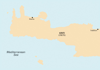 G37: Crete - West
This Imray chart covers the western part of Crete.
Plans
Kali Limenes,
Ormos Ay. Galinis,
Paleohora,
Gramvousa Bay,
Chania,
Souda Bay,
Rethimno
Scale 1:190,000
|
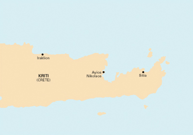 G38: Crete - East
This Imray chart covers the eastern part of Crete.
Plans
Iraklion,
Sitia,
Ayios Nikolaos,
Spinalonga
Scale 1:190,000
|
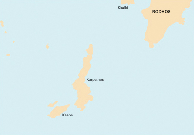 G39: Karpathos to Rhodes
This Imray chart covers the forgotten area south-east of Rhodes: Karpathos and Kasos islands.
Plans Ormos Pigadia (Karpathos), Lindos (Rhodes), Ormos Fri (Kasos), N. Khalki to N. Alimia.
Scale 1:190,000
|
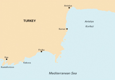 G40: Kas to Antalya, Turkey
This Imray chart covers the east Lycian coast of Turkey: Kas, Finike, Kemer, Antalya: Antalya korfezi and Kastellorizon.
Plans: Kekova Demiryeri , Kemer Marina , Finike , Antalya , Setur Antalya Marina , Approaches to Kas and Meyisti.
Scale 1:200,000
|
 Greek Waters Pilot
 Turkish Waters & Cyprus Pilot
 Ionian Pilot
 Turkish Cruising Companion
 Adriatic Pilot