Athens & Saronic sailing holidays
The Saronic gulf - Σαρωνικός κόλπος is due to its proximity to Athens - Αθήνα the focal point of yacht charters in Greece. Aside from the location, also the prolific ancient history attracts both tourists and sailors to these waters and shores.
Nearly all charter yachts are based at the marinas along the Attic peninsula (Attica) from where the majority of the yacht charter companies operate.
As a result of this concentration, many yachts follow identical itineraries in the Saronic/Argolic and converse at predictable times in Aegina, Poros, Hydra… To avoid these crowds, skip these for later and sail on (in front of the fleets) towards the east coast of the Peloponnese.
The western coast of the Saronic is mainly mountainous with a ridge running parallel to the shore (600 – 900 m). Higher up the land remains barren, but below densely wooded areas can be found.
- All Greek islands
- Argolic – Saronic overview
- Argolic gulf
- Spetses island
- Hydra gulf
- Poros island
- Aegina island
- Saronic gulf – Athens
- Alimos – Athens
- Sailing itineraries Argolic & Saronic gulfs
The normal summer winds depend heavily on where you are. During the summer the meltemi is the normal wind in this area. Along the mainland coast from the Corinth Canal to Cape Sounion as well as the area between Methana and the mainland (Attica) it will blow Force 4 – 6 at max., from NNE – NE. Near the mountainous west coast the wind will have a more northern component.
The winds are less strong near the Methana peninsula and Poros, whereas near Cape Sounion they might be stronger. Importantly, the meltemi blows with less regularity and less force than in the Cycladic islands.
Due to severe landslides the Corinth Canal will likely remain blocked till early 2022.
British Admiralty Chart 1657


British Admiralty Chart 1657 (1599 for Athens)
The Attic coast is mostly mountainous barren terrain, which holds 66% of the industrial activities of Greece especially around the island of Salamis and the harbour area of Piraeus.
Between Piraeus (Athens' ferry port) and Glyfada the coast is lined by high-rise apartment blocks; more than one third (at 3.75 million people) of the whole population of Greece (11.2 million) lives in Athens.
This modern architecture of Athens clashes with the ancient buildings and treasures. Until the first half of the 20th c. archaeologists were keen to demolish whole blocks of “new” houses to excavate the lower lying libraries, shops, streets, temples, etc. of ancient Athens. However, since the 1960's the local residents protested successfully against this wrecking of houses and streets, where they – and their parents before them – grew up.
Yet, there is a recent transition towards considerate excavations.
Ports and anchorages in the Saronic Gulf
Isthmus
The original Ancient World “Isthmus” was the landmark separating the Peloponnese from mainland Greece: the Isthmus of Corinth, now breached by the Corinth Canal, read on… →It is highly beneficial to draw a diagonal from the Corinth Canal to Cape Sounion across the Saronic Gulf, and to realize that most of the venues north-east of this division are industrial shipping facilities, unsightly marinas and (outskirts of) Athens.
With the notable exception of Alimos / Kalamaki marina, I therefore focus on the area south-west of this imaginary line. Also, there are dedicated pages for Aegina, Agistri and Poros islands.
From south → north → east, videlicet clockwise ↻
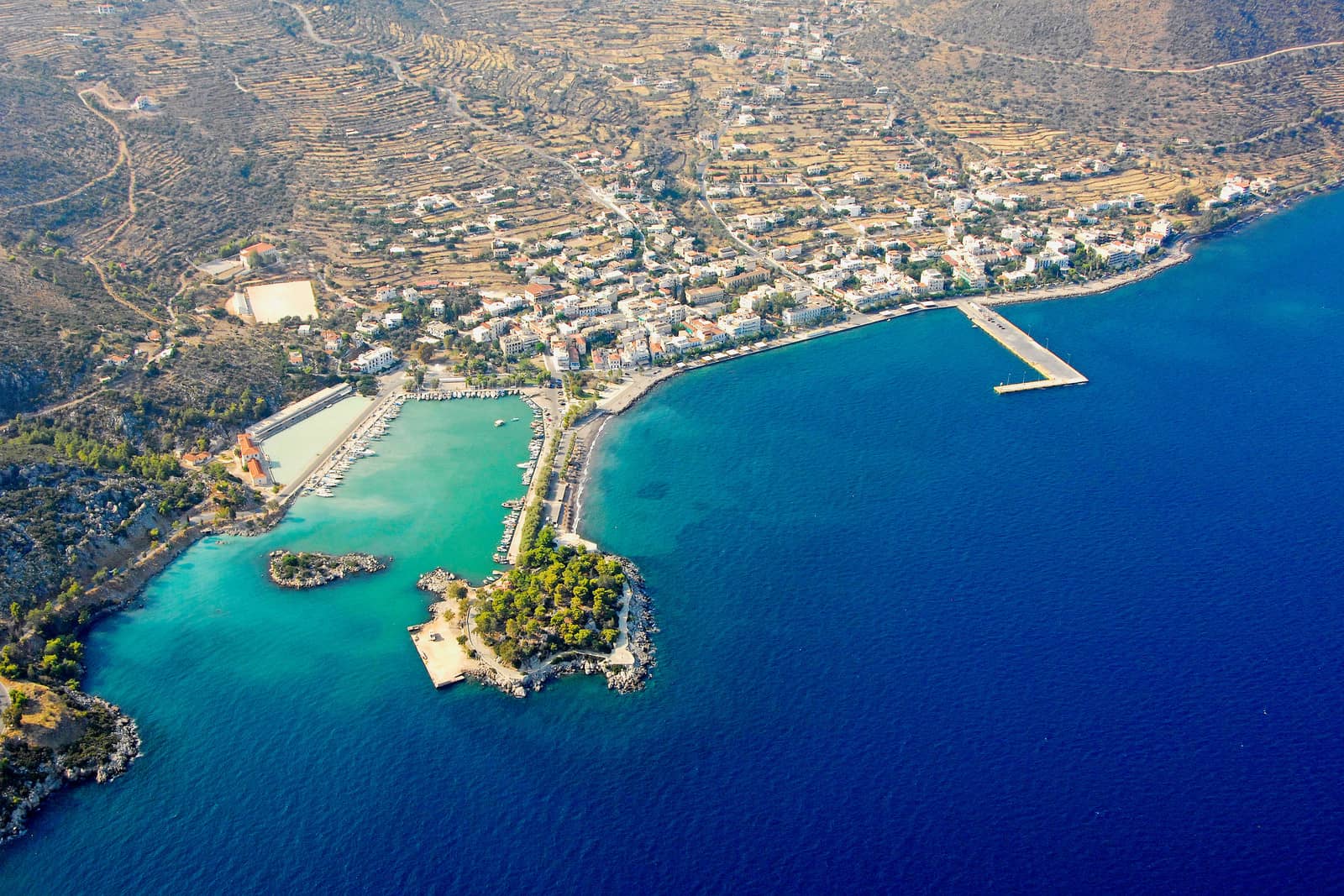
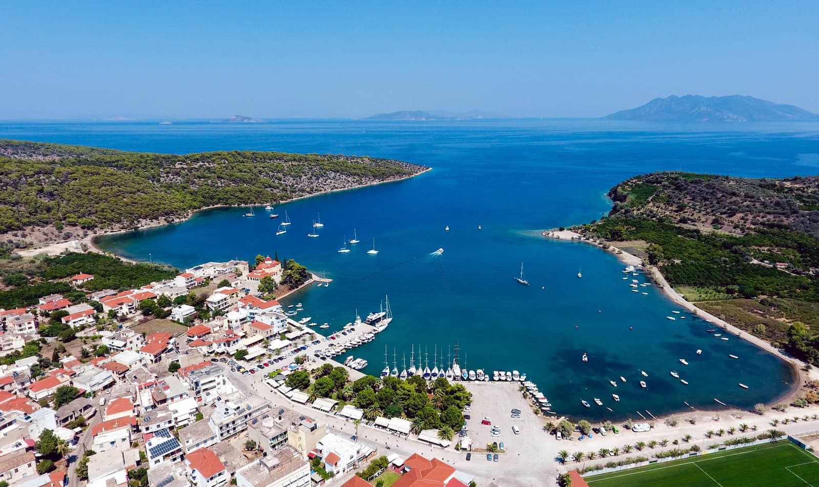
Methana
Marvellous mephitic Methana - Μέθανα is a volcanic peninsula – and former spa and modest seaside resort in a nice environment with two yacht harbours. You will be greeted by the pungent smell of its sulphur springs and solfataras

The old port to the west is typically filled with local yachts; the entrance is just 25 but soft mud; use the laid moorings; excellent shelter; to avoid metal corrosion, ropes are used.
At the recent completed ferry port go stern-to where indicated on the inside; ferries dock predominantly on the NE and SE sides of the L-shaped quay. You may be ordered to leave if a ferry intends to dock at the inside; open to southerlies.
A lovely restaurant, hidden a few blocks from the dock, is “To Steki”.
Foundations of a Mycenaean Sanctuary, 30 min walk to the north-east, follow the coast.
Just as in Loutra on Kythnos, the spa is closed, but you can still take a hot & malodorous bath outside the old port (west of the red light).
Ayios Georgios
On the north coast of Methana peninsula, the quiet village of Ag Georgios - Άγιος Γεώργιος has a shallow port suitable for smaller yachts and catamarans. The seabed inside the port rises quickly to become <1 m, stay within a couple of boat lengths of the mole. Leaving or entering the port in strong winds is dangerous; entrance has depths less than 3 m (C-MAP shows 25 and Eagleray shows 29); obstruction north-west of the red light.
Allround shelter except from >6 Bft northerlies; good holding, sand, weeds; the berths close to the red light are best (3 m); authentic fishing port with tavernas ashore.
Vathi
The wonderful fishing port of Vathi - Βαθύ, on the west coast of the peninsula, is ideal to escape most of the sailing community. Good protection against prevailing gusts from NNE – E; untenable in strong south-westerlies (rare during holiday season); mostly good holding in mud and weeds; it is possible to take a line ashore on the northwest side; “Jimmies Fish Taverna” at the waterfront is one of the best restaurants on the peninsula; also noteworthy is “Athina Meletis”.

The craters are best reached from this port, walk either towards Kameni Chora “burned village” or take the shortcut uphill, see hiking routes with map. There are dozens lava domes of various sizes, the highest peak being 740 m. The last volcanic eruptions occurred in 230 BCE destroying Kameni and in 1700 (a submarine eruption). In the near future another eruption is expected.
South of Vathi is the archaeological site of Paleokastro, with amazing views, where you can visit an acropolis built between 1500 and 1300 BCE, a golden age in the Mycenaean period. During the Peloponnesian War (431 – 404 BCE) the Athenians built a long wall to cut the peninsula off from the mainland, according to Thucydides. In Hellenistic times – after the reign of Alexander the Great – Methana fell under the rule of the Ptolemies, the kings of Egypt.
Kalloni
The brand-new port of Kalloni - Καλλονή sits in a fertile plain guarded by majestic mountains. Grand views; allround shelter; the port is not shown (or rather rudimentary) on C-MAP, Eagleray or Navionics Lat Long ; go stern-to near the green light; depths vary: 2 – 3 m ; several tavernas north and inland; limited provisions.
Finally… sigh, in the 2022-GWP this stunning venue is listed.
Taverna "Manthos" – the owners catch their own fish.
Most of my regular crew insist this is a port.
Palaia Epidavros
The charming harbour of Palaia Epidavros - Παλαιά Επίδαυρος is the gateway to the world-renowned amphitheatre, Sanctuary of Apollo Maleatas and Sanctuary of Asclepius – 20 min. by taxi – further inland.

Shelter in all but east winds, but these are very rare (except for mid-spring); sea levels can vary by over a meter; shallow bay, but the channel/approach is straightforward; good holding, ask the Harbour office for a berth.
The former anchorage at the north-west is now a designated swimming area, marked with buoys.
Restaurants: “Mike” (my favourite, right at the quay), “Ta Klimata” and “To Perivoli tis Gogos”.
In the pre-Greek period, the god of Maleas / Maleatas, whom the Greeks identified with Apollo, was worshipped above the theatre on Mount Cynortion. Apollo was joined by his son, Asclepius, who, according to legend, grew up in Trikka in Thessaly. Asclepius was taught the healing arts by the Centaur Chiron and was eventually able to bring the dead back to life. For this reason, Zeus killed him with a thunderbolt and his body was buried in Epidavros.
Competitions were held each every four years in honour of Asclepius. The cult began to spread through-out the ancient world at the end of the 5th c. BCE. The Romans began venerating the healing god in the 3rd c. BCE under the name Aesculapius. The increasing numbers of people seeking a cure led in the 4th and 3rd c. BCE to the development of the site at Epidauros. The priest-physicians used, among other things, a hot spring for their therapy and surgical instruments have also been found. In addition, sports – the stadium can be seen north of the carpark – and theatre performances were part of the therapy.
The Asclepius Sanctuary was closed during the reign of Emperor Theodosius I around 390 CE. Emperor Justinian erected a fortress on the ruins in the 6th century.
The remarkable well preserved theatre of Epidauros, which could seat up to 12 thousand people, is above all known for its acoustics – right up to the last tier 23 m above the orchestra.
The lower part up to the semi-circular gangway, divided into twelve sections by stairs, was built in the early 3rd c. BCE and the upper part followed in the 2nd c. BCE.
The core of the theatre is the circular orchestra and very little remained of the stage building. Ramps on either side led up to the roof of the proskenion, which was used as a raised area for the actors to perform on. The spectator entrances and the entrances for the chorus lead through magnificent gateways.

In the village of Ligourio – just north-west of the excavation site – is the beautiful 12th c. Church of Agios Ioannis Theologos, a two-columned, domed-crossing church, whose masonry shows a great deal of spolia
Also visit the local Natural History Museum.
8 km west of Ligourio, on the road to Nafplio, is an essential Mycenaean bridge (13th c. BCE).
Nea Epidavros
The peaceful port of Nea Epidavros - Νέα Επίδαυρος is undervalued by most sailors, yet provides shelter from all winds in an inviting setting.
There is a wreck in the north-east corner inside the port; prevailing NNE wind; good holding; some berths have laid moorings, a local official will guide you to your spot; yachts can moor on both sides of the west mole; friendly restaurant “Marilena” overlooking the port; adjacent are the local taxi stand and the “Marina Office”, which can arrange water & electricity. A fertile valley with orchards, surrounded by cliffs. The actual village is 2km west; taxi to the amphitheatre is ~25 min.

Selonta
Just south of Korfos is the narrow cove of Selonta or Selonda - Σελόντα. We counted about 47 circular fish farm nets, along the north side of the cove, containing e.g. Sea Bream / Dorade & Sea Bass, which obviously spoil the otherwise pleasent setting; anchor in >10 m in the NW corner Lat Long
Korfos
The bay and quay of Korfos - Κόρφος village are protected to all winds despite being open to the south. This fishing port – not to be confused with Korfos on Mykonos – has a modern naval history and was founded to ship resin extracted from the local pine forests in the late 1900s. The village has its charms, but is not spectacular, several worth-while churches in the area.
Good holding in sand and weeds; mind the rocks protruding from the oneven parts of the quay, keep the yacht well clear; two other sections of the quay (at the tavernas) have a finished edge and laid moorings; on the 60 m long jetty (home to several local charter yachts) go alongside or stern-to, depths 4 m; gusts from the north-west; patisserie-bakery, supermarket and taverna “Stavedo”.
Megalo Ammoni
The larger of the two Amoni bays is Megalo Ammoni - Μεγαλο Αμόνι, where – at the beach – you
you will find the superb fish restaurant “ΨΑΡΟΤΑΒΕΡΝΑ ΤΟ ΑΜΟΝΙ” ; nice surroundings; open to the ENE
Lat Long
South of Megalo Ammoni, two beaches (Kalogerolimano and Kiourkati) are suitable for lunch-stops in calm weather. The bays further south are snapped up by the fish farm industry.
Further reading: Greek chart terms.
Micro Ammoni / Dimani
The smaller Amoni bay is Micro Ammoni/Dimani - Μικρό Αμόνι, with very clear water, a short stretch of beach; a short walk to the taverna in Megalo Amoni; open to the NNE; anchor behind the protruding headland Lat Long
Fragkolimano
The lovely Fragkolimano - Φραγκολιμανο cove offers allround shelter in the east corner; anchor close to the shoreline, considerable depths, and take a line ashore; seabed is rocks, sand, weed; a scattering of generic white blocky holiday apartments, a beach and a restaurant with mixed reviews Lat Long
Agioi Theodori, Corinth
5 NM east of the Corinth Canal is a new shipyard Agioi Theodori • Almira for winter storage on land: hoisting and onshore facilities only → no wet berths.
Lat Long
Diaporia islets
The Diaporia / Dhiaporia - Νήσοι Διαπόριοι is a constellation of uninhabited islets, notably: Ledou, Tragonidi, Agios Ioannis, Agios Thomas, Moladi…
There are 5 anchor options:
- South of Moladi in 4 m; bottom is sand; useful shelter against Meltemi Lat Long
- Northern bay of Ag Thomas; open to northerlies; sand, weed, rocks Lat Long
- Eastern bay of Ag Thomas; offers only protection against north-westerlies; mostly sand Lat Long
- Southern bay of Ag Thomas; ideal in W – SE winds; sand, rocks Lat Long
- Ledou islet ; brilliant natural (shallow) harbour; snorkeling Lat Long alternatively, you can anchor outside (to the west of) the “harbour”, or indeed all around the isle; fish farm at the north side.
Recommended to use a tripline in all these anchorages, and to take a line ashore.
See chart symbols for the difference between  and
and  and my guide to Mediterranean mooring and anchoring.
The shallow channel between Ay Ioannis and Ag Thomas has a minimal depth of 3 – 4 m according to GWP and 59 m according to Eagleray and Navionics, whereas C-Map shows no hazards also keep a wide berth to the east and west sides of Moladi isle.
Fish farms at Ag Ioannis, Prassou and Ledou.
The island of Ypsilli, further east, is appearantly overrun with (giant) rats, therefore do not take a line ashore Lat Long
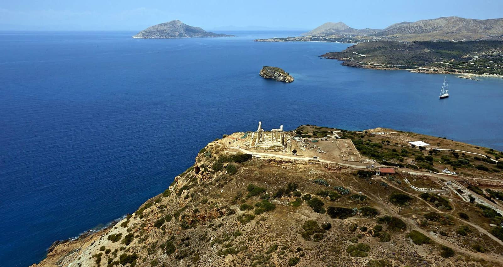
Cape Sounion
Cape Sounion - Aκρωτήριο Σούνιο, at the south tip of Attica, is famed for the majestic situation of its Temple of Poseidon perched on the edge of a precipitous crag.
The anchorages in the bay below the temple are used since ancient times to wait for the (Meltemi) storms to die and for modern yachtspersons to return to Athens / Alimos marina or proceed to Kea, Kythnos or Andros. The seabed is sand and weed, at times poor holding and taking a line ashore can be useful; gusts are from the north; tavernas nearby, but the 20 min. walk to “Syrtaki” is well worth it.
- North-west anchorage Lat Long
- North-east anchorage Lat Long
- East anchorage Lat Long
- Archi anchorage in southerly winds Lat Long
In strong southerlies: 24 NM → Korissia & Vourkari, Kea.
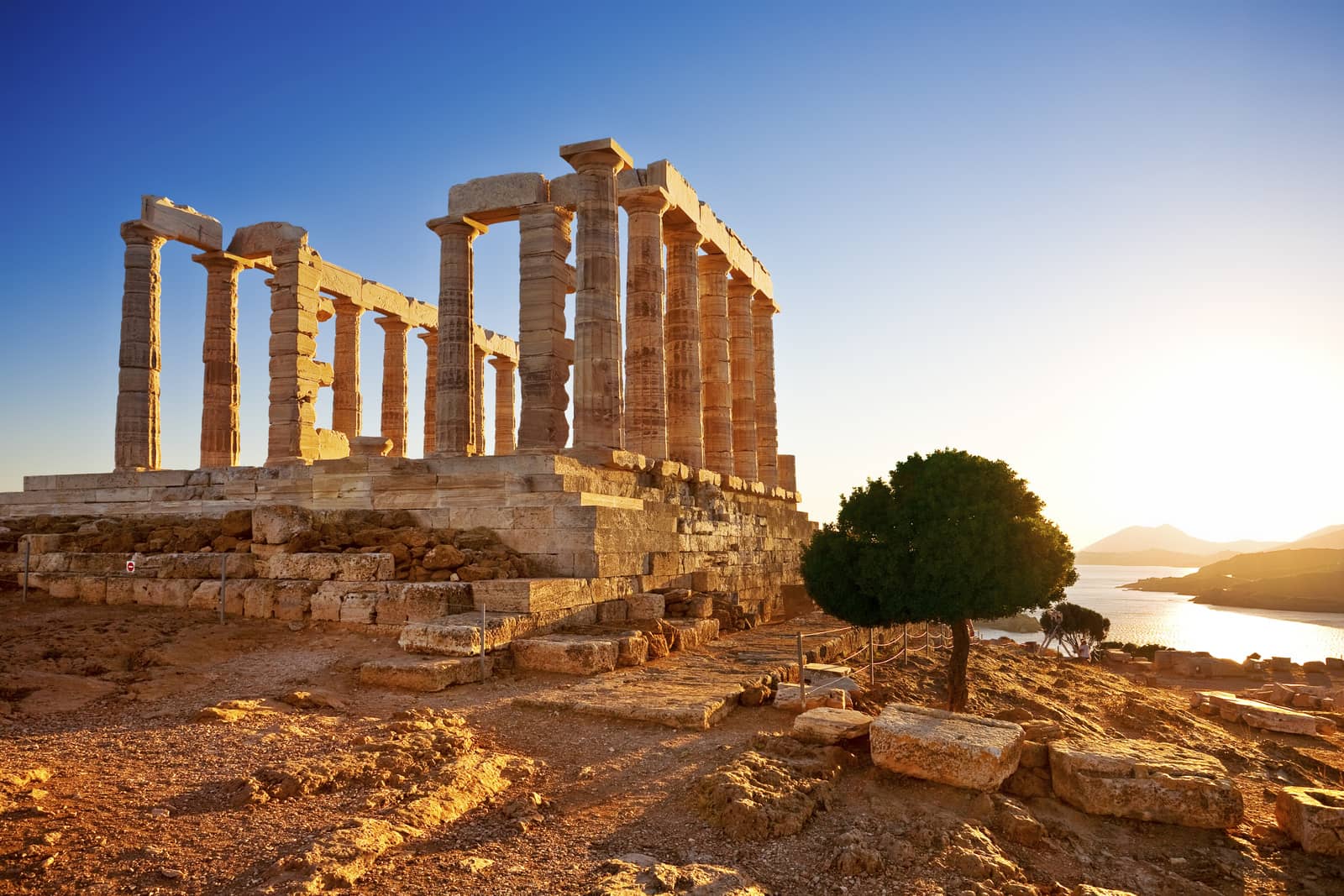
Homer refers in the “Odyssey III, 276” to the “holy Sounium, the cape of Athens”. In the 7th c. BCE there was probably a simple altar here; about 600 BCE the large kouroi one example is known as the Sounion Kouros, now in the National Archaeological Museum in Athens – were set up beside it; and around 500 BCE work began on the construction of a temple in poros limestone that was still unfinished when the Persians destroyed it in 480 BCE.
On the substructure of the earlier temple ruined by the Persians, possibly the very architect responsible for the Temple of Hephaestus in Athens erected in 449 BCE the present marble Temple of Poseidon, with 6 by 13 exceptionally slender Doric columns. It stands on a terrace, artificially enlarged, to which a propylon gave access. In the bay below were boathouses, some remains of which can still be seen.

The Temple of Poseidon, the village and the boat houses (neosoikoi) on the right.
On the left the port (what is now the beach) and just above is the Temple of Athena. Hi-res image
On a flat-topped hill 300 m north-east of the temple is a Sanctuary of Athena of the 6th c. BCE. Beside a small building measuring only 5 m by 7 m – of which the lower courses of the walls and the base of a cult statue are preserved – are the foundations of a similar but larger temple 11,5 m by 16,5 m, with the base of a cult statue. The roof was borne on four columns, in the fashion of a Mycenaean megaron. After suffering damages during the Persian wars the temple was rebuilt with two colonnades, not at the east and west ends as was the normal arrangement but at the east end and along the south side. The reasons for this departure are unknown. The temple of Athena was demolished in the 1st century CE, and parts of its columns were taken to Athens to be used in the south-east temple of the Agora.
Fragments of fortifications can be seen with some sections still eight blocks high.The first walls were probably built in the 6th c. BCE and strengthened, as reported by Thucydides in 412 BCE because of the Peloponnesian War to ensure the movement of the Athenian ships, especially those carrying wheat. Repairs and additions to the walls happened during the Chremonidean War (266 – 229 BCE).