Rain & clouds
Forecast showers
There are three tell-tales signs to visually discern a difference between a fair weather cumulus and a rain bearing cumulonimbus cloud, allowing you to forecast showers
1
A deepening (i.e. growing taller) cumulus signals the onset of showers.So, check whether the distance from base to top larger is than the distance between the earth's surface and the base.
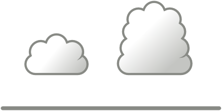
The cloud on the right spells rain, the one on the left is harmless.
2
A solid, preferably top heavy cloud is much more likely to produce rain than a chimney cloud. So, check whether the top is as wide as the base.
The cloud on the right spells rain, the one on the left is harmless.
3
A pileus (Latin: “cap” is an eyebrow shaped cap over the top of a developing rain cloud. Eventually, the ascending cloud overtakes the icy pileus formations and leaves these behind. In general: clouds that generate pilei are those most likely to develop into full-blown cumulonimbus clouds.See pilei examples.
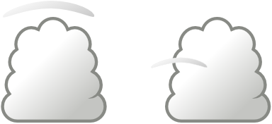
Both clouds bring rain and quite possibly severe weather as these caps indicate strong updrafts within the clouds.
Petrichor
The pleasant pungence of the air after it started raining is called “petrichor”.It comes – like so many beautiful words do – from ancient Greek: a combination of ichor ἰχώρ, the ethereal golden essence the Greeks believed flowed through the veins of their gods, and petros πέτρος, the stones that form the surface of the earth.
Especially during long periods of drought decomposed organic materials are blown airborn from dry soil landing on dirt and rock where it reacts with minerals, producing potent petrichor molecules. In fact without rain these molecules remain in the soil and signal plants to prefend roots from growing and seeds from sprouting.
The first bouncing raindrops will bring lovely smells upwards, and the absence of petrichor molecules in the soil will signal plants to start growing and flowering and seeds to start sprouting.
Geosmin
One noteworthy and ubiquitous petrichor molecule is geosmin, a metabolic by-product of bacteria and blue-green algae. Its name is again derived from ancient Greek: a combination of “earth” γεω and “smell” (noun) ὀσμή.
Camels will home in on geosmin to find an oasis and the bacteria will then see their spores delivered elsewhere. But also our own human nose is extremely sensitive to geosmin and is able to detect it at concentrations as low as 5 parts per trillion. If fish, wine or vegetables (notably beets) are too strongly flavoured with geosmin, then boiling or acidity (vinegar, tomatoes, citrus fruits) will easily break this muddy taste down to pleasant levels.
The petrichor smell of summer rain brings us positive associations, such as fertility and kisses.
Ozone
Already before a thunderstorm arrives we can smell ozone O₃ because lightning splits oxygen molecules O₂ into oxygen atoms which subsequently react with oxygen molecules to form ozone.
The name ozone derives from ozein ὄζειν, the ancient Greek word for smell (verb), referring to ozone's distinctive smell.
Further insights
- It is easy to tell the difference between ice and liquid in a cloud, because liquid has a very sharp cloud edge, yet ice has a diffuse and fuzzy cloud edge
- Virga is the meteorological term for rain, snow or ice crystals visibly falling from a cloud in a streak, without reaching the ground due to evaporation. Virga examples.
- A cloud that starts to rain will affect the wind we sail in. Rain cools the air underneath the cloud through evaporation as it collects heat (similar to perspiration), resulting in a downwash of colder air. Expect gusts and a new wind direction which is a combination of the original wind direction and the cloud's direction. A big cumulonimbus will actually take over the local wind regime.
- Rain most often starts off as snow so an high rising cloud is necessary to reach the colder altitudes. Hence the icy pilei and the height of the cumulus are good indications if showers are imminent.
Related pages
Rain isn't teardrop shapedMeltemi forecasting
Wind chill