Kalymnos & Leros sailing holidays
Kalymnos - Κάλυμνος is a bare limestone island, slashed by numerous gorges, lying 6 NM to the North-West of Kos island, adjacent to Pserimos island, and separated from Leros island by the Leros Strait or Stenon Lerou.
The coasts are mostly steep and rocky, with numerous coves and inlets ideal for a sailing holiday.
The inhabitants live partly by farming in the few fertile valleys, but mainly by fishing for sponges in the South-Eastern Mediterranean sea and processing them for export to the USA. The departure (April – May) and return (Sept – Oct) of the sponge-fishing fleet are celebrated with lively festivities.
- All Greek islands
- Dodecanese • Southern Sporades overview
- Chios
- Samos
- Patmos • Arki • Lipso
- Leros • Kalymnos
- Kos • Nisyros • Tilos
- Astypalaia
- Symi
- Rhodes
- Itineraries in the Dodecanese, adjacent Turquoise coasts and Southern Sporades.
History of Kalymnos
Finds in various caves round the coasts, particularly at Daskalio near Vathy port and Ag Varvara, show that Kalymnos has been continuously inhabited since the Neolithic period. The island never played a prominent role in history.
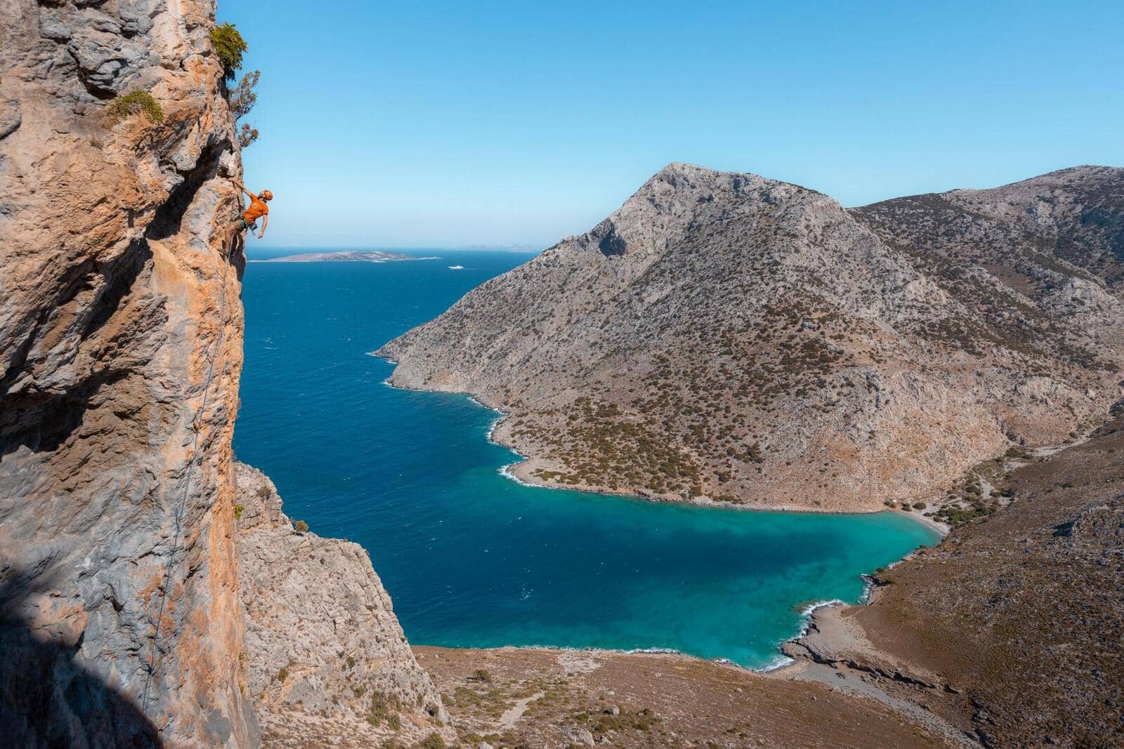
Climbing
Kalimnos is highly renowned for its rock climbing culture with many interesting routes, see Climbing Kalymnos and other climbing routes. To combine this with a yacht charter holiday best to use Kos or Bodrum as starting base.
Previous island: Patmos ↑

Approximate and disputed borderline coordinates between Turkey and Greece:
1 37° 07.827' N 27° 10.000' E
2 37° 00.183' N 27° 10.000' E
Next islands: Kos and Nisyros ↓
Leros
The island of Leros - Λέρος is hilly and fertile with an abundance of water and a much-indented coast. The inhabitants live by farming and fishing.
History of Leros
Leros was in ancient times dependant on Miletus. Although continuously inhabited since then, it has never played a part of any importance in history either. In the 4th c. the Knights of St John established themselves on the island and held it against the Turks until the 16th c.
In recent years it has had a rather mixed fate: for many years a leper colony, it was a German naval base during the Second World War, a re-education centre for the children of Communist partisans from 1947 onwards, a notorious psychiatric institution from 1957 onwards and a concentration camp for opponents of the military dictatorship from 1967 to 1974.
In the North, a section of Partheni bay is still a closed military area.
British Admiralty Charts 1056, 1531
Kalymnos island
Clockwise ↻
Pserimos island
Anticlockwise ↺
Leros island
Clockwise ↻
Chart Leros – Kalymnos – Pserimos

|
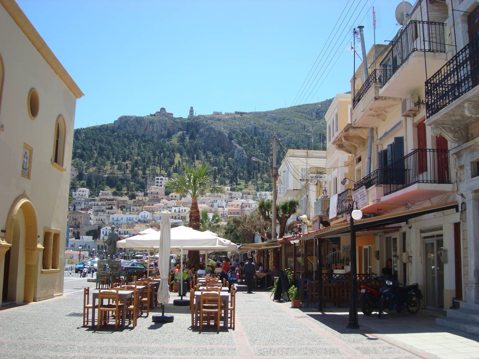
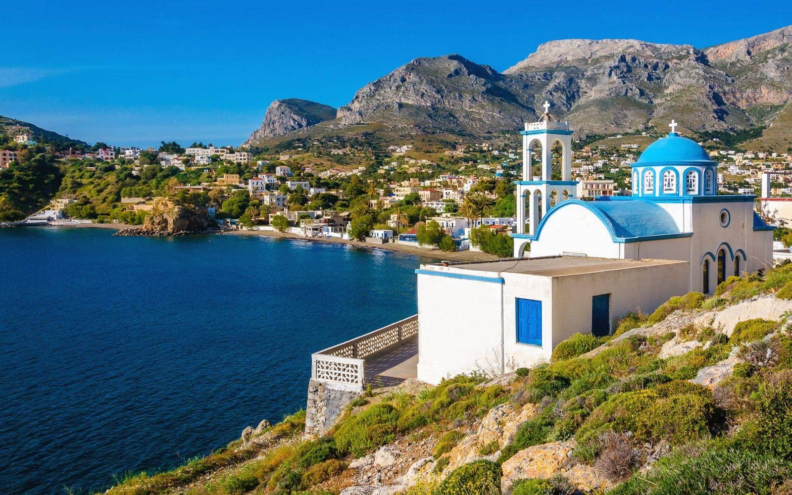
Kalymnos island
Kalimnos Port
Kalimnos port, Kalymnos port, Limin Kalimnou - Κάλυμνος or
Pothia - Πόθια
is located in the South of Kalymnos island and from the sea the town, the Monastery on the hill and the shining cupola of the Cathedral can be seen.
From a distance the town has a colourful Italianate feel, but closer in it shows that not every quarter is picture perfect. Not surprising with over 12 thousand inhabitants – compare the over 19 thousand for Kos town – plus the petro-industry.
The port offers allround protection when moored in the NE corner, where there is a Greek version of a down-styled marina, although SE – S winds can bring in a dangerous swell.
Moreover, there can be violent gusts from WNW (through the valley) and N; mediocre holding in mud and weed; go stern-to and use lots of chain. Normally though, only your aft mooring lines are tested.

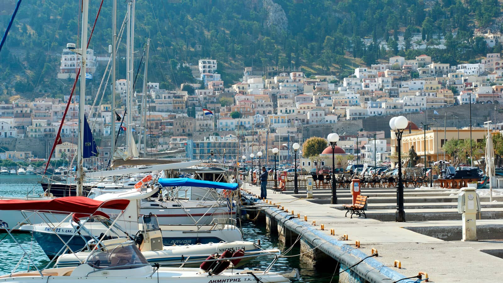
When you arrive you will be assisted with mooring, and you can arrange for electricity and water right away; berths costs 10 – 15 euros per night.
Tip this harbour attendant: several reports of a fraudster trying to sell you electricity and water, so only work with the official berth person in a yellow jacket; close hatches and raise the gangway to avoid theft.
The electricity and water pillars are far apart; the Harbour Master, Giannis, will be able to provide the usual nautical assistance +30 6944816743 as well as extension cords or hoses; Harbour Office +30 6973690761; water is drinkable, although off and on a bit brackish; ferries and larger tripper boats create a wash, keep the yacht well away from the quay, also because of protuding ballasting.
Eagleray shows an outdated chartlet without those peculiar concrete docks.
In the SW corner there is a second option (apparently only outside the season), but the typical direction of gusts means that your anchor should hold well.
Melpomene
She is a daughter of Zeus and Mnemosyne and was originally the Muse of Chorus, but she is now seen as the Muse of Tragedy… →The town, its handsome houses, in the neo-classical style popular in the islands in the 19th c., rises above the harbour on the gentle slopes fringing the bay. North-West of the town is the former capital of the island, Chorio (17th c.), with a byzantine castle. Halfway between these towns stands the Frankish stronghold of Pera Kastro or Chrysocheria Castle.
West of Chorio the ruined Church of Christ of Jerusalem can be seen, which is an Early Christian Basilica (6th c.) built – with spoliation of ancient stones – on the foundations of a Sanctuary of Delian Apollo: see Myrties port.
Visit the Marine museum and the Archaeological Museum (artefacts from the Sanctuary).
Grand views from St Savvas the New the Kalymnian Monastery; read about Saint Savvas the New of Kalymnos.
The Kastro Choras is equally worth the climb.
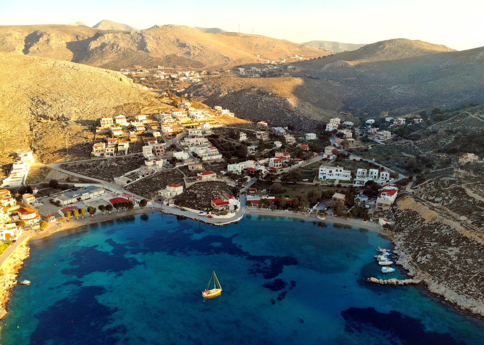
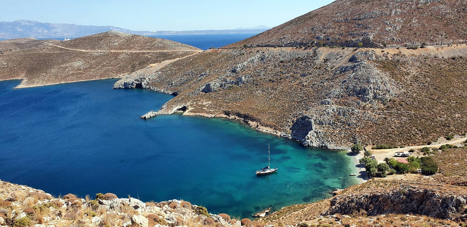
Vlychadia
The nearly enclosed and small bay of Vlychadia - Βλυχάδια has a narrow entrance to the South and offers an attractive anchorage for about 3 yachts.
Although it is possible to take a line to the stony breakwater [depths < 1.5 m], this is not practical in the prevailing Northerlies or Westerlies: instead anchor in the middle in 4 – 6 m, close to the beach. Lat Long
The hard sandy seabed is difficult to penetrate, yet when your anchor catches this is a very secluded anchorage; solely exposed to Southerlies; gusts are from the NW – NE, but are relatively mild at the head of the bay. Near the entrance (Meltemi) winds can funnel (typically NW) and become more problematic.
Increasingly, fast ferries in the Kos – Kalymnos strait can create rolling conditions inside Vlychadia bay.
The (half-sunken) buoys – pointed out by Eagleray, Navionics, Imray – have long been removed.
Beach guests are attracted by the crystal clear waters and pleasant surroundings.
Visit the “Nautica by Valsamidis” restaurant – which belongs to Yiannis – with around the back his fascinating “Sea World” museum: he will gladly be your tour guide. The collection started 50 years ago with papa Valsamidis, also a diver.
Furthermore, there is the St Kyprianos Monastery directly West, either cross-country around the bluff [ill adviced] or 45 min via the roads [much more sensible]. If you've made it to the gate, there is a second larger monastery: St Catherina, a 15 min walk NW.
Melitsachas • Myrties
Melitsachas - Μελιτσάχας and Myrties - Μυρτιές are the Kalymnos' fishing and ferry harbours, respectively, facing the port of Telendos and set in a lovely bay below the wooded hills and village of Masouri.
- Melitsachas is a fishing harbour Lat Long normally brimful with fishing boats, but the fishermen are very hospitable: ask for a berth.
Solid holding in sand, but preferably go alongside near the entrance; allround protection; sufficient berths with >2,5 m depths.
Ashore is the seafood dream of “Anna's Tavern” (Psarokatastasi).
Visit the Sanctuary of Delion Apollo, 10 min. by taxi. - No-go Myrties harbour is an exposed pier reserved for local shipping; only suitable in very calm weather and for a brief period since the water taxis & tripper boats return from Telendos every half hour.
The Southern low-lying tip of Telendos islet visible top right, and isle of Ay Kyriaki in the distance.
The Panormos bay lunch-stop anchorage is around the cape to the South.
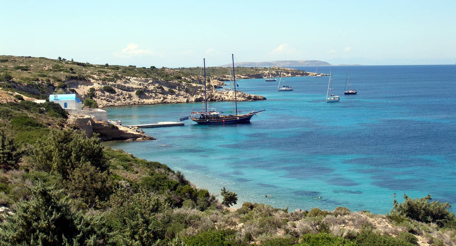
Telendos islet
The photogenic islet of Telendos - Τέλενδος is well worth a visit, but its Potha - Πόθα port is rather unequipped for keel yachts or even catamarans.
With only a few dozen inhabitants and no cars, the towering islet is an ideal nature reserve: e.g. for the endangered lesser kestrel (Falco naumanni), a smart looking species of falcon.
Three ways to explore Telendos by yacht:
- Anchor in 6 – 11 m over an area of sand, Lat Long the weed fields have however grown and there is little sand left to properly anchor: a lunch-stop anchorage.
Open to NW – SW i.e. there is only protection against Westerlies and partly against Meltemi (NW).
- Moor at one of the 3 orange buoys placed for visiting yachts; no fees; the buoys were pro tempore removed in 2021 and reportedly replaced in 2022.
- Take a line to the nearby concrete pier with the wooden extension, in front of “To Kapsouli” taverna. However, the wooden outer segment was destroyed in 2018 and has yet to be repaired. A second pier with a floating wooden extension, in front of the Early Christian Baths ruins and “Drop Anchor” & “Plaka“ tavernas, could serve as a substitute.
Anywhere else (shoreline or piers) is too shallow, even for multihulls, to approach.
Contact water taxi Captain Theophilis Pavlos tel: 6974 329670 for local assistence.
The quay can be noisy with tourists arriving from or returning to Myrties.
Telendos was recently connected to Kalymnos, becoming separated from it in the 6th c. CE following a series of earthquakes lasting 2 weeks: this last part might well be an urban legend.
There is no doubt that the infamous earthquake of 554 CE was especially powerful; the destruction it caused was felt in Constantinople, and is evident on the coast of Asia Minor and in many of the neighbouring islands, notably Kos. The seismic shocks are said to have continued intermittently for two weeks.
Caveat: earthquakes, unlike volcanic eruptions, only rarely cause large-scale land-subsidence.
It is therefore far more likely that both the acute effects of the earthquake as well as the chronic effects of slow subsidence over the centuries, have caused the shoreline to advance several dozen metres inland over what was a low lying and inhabited area that ringed the island.
Also note that the GWP erroneously indicates the “15th century” as date of separation.
The submerged settlements in the strait between Kalymnos and Telendos are thought to be the ancient capital Pothia or Potha, not to be confused with the modern capital and port Pothia.
A few submerged ruins are visible right on the coast of Telendos, while extensive posidonia meadows – including at the current anchorage – cover the rest of the sunken city.
Detailed history of Kalymnos & Telendos [PDF].
On Telendos visit the Early Christian baths.
Hiking shoes are essential to explore the other archeaological sites: on Mt Ay Konstantinos stands a medieval castle and at the foot of the hill is a ruined Monastery: the views are magnificent, the sites less so.
Lastly, there are plenty of fine tavernas.
South of Telendos is Panormos bay, a lunch-stop anchorage; very exposed and therefore rarely used; many ancient remains around this bay.
Argano (Arginonda, Arginonta)
More or less No-go Argano - Άργανο bay and the beach of Arginonda - Αργινώντα is rarely useable and hence off the beaten track. Anchoring is difficult because of the inescapable thick weed carpet, which extends right up to the shallow edges of the bay. It might look as sufficiently sheltered except for NW, but a swell will enter and most winds will find a way to funnel into the bay with mighty force: only suitable in calm weather. Lat Long
The valley is enjoyable and so are the tavernas, particularly “Katarina”. A road conspicuously scars the bay's coastline; a sheer cliff on the North side attracts climbers.
Its place name is supposedly derived from the Ancient Greek - ὄργανον meaning an “instrument, tool“, suggesting that there was at one time a hoist or winch present.
The marine farm – still shown on publications such as Imray and Navionics – was removed a decade ago. Interestingly, Eagleray adds: ‘precisely that location was known as “Karavostasi” - Καραβοστάσης (a ship stop), since with a line ashore there is allround protection.’
Compare Folegandros – Karavostasi(s).
Emporios
The village and bay Emporio - Εμπορειό or
Emporios - Εμπορειός is the most attractive and convenient venue on the West coast of Kalimnos island.
The toponym “Emporio” suggests a history as a trading place.
The village is guarded by Kalavros - Καλαβρός islet, which no longer (2014) has the fish farm still shown on most charts.
Emporios' 1st favourable feature is the 18 reliable mooring buoys, although some are a bit too closely spaced.
Most are owned by the Captain Kostas taverna where the granddaughter is now in charge. Recently also the Dreamcatcher restaurant has placed a number of buoys.
Note that there is no need to reserve; no fee for using and even when some red or blue buoys have restaurant names on them, there is no obligation to dine at that specific establishment; a swell can penetrate inducing rolling; a handy disembarkation pier for the dinghy is located near Kostas; gusts are North.
When the buoys are taken out for (winter) check-up, you will find that anchoring is unpropitious due to depths, hard sand and weed.

Its 2nd favourable feature is the abundance of natural beauty, with mountainous seascapes and a pod of striped dolphins Stenella coeruleoalba who almost daily patrol the bay and wider area: perhaps attracted by the single remaining fish farm. In addition, a duo of young curious males are eager to ride your bow waves. Finally, Harrys Paradise [check opening hours] is an almost exotic garden restaurant with colourful flowers.
Adjacent Emporios village:
- Elini's beach is a lunch-stop anchorage under the isthmus on the West side. Lat Long where the fish farm is gone although still shown on several charts e.g. Navionics.
- On the East side, in the “Pirates bay” – a bar and a restaurant with an over the top pirate theme – there are 3+ large and small buoys available, although one of these is set in very shallow water. The seabed here is a thick carpet of weed and doesn't allow an overnight anchorage.
The ruined ancient fort, probably Carian, high above is a steep climb.
Likewise difficult to reach is the Cave of Skalia, follow the main coastal road SE for 4 km.
Sailing yacht motoring around the remaining fish farm on the left and Emporios village on the right. The isthmus in the middle provides a lovely anchorage: Elini's beach.
Sikati • Vyzotos beach
The bay of Sikati - Συκάτης is fully exposed to the prevailing Northerlies, but has two beaches / anchorages at the head:
- The beach on the SE is a typical lee shore and accrues flotsam. Anchor over sand, yet most of the seabed here is covered in weed; holding varies; seabed inclines rather steeply. Lat Long
- The West side under an imposing bluff – known in the climbing community as “The beach” – is more desirable, although slightly more exposed; much less littered after storms; again there is weed to avoid; spectacular views.
The small cove + beach of
Vyzotos - Βυζωτός. near the entrance of Sikati bay Lat Long, with the impressive Sikati cave visible above it. The cave – locally known as “Alatsia” – without roof, has a diameter of 50 – 60m, a depth of 70 m at parts with tufas and speleothems.
Anchor over sand (less weed here) in 3 – 5 m, it is shallow. Open to (W)NW – NE winds.

Palionisos
Palionisos or Palionnisos - Παλιόνησσος is a lengthy and often windswept bay where winds can swirl around the stunning cliffs: its redeeming quality.
Thankfully there are about 18 mooring buoys available that are set up by the seafront restaurants. Lat Long
Reservations:
- “Taverna Kalidonis”, tel: +306948945936 (also Whatsapp) – Kalidonis' buoys are white and on the port side when entering.
- “Taverna Ilias”, tel: +306948607612; tavernailias@gmail.com – Ilias' buoys are orange / red and on the starboard side.
Reported on two occasions is the small risk that upon arriving your reserved buoy is doublebooked. And without a mooring buoy it is not practical to stay at the head of the bay → use the quiet beach anchorage described below.
Picking up a buoy without reserving is possible, just make sure there isn't a “RESERVED”-fender attached to it. The friendly buoy owners don't make a fuss if you won't eat out at their place; some the nights are noisy.
Not verified yet: “Mpakalogatos” – the newest taverna in the middle – might also have set up buoys. They have a shower + toilet block at the back.
150 m inland is the “Paradise Taverna” where local pioneer Nikolas offers great dining and ditto stories!
The only nearby non-mooring buoy option is to anchor at the quiet beach which is substantially exposed to N – SE winds, Lat Long take a line ashore. Mind the rocky ledges close to beach at the North side.
Pezonda
The slighly curved bay of Pezonda, Pezonta - Πεζόντα is open to the prevailing winds (Northerlies) and also affected by Easterlies, in general not suitable in N – E winds (stronger). But there are upsides: the anchorage is extremely off the beaten track and has grand vistas with only the sounds of goats roaming the hills.
You can hike the amazing “monopati” (traditional trail connecting Santuaries - μονοπάτι) up to the Monastery of Panagia Kyra Psili.
Moreover, there is solid holding in sand; lots of suitable rocks to tie off to; anchor in 4 – 6 m. Lat Long
Mind the infrequent katabatic gusts from the direction of the Monastery.
Limionari
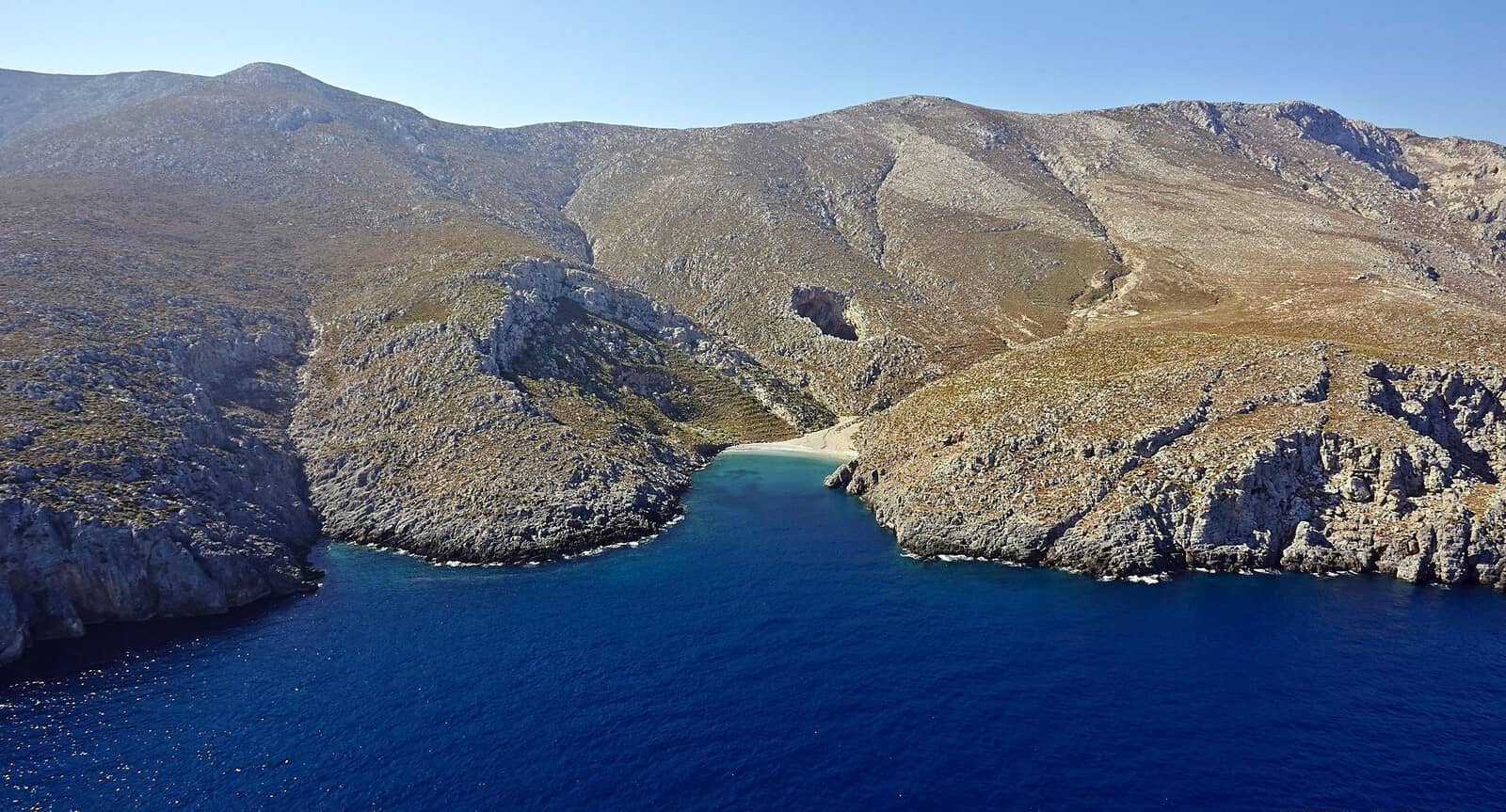
The tiny bay of Limionari - Λιμιονάρι is known by the climbing community as “Little Eden”.
It's rather shallow, so slowly approach the pebbled beach of Kampí, Kambi - Καμπι with the traditional tamarisk trees. A large caïque will bring sunseekers and will moor parallel to the beach with lines to the NE cliffs. Anchor anywhere over sand; good holding; plenty of options to take lines ashore.
Lat Long
True to its nickname this is both a brilliant anchorage, see photo above, as well as a bit too small.
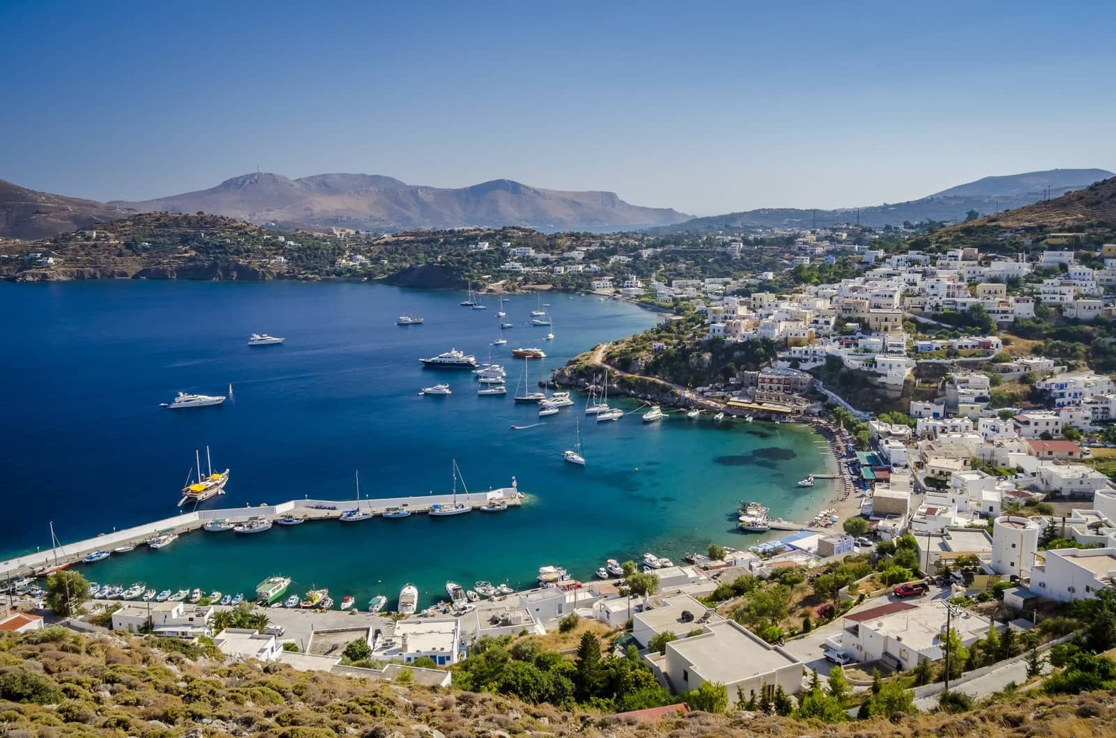
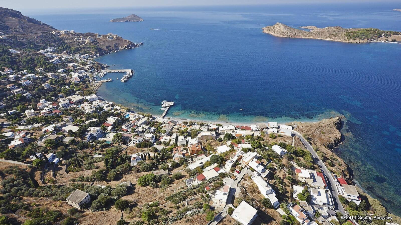
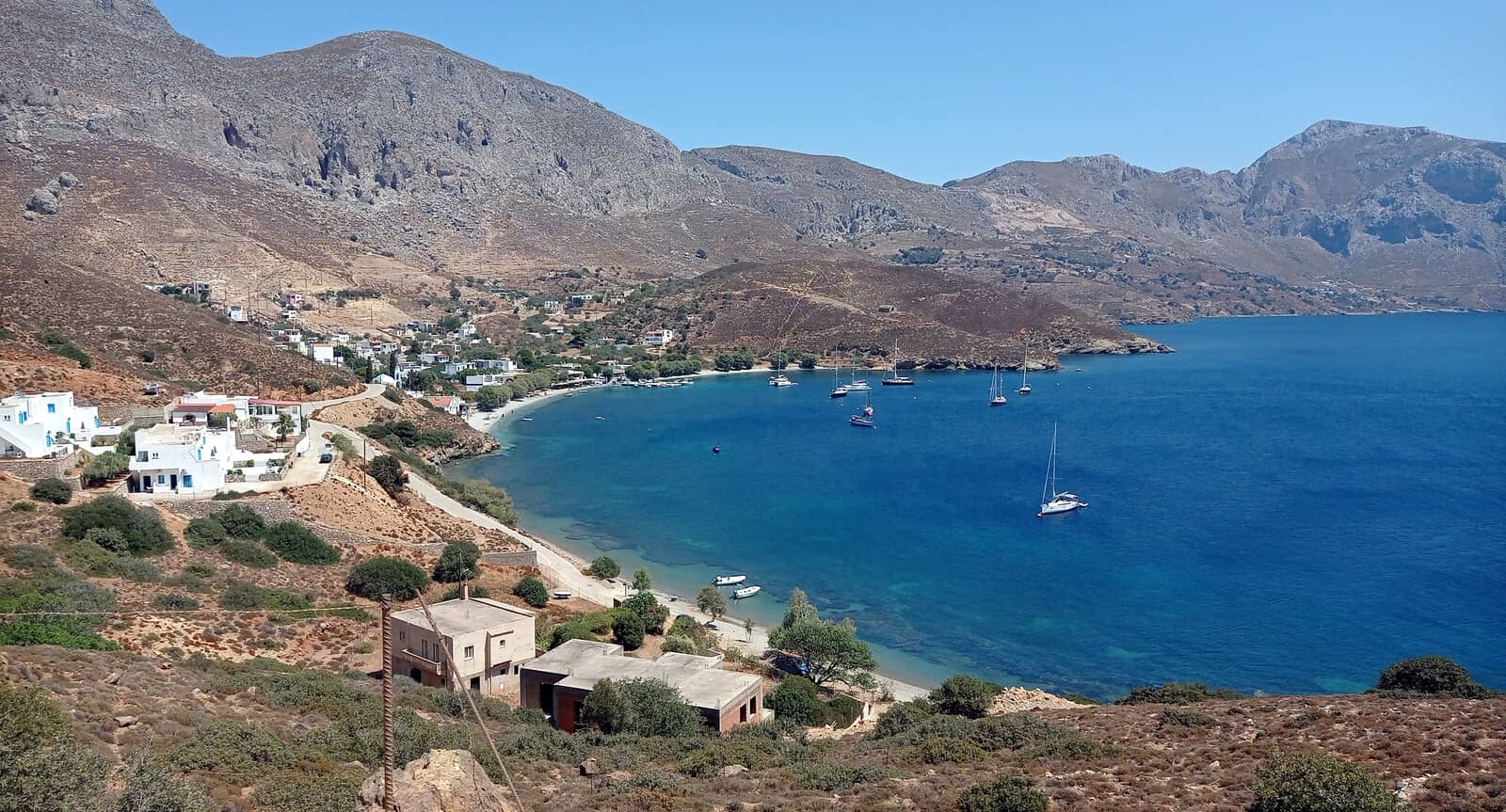
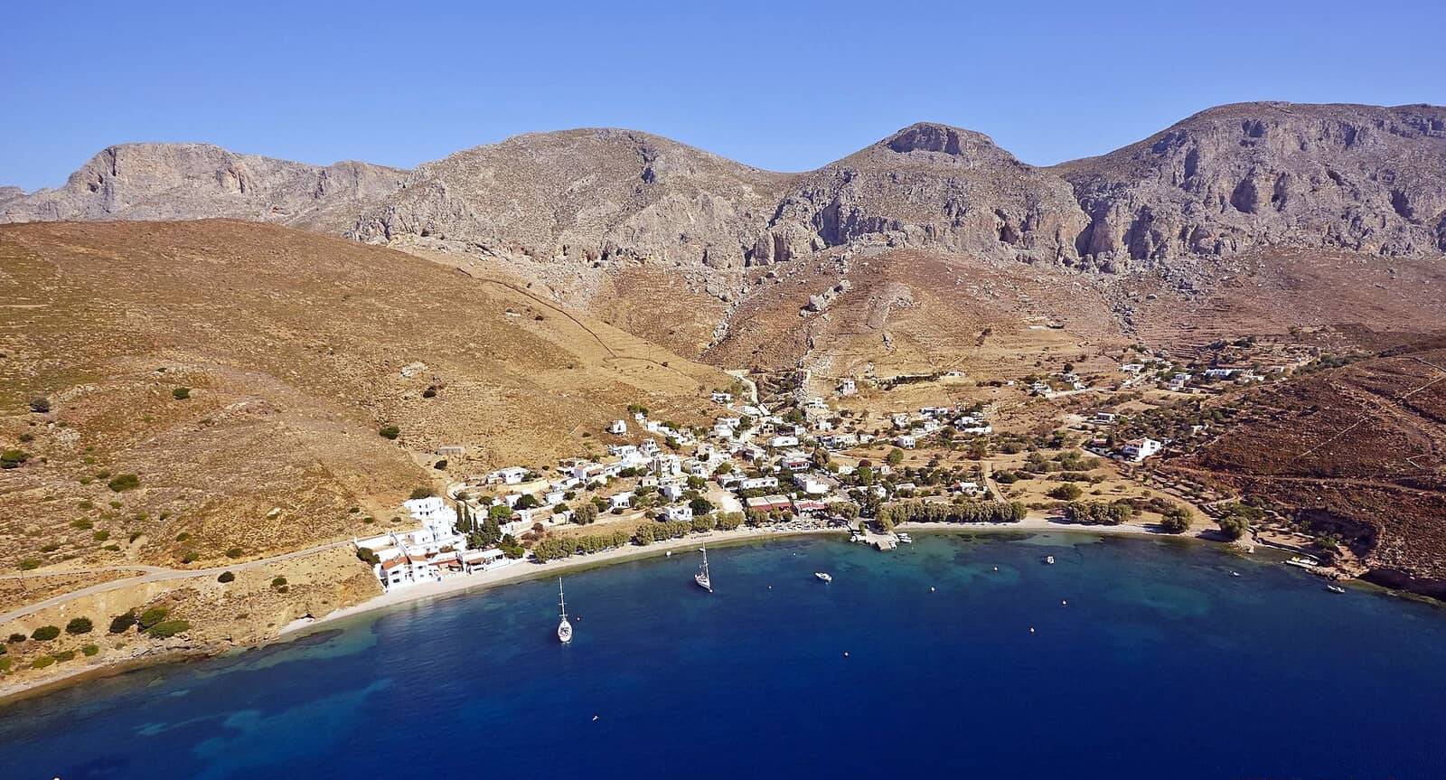
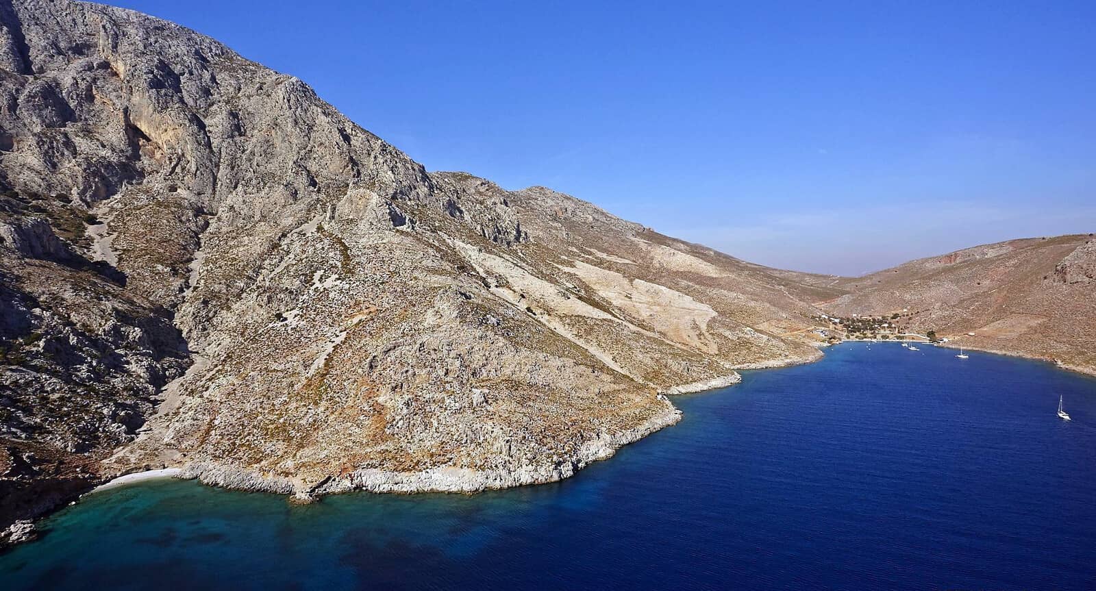
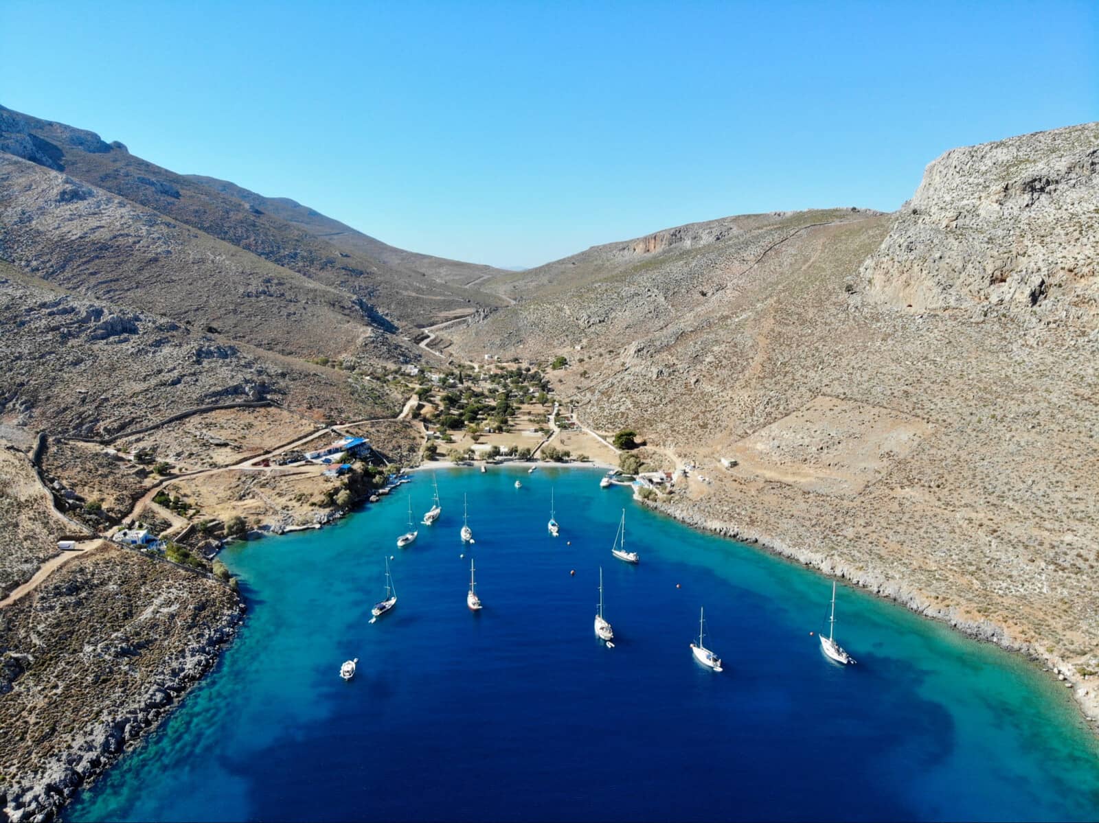
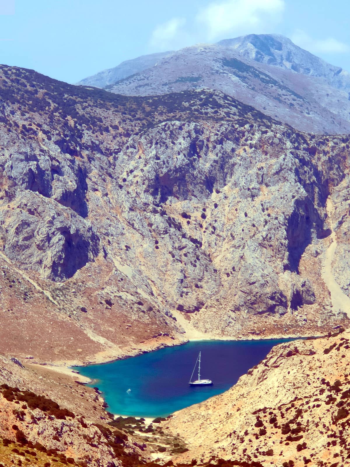
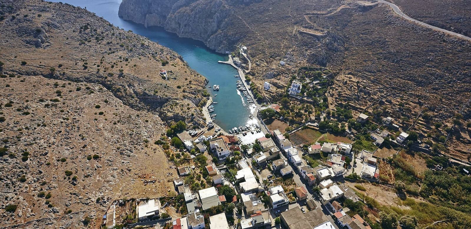
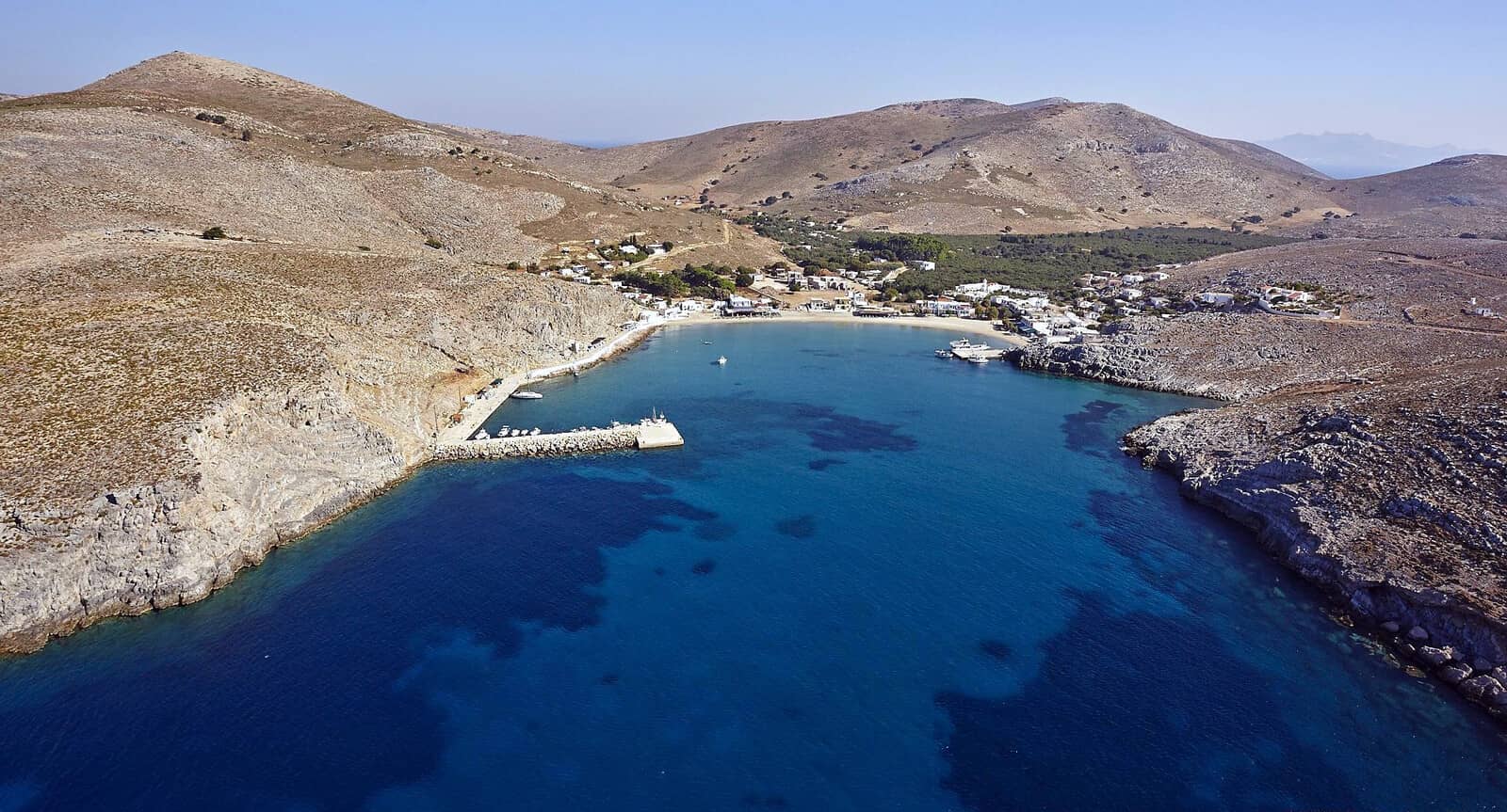
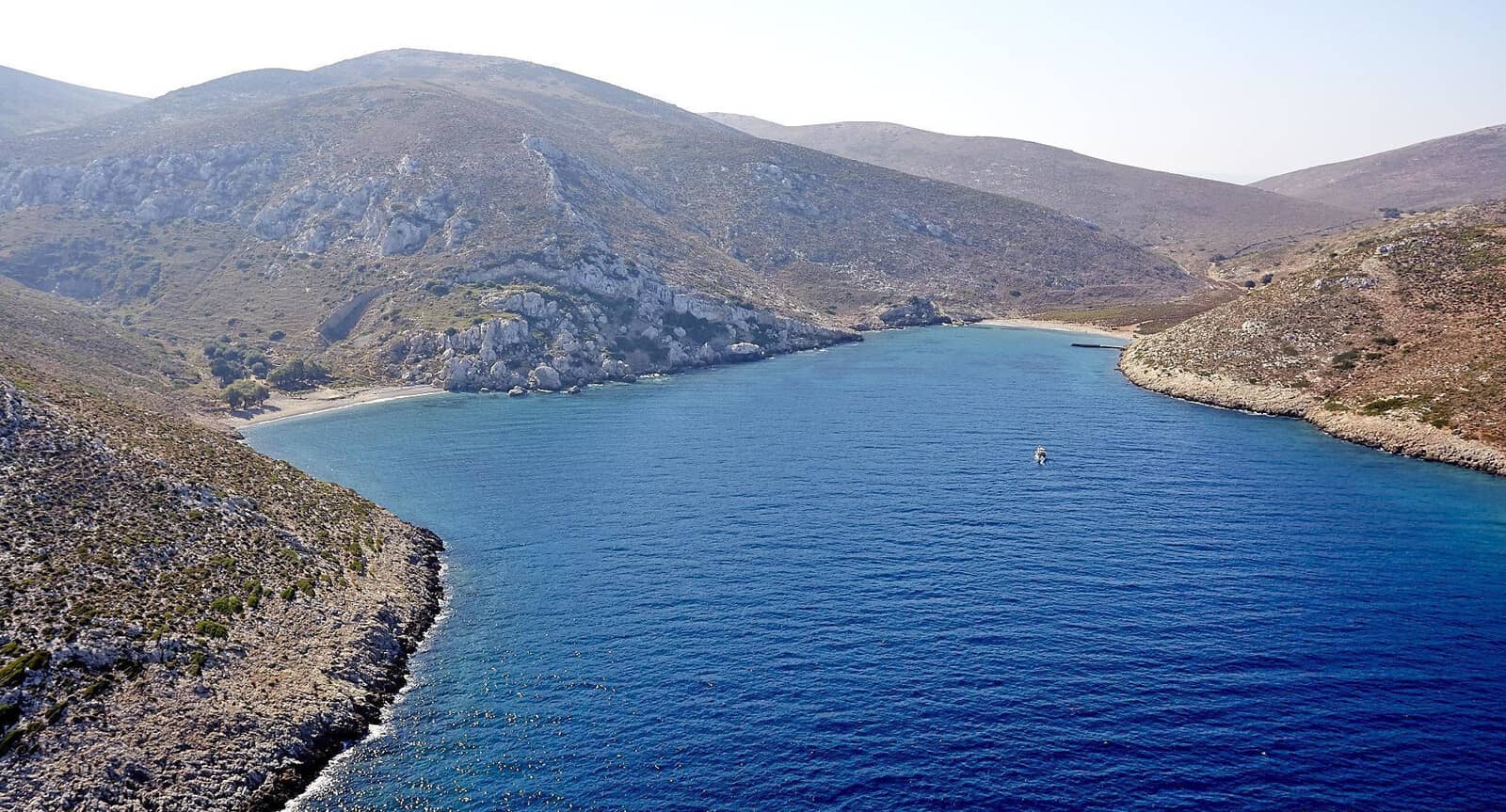
Vathys
The famous fjord-like bay of Vathys or Vathis - Βαθύς, on the East coast of Kalymnos island, is a must-see harbour. Lat Long Not to be confused with nearby Vathy on Pserimos • read about toponyms and Greek chart terms.
This turquoise inlet leads to the charming citrus-fringed fishing village of Rina - Ρίνα, which boasts one main street and a collection of houses scattered into the valley; an unexpected patch of lush vegetation on an otherwise very dry and arid-looking island.
Rina or Rhina is the only place on the entire island that is lucky enough to have it's own spring water supply, and they use it carefully to cultivate citrus fruits, figs, grapes and anything else that can be persuaded to grow!
The port seems as narrow as it is shallow, with a mere 5 m depth at the mole: the fjord's floor then rises to 4, 3, 2 m… and that is in the middle. Yet it offers allround shelter in the summer winds with mostly solid holding in sand (and some weed).

Regretfully, there is limited room for visiting yachts, 7 berths max., solely on the West side of the mole, since the East side features a shallow swimming area; the closer to the mole the better and alongside the mole is most coveted.
The unofficial – but knowledgeable – Harbour Master is Captain Manolis, who actually runs the quayside sponge stand. He is the local hero, so embrace his advice while he kindly assists you.
Ideally he is able to assign you a berth on the short mole – only possible when no caïques / gulets are present or inbound – and then either stern-to the tip or alongside on the West.
But likely you will go on the quay and you will be instructed to drop the anchor just ±4 metres off the opposite side: it's a tight fit.
Note that larger caïques might drop their anchor over all the other chains. During the day the mole is normally reserved for these tourist vessels – arriving at about 10:00 and leaving at about 16:00.
Caution is needed:
- Near the mole there are depths of <1.5 m close to the quay, further West <1 m close to the quay. Moreover, blocks and rocks are thornily protruding. Therefore keep well clear of the quay – e.g. use the dinghy as gangway – to safeguard your rudder.
- The wash created by the gulets / caïques, as well as the fast ferries outside the port, has already resulted in damage to sterns and rigging. Again, keep your yacht well of the quay; also make sure the rigging cannot come near your neighbour's rigging when rolling. Therefore, going bows-to makes a lot of sense.
The picturesque port of Vathys / Rhina is adorned with bougainvillea, and still has its original boatyard & slipway, right next to several good tavernas.
Don’t pass by the ruins of the Early Byzantine Basilica (Paleopanagia), with mosaics dated from the 6th c. CE, directly behind these tavernas.
Visit the adjacent settlements of Platanos (named after its plane tree) and Methochi in Vathys' verdant valley, where you can ramble through lush tangerine orchards and vegetable patches.
Two anchorages in case the port is full:
- Outside the port but inside this fjord-like bay is a solid anchorage for SE – W winds on the Southern side Lat Long and take a line ashore.
- On the Northern side – also outside the port – is the Church of St George set in its own green oasis, with directly East the remarkable “Manolis” DWS rock climbing cave with a swing attached to the roof. Lat Long Take a line ashore.
Manolis
The Greek name Manolis (Μανώλης, Μανόλης) is derived from Emmanouil – the Greek version of Immanuel – which is Hebrew for “God with us”. See selected words… →
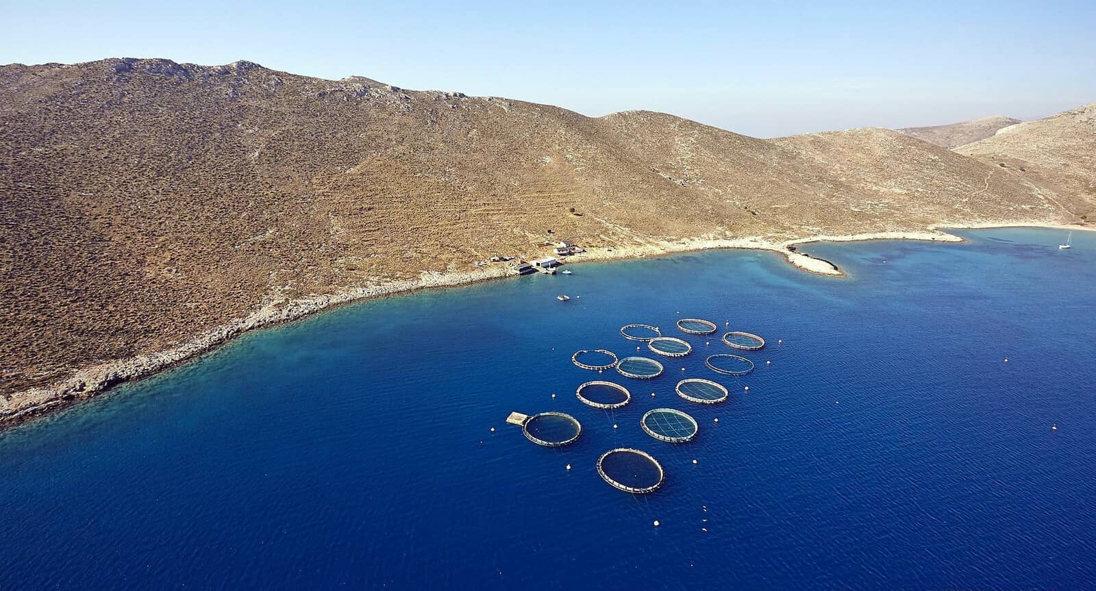
Agios Nikolaos (Akti)
Agios Nikolaos - Άγιος Νικόλαος bay
is tainted by extensive pisciculture and the least polluted spot is at the head of the bay, Lat Long off Akti - Ακτή beach.
The anchorage is open to Easterlies, with gusts from the NW. There is room for only two yacht, or more if you take lines ashore; anchor over sand in 5 – 10 m. We veered a full circle with a dragging anchor before resetting: therefore anchor in the middle, or rather treat this as a lunch-stop.
The taverna is out of business since 2020.
Unfortunately, the water here can be cloudy and opaque due to the nearby fish farms.
Note that there is a second anchorage, Ag Nikolaos South Lat Long with better holding, yet not suitable in the prevailing Northerlies.
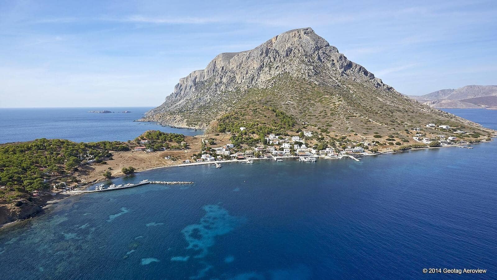
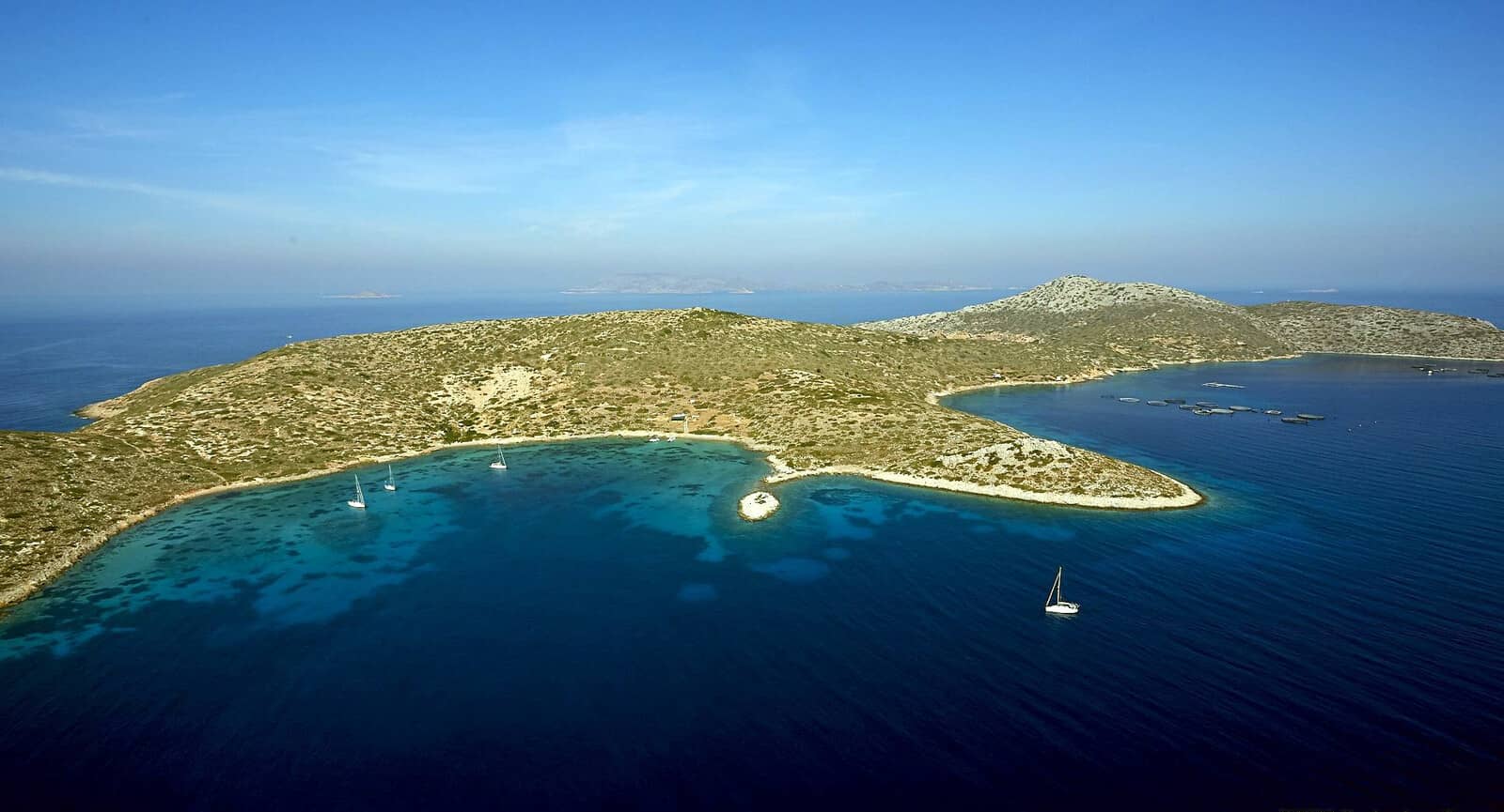
Pserimos island
The island of Pserimos - Ψέριμος is low-lying with a height of 268 m, and is home to just a few dozen permanent residents without motorised vehicles, which adds to the serenity.
Contrarily, daily ferries from Pothia, Kalimnos port do bring in beach tourists for day visits.
Rather remarkably, inland there are no real points of interest apart from the Church of the Dormition of the Mother of God, which celebrates the “falling asleep” (death) of Mary the Theotokos located in the main settlement – just outside the recently planted (6000 trees!) olive orchard – where its detached belfry can easily be spotted. Locally this Church is called “Melachrin” (Brunette), referring to a dark stained icon of Mary that was, as always, “miraculously found” by a fisherman.
The SE Cape of Roussa is disdainfully decorated with a large Greek flag easily visible from Turkey.
Along the South coast of the island there are several good lunch-stop anchorages; some swell from ferries.
On the West coast is the lovely Grafiotissa beach, with – on the low cliffs – a new Church. The previous Sanctuary was partly washed away by waves in 2016: best appreciated from the water.
Pserimos port
The modest port of Pserimos - Ψέριμος is located in a shallow bay at the tiny village, Chora or Avlakia - Αυλάκια, which consists chiefly of a beautiful beach with a few tourist shops and tavernas.
The quayside (on the inside of the ferry mole) is reserved for caïques and “pirate” ships (upto eight) from Kos and Kalymnos, but from ~16:00 there is room to dock for visiting yachts; go stern-to the quay. During the day the party boats bring in noisy guests; most will only stay 1 or 2 hours.
Katabatic gusts are typically from the NW. In <6 Bft a swell will penetrate the harbour: rolling conditions. The whole basin is shallow, anchor anywhere over sand, avoid the patches of weed.
There is shelter from NW – SE winds, and if behind the mole from Westerlies.; the NE corner has some rocky ledges; the submarine cables are seemingly ignored by anchoring yachts: anchor in 3 – 4 m, ideally not near these cables.
Avlakia proffers three good restaurants: “Aphrodite”, “Anna” and “Manola”, the latter is our favourite: Maria and Georghios will pander to you.
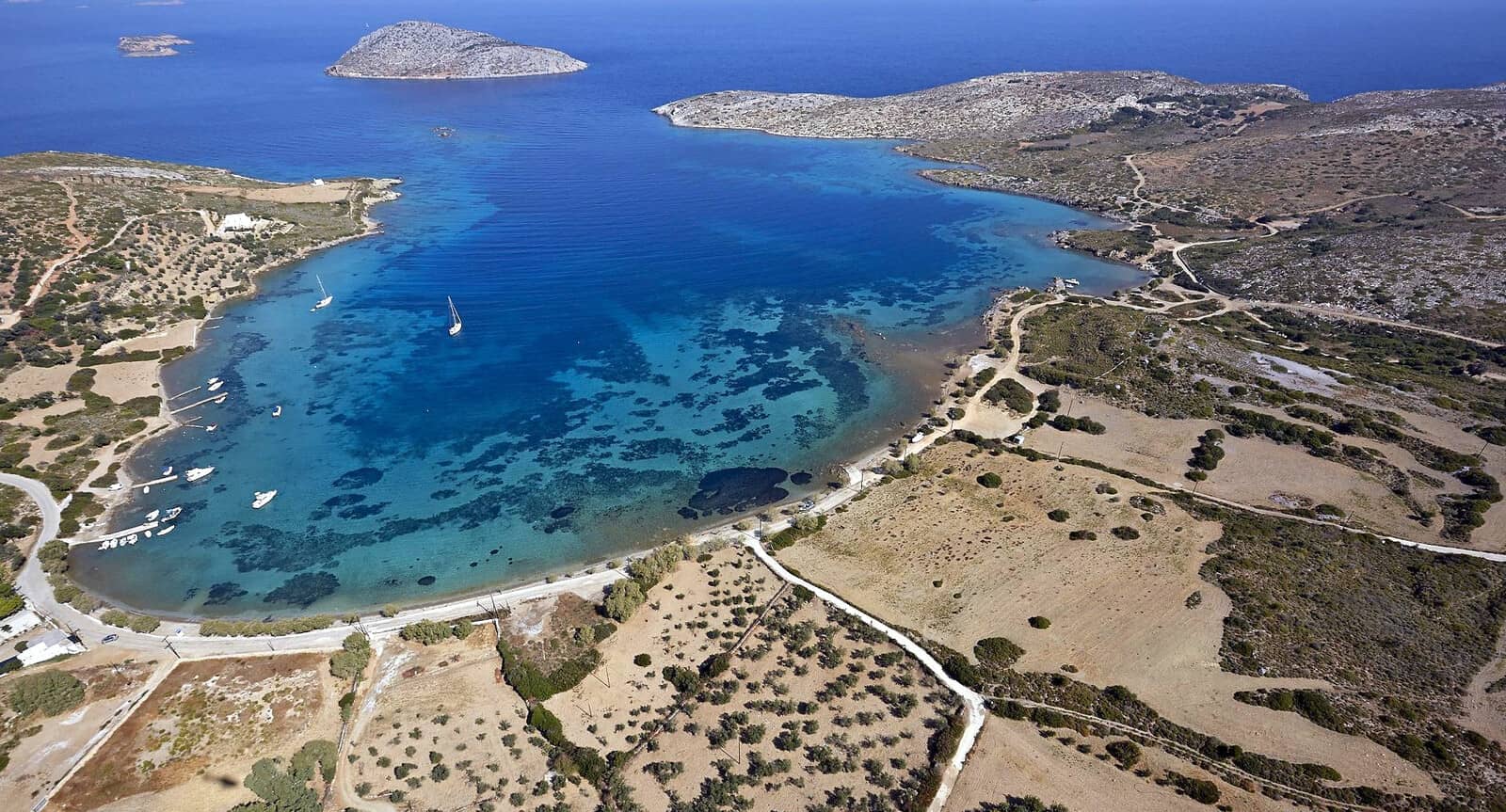
Vathy
Vathy - Βαθύ bay offers a lovely anchorage close to the quite agreeable beach, Lat Long with good shelter against the Meltemi (with hardly any swell) and SSE – NE winds; solid holding, anchor over sand in 3 – 7 m. The remaining fish farm directly South is well lit at night. The other fish farms in the wider bay area are gone (for the moment). Tourist boats shuttle sunseekers during the day; in the weekend also crowded with charter yachts coming from or returning to Kos, there is however lots of room.
South in Vathy bay, Lat Long is an interesting alternative since the fish farms
![]() in this area have gone (still shown on some maps, notably Navionics and Imray). Note that the negligibly-visible wreck
in this area have gone (still shown on some maps, notably Navionics and Imray). Note that the negligibly-visible wreck ![]() is still there, developing into a
is still there, developing into a ![]() .
.
North in Vathy bay, Lat Long from this tiny cove till Vathy's beach anywhere in 6 – 10 m over fine pebbles and sand; exposed to NE – SW winds;
Maratho (Marathonta)
The bay of Maratho (Marathonta) - Μάραθο (Μαραθώντα), is off the beaten track, but really only suitable in the unusual ENE – WNW wind conditions.
At Tafos beach on the East side there are remains of a former tile factory, and deep pits to fall in . It is this cove that offers the best protection; Lat Long not everywhere good holding in sand / weeds; options to take a line ashore.
Maratho is rarely used by yachtspersons as the prevailing winds are Northerlies.
Moreover, the main beach – being a lee shore – receives lots of rubbish.
Platy + Nekrothiki
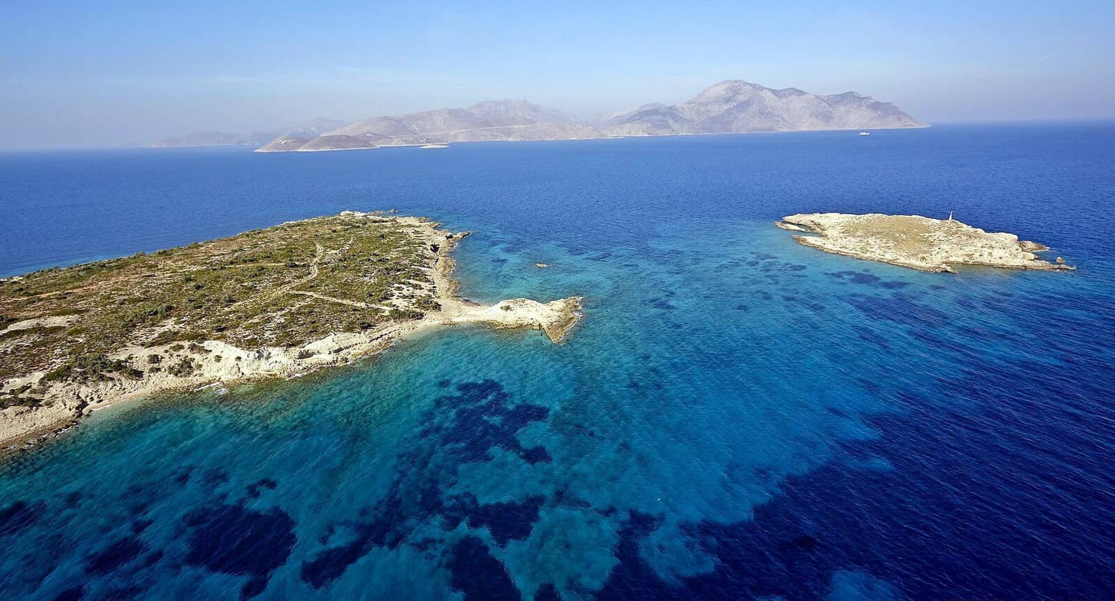
The small islet of Platy (Nekro) - Πλατύ (Νεκρό), to the West of Pserimos island, offers three anchorages:
- Northwestside Lat Long
Exposed to W – NNE winds, anchor over sand in 3.5 – 6 m; solid holding in crystal clear waters, yet the shoreline could do with some plogging. - Eastside, at the Church of St Nikolaos Lat Long
Really the whole stretch of coast (aka “Akti beach”) North of the Church can be used. Open to NNW – SW winds; lunch stop; anchor over sand anywhere. - Northside, between Platy and Nekrothiki - Νεκροθηκή islets Lat Long
This is a traditional Meltemi-proof haven. Open to Easterlies and Westerlies.
Caïques and “pirate ships” dock at the Church bringing noisy party guests who litter the beach – fortunately only in the summer months – from Pserimos port.
Suitably “Platy” means ”flat, like a plate” in Greek: compare platypus.

Leros island

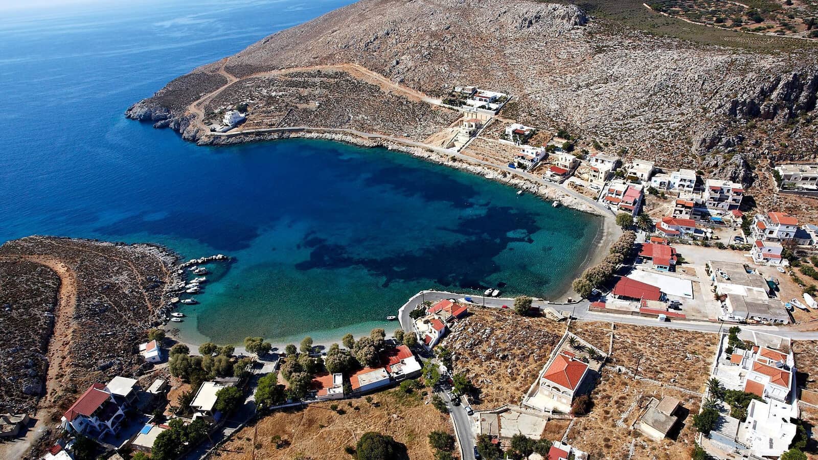
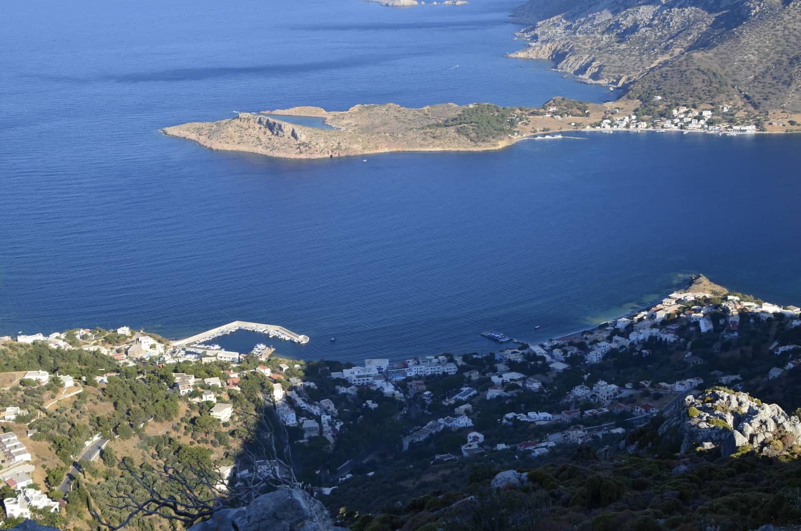
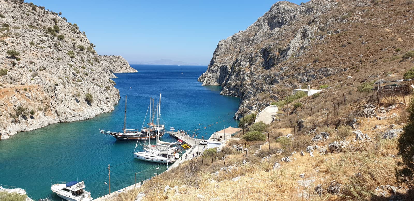
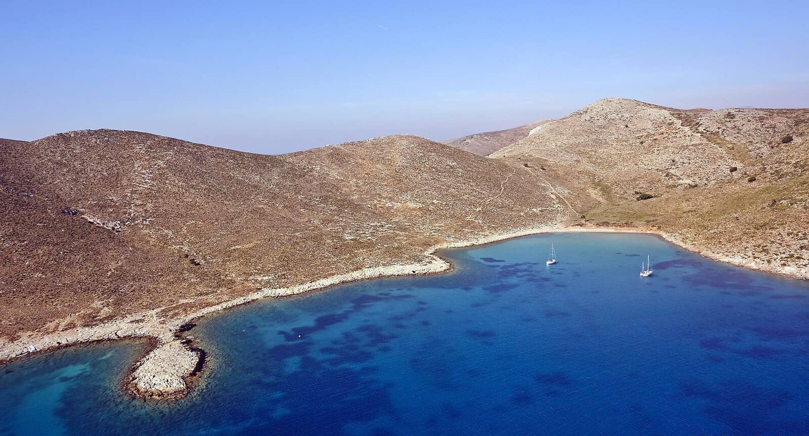
Xirokampos
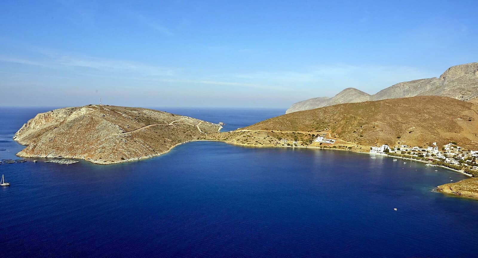
The bay of Xirokampos - Ξηρόκαμπος is a (surprisingly) popular anchorage, with lovely seascapes towards Kalymnos and the Glaronisi + Velona / Leriko isles in the Leros – Kalymnos strait.
No doubt too crowded in season for some yachtspersons, yet a convenient location while traveling N↔S, and with shelter from SW – E winds.
Solid holding; sand (+ weed, be careful where you drop anchor); excellent in the prevailing summer northerlies and even Meltemi.
Restaurants ashore: “Trehantiri” , “Aloni” , and “To Kyma - Το Κύμα”.
Water tap South of the football field.
Eagleray and the 2022 GWP still mention the mooring buoys:
- 2019 June: 30+ buoys; yellow for Aloni, white or orange for the other restaurants.
- 2019 Oct: the buoys have been forcibly removed by Port Police.
- 2020 Sept: ten buoys in place.
- 2021 May: only few plastic bottles that will indicate the mooring buoys because otherwise the tavernas are taxed by the Port Police, but can be used.
- 2021 June: there are no more buoys; use a trip line when anchoring, seabed still fouled.
- 2021 Aug – 2022 June: no mooring buoys, but blocks on the seabed remain, and you can attach lines.
- 2022 Aug: yet again a few plastic bottles marking the blocks.
Visit the remnants of the Castle of Lepidos (Paliokastro) with cyclopean walls 2500 BCE, located half a kilometer North of the football field – look for the white-washed Church of Panagia (Maria, Madonna).
Lakki
The large bay of Lakki - Λακκί can be challenging in Meltemi as well as in strong Southerlies, but fortunately – aside from 3 anchorages – it features two marinas.
The entrance of Ormos Lakki (Lakki bay) is only clearly visible looking NE. Once inside the bay Lakki town will be seen. This bay is one of the largest natural harbour in Greece, almost resembling a lake with its tiny opening of just 400 m.
The town's ambience changed after the Italian rule in 1923 and as a result of that, new large buildings were built, and wide and well paved roads were constructed. Near the waterfront there is a monument to those who perished in 1943 when a Greek ship, the “Queen Olga” was attacked by German planes and sank in Lakki's harbour.
Leros Marina, in the East of the head of Lakki bay, offers about 145 visiting berths; a pilot boat will assist with mooring and picking up the permanent mooring lines.
Reservation: Leros Marina; VHF 10; Tel +30 22470 24733, +30 22470 26600, +30 22470 26601;
info@lerosmarina.gr.
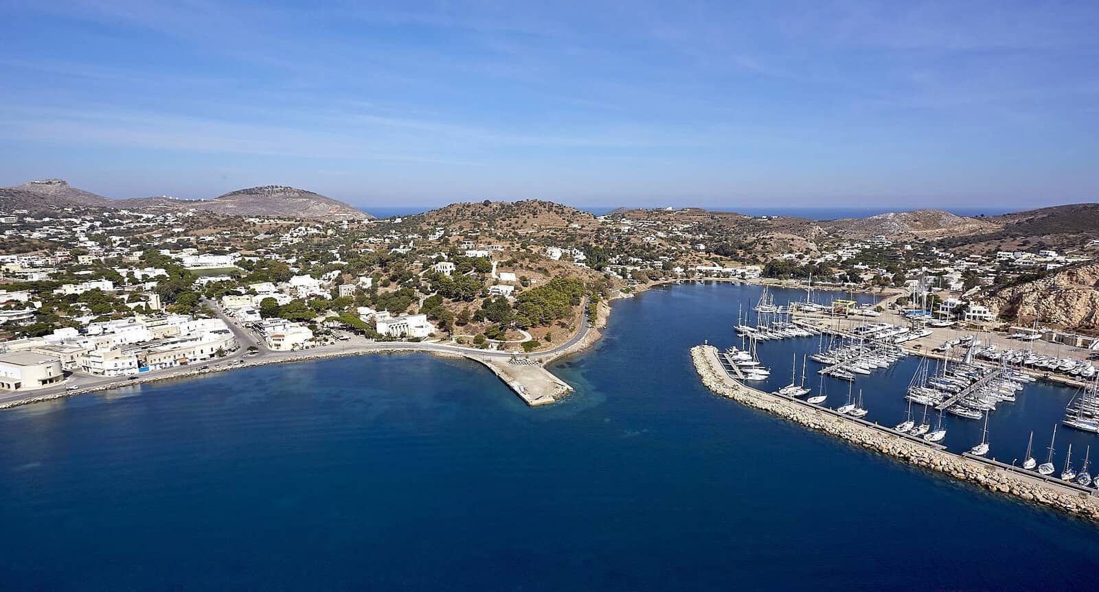
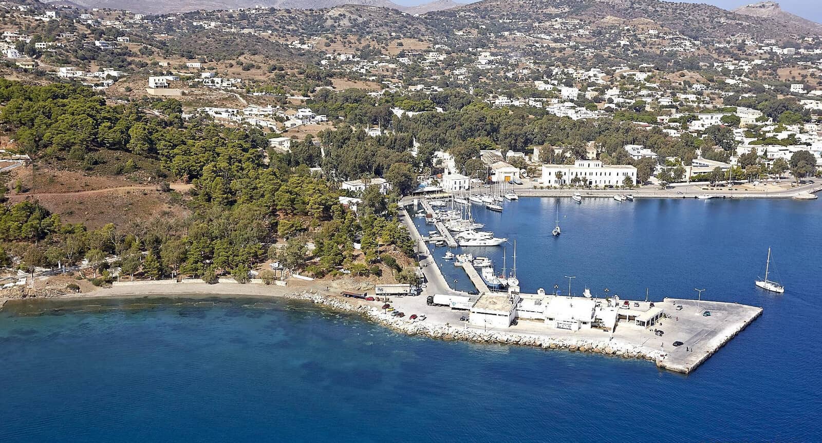
Lakki marina, in the West of the head of Lakki bay, offers 45 berths and allround protection (very Meltemi proof); ferries dock on the wide South quay.
Smaller and roughly half the price of the Leros marina.
Reservation: Lakki Marina; VHF 11; Tel +30 690 940 0488;
lakkimarina@moor-dock.com.
Assistance with attaching the permanent laid moorings.

“ΤΑ ΚΟΡΑΚΙΑ” (the raven / crow) for vegetables & fruit.
Visit the “Leros War Museum” at Merikia, a 15 min walk West along the coast, see Merikia anchorage below.
Anchorages in Lakki bay are affected by ferry wash:
- Koulouki - Κουλούκι, directly West of the ferry quay – both bad and solid holding in places, room for about 5 yachts to swing; anchor in 5 – 6 m over sand / mud; verdant surroundings.
- Merikia - Μερικιά bay is less protected, less verdant and less attractive.
One bar plus one taverna ashore. Careful → in the middle of the bay, on a 3 m depth line there is a wide shoal with rocks. There are also buoys on the East side that belong to the noisy "Lime" beach bar; good snorkeling; Restaurant “I Kouzina Tis Popis” (The kitchen of Mrs Popi !) is a must. Also visit the War Museum. - Kokkina - Κόκκινα is a nudist beach attracting scopophiliacs (peeping Toms), directly SW–adjacent there is a stretch of insupportable fish farms ), this bay is not recommended.
Leros town has intriguing historical and fascist architecture.
Gournes + Drymona
The sizeable bay of Gournes - Γούρνες or Gourna - Γούρνα, located above Lakki, is only occasionally used by yachtspersons.
Conspicuous are the seven wind turbines that are tightly placed together North of the Church of Agios Isidoros.
Note the Kantilia reefs and the Nes Gourna – “Nes” is short for “small islets” – in the middle of Gournes bay: these are hazards W – NW winds can cause waves to cover Nes Gourna.
The bay has three anchorages and a fishing harbour:
- Southside Lat Long
In ENE – SW winds anchor in the small Lavatses cove: lovely remote, nothing ashore. - Eastside Lat Long
A gently slooping sandy anchorage, open to SW – NW winds. Moreover, SW winds cause rolling conditions. Anchor in 3 – 5 m. Reasonable Fish tavern “Ψαροταβέρνα Γούρνα”. - Northside Lat Long
There is a dam (walk way, lit with four street lights) connecting the islet and Church of Ag. Isidoros to Leros. You can anchor directly East in 4 m but there is lots of seaweed, and despite the high mountains there is not much shelter (hence the wind turbines).
Finally, there is Drymona(s) - Δρυμώνας harbour in the South, which is reserved for fishing boats and has depths <2 m. However – now confirmed, Sept 2022 – 3 yellow mooring buoys near the entrance can be used.
The adjacent “Sotos Ouzeri” is the best restaurant in the area.
Many rocks and reefs protrude from this stretch of coast.
Partheni bay + Kalo Pigádi
The bay of Partheni - Παρθένι
is guarded by the Archangelos islet and has offers allround protection in the East corner, which is known as Kalo Pigádi - Καλο Πηγάδι.
There are military installations (including restricted areas and occasional cannon shots), two boatyards
(Artemis [recommended]
and
Moor & Dock [Lakki marina]), fish farms, commercial shipping and of course the airstrip of Leros airport: summa summarum this is quite a depressing venue.
The best (safest, not prettiest) anchorage is Lat Long at Kalo Pigádi; solid holding in mud and sand; murky waters due to the fish farms; mooring buoys are private.
The small “West bay” is just out of sight on the left. Lipsi and Patmos islands on the horizon.
Archangelos islet
To the North of Leros lies the low islet of Archangelos - Αρχάγγελος that offers medium to good shelter in Meltemia.
In Orthodox Christianity the compound word “arch+angel” mainly refers to either Micheal or Gabriel as “chief angel”.
The wider easternmost bay under the island has been fouled – since circa 2010 – by fishfarms.
However, the other two bays are a delight with beautiful waters; from West to East:
- West small bay Lat Long
Reasonable protection from Meltemi and open to ENE – SE.
Anchor over sand (and weed in deeper areas), preferably close to the shoreline where there are plenty of options to take lines ashore. Small desembarkation pier for the dinghy. This anchorage is more serene than the Taverna bay around the corner. - Middle “Taverna” bay Lat Long
Anchor anywhere over sand, some of it hard sand plus rocky slabs, therefore medium holding, aim for a depth of 3.5 – 5 m.
Fortunately, there are 5 mooring buoys – attached to simple concrete cylinders, somewhat smallish looking, but proven adequate – maintained by the wonderful people of the Taverna who replace the lines of the mooring buoys each season; reservations via Tel: +306933409648.
Conspicuous from afar is the solar paneled rooftop of the “Taverna Stigma” - Αγουρος Αναστασιος Agouros Anastasios; fish served here is freshly caught, not from the fish farms!
Open to ESE – SW. - Eastern polluted wider bay Lat Long
Filled with fish farms, but decent shelter and good holding.
Faradonisia (Farios) islet – located West of Archangelos islet – is also polluted by pisciculture.
Blefoutis / Plakouti
On the Northside of Leros island is Blefouti(s) - Μπλεφουτἡς beach in Plakouti - Πλακούτη bay, sheltered by the islets of Trypiti and Strongylo, offering nearly allround protection, even from Meltemi, especially in the East. Lat Long anchor in 3 – 4 m over sand. In lighter winds or Southerlies you can anchor anyplace.
There is a reef extending from the West side of the entrance, so keep to the East.
In Southerlies the bay can hold dozens of yachts, anchored also in depths over 8 m.
Near the pebbled beach in the SE is a good taverna.
Blefoutis is named after its blue “μπλε” water.
Note the shallow reefs and rocks in the Western part of the entrance.
Taverna bottom left between the piers and the beach.
The island's capital Platanos crosses this headland and incorporates the tourist resort of Agia Marina and Panteli.
Alinda • Agia Marina
Alinda bay is situated at the East side of Leros and is easily located by the Venetian castle higher up. There are two villages: Alinda(s) on the NW and Agia Marina on the South.
Alinda - Άλινδα
The bay is exposed to NNE – SE winds; NE wind in autumn; in summer expect N in the morning, followed by light winds, followed by NW in the afternoon. Early in season expect moderate W + NW winds.
In Northerlies there are 2 anchorages Lat Long and Lat Long at Alinda village; relatively solid holding in sand + weeds.
To Steki restaurant (+30 2247 022413) offers 4 mooring buoys – not verified.
“Argo café bar” is a delight.
Visit the museum in the “Belenis Tower”, built in 1927 by Parisis Belenis, a rich Greek from Egypt who became a benefactor of Leros.
Ag Marina - Αγία Μαρίνα
In light conditions and preferably not in Northerlies you can moor (alongside) on the SW section of the square ferry quay. If these berths are unavailable, anchor directly West over sand and some rocks / weeds. The village of Ayia Marina – Saint Marina is very pleasant with flowers, picturesque houses and tranquil alleys.
Just South of the Archaeological Museum is the authentic “Σουβλάκι το Πικολο” (Souvlaki to Pikolo), obviously not for vegetarians.

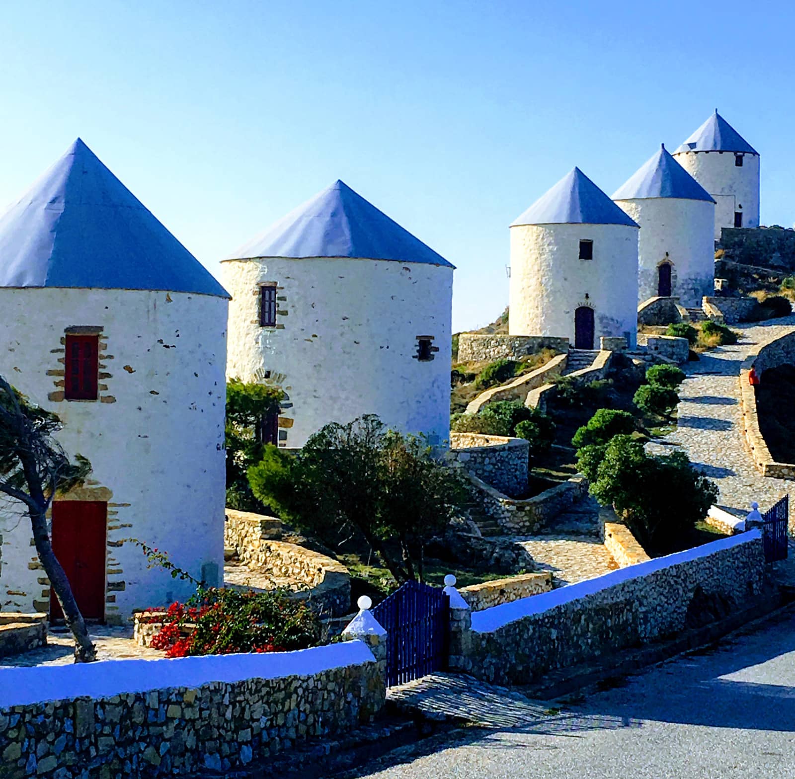
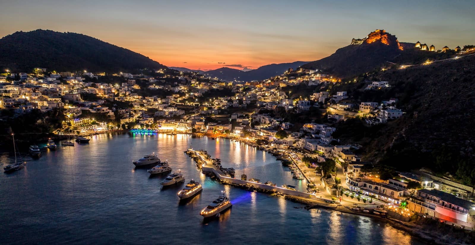
Panteli
The small port of Panteli - Παντέλι is part of Platanos, the island's capital with its conspicuous medieval castle and the 6 windmills above it. Further in you will see the lower situated white windmills that are converted into apartments.
Visiting yachts are still more or less “tolerated” on the inside of the port, where you should go alongside (raft up), ask the local fishermen first: all-round protection. The bay itself is exposed to E – SSE winds.
Mooring buoys → from 2 (2018) to roughly 12 buoys (2022); Lefteris Koutsanellos (Harbour Master) on his green boat will assist you mooring to a buoy (€2 per meter); Mob.: +30 6977778440 / Tel.: +30 2247028655; VHF 73; Punta Del Mar • Cafe Del Mar reservation form, and email: admin@puntadelmar.gr or lkoutsanellos@gmail.com .
Plenty of yachts opt to take (a long) line to the breakwater or to the shore near the Cafe Del Mar and this also can be arranged by the Harbour Master.
The fourth option is to anchor without a mooring buoy or line to the shore; anchor over sand with patches of weed (easily avoided); medium to solid holding.
The Southern part of the bay is known as Vromolithos (“βρομο” dirty or smelly, or as a verb: to crash, and “λίθος” stone, perhaps pointing at the rocks near the beach on which you can crash the dinghy's outboard).

Motor yachts have taken lines to the shore.
Note the six conspicuous windmills on the ridge as well as the imposing medieval castle. Hi-res image
Panteli town has a voguish vibe, plenty of adequate & expensive restaurants, none exceptional though. For non-food you should certainly try Harris bar (cocktails ) overlooking the port from higher up, and for the suger-rush there is “Sweet Leros” – an English tea room mixed with a Greek bakery – overlooking the port from sealevel.
Visit Leros Castle (Panteliou) - Κάστρο Λέρου (Παντελίου), an early bastionated fortress as an extension of a Byzantine castle on the site of an ancient acropolis.
The Archaeological Museum, which is actually closer to Ayia Marina, holds a modest collection.