See the previous chapter…
- Course overview: goals and introduction
- Positions: latitude, longitude, nautical mile, scale, knots
- Nautical chart: coordinates, positions, courses, chart symbols, projections
- Compass: variation, deviation, true • magnetic • compass courses
- Plotting and piloting: LOPs, (running) fix, dead reckoning, leeway, CTS, CTW, COG
- Advanced piloting: double angle on the bow • four point • special angle fix, distance of horizon, dipping range, vertical sextant angle, radians, estimation of distances
- Astronomical origin of tides: diurnal, semi-diurnal, syzygy, spring, neap, axial tilt Earth, apsidal • nodal precession, declination Moon and Sun, elliptical orbits, lunar nodes
- Tides: tidal height prediction, chart datums, tidal curves, secondary ports
- Tidal streams and currents: diamonds, Course to Steer, Estimated Position
- Aids to navigation: buoys, leading lights, ranges, characteristics, visibility
- Lights and shapes: vessels sailing, anchoring, towing, fishing, NUC, RAM, dredging
Positions
Latitude and longitude
The earth can be regarded as a spherical object, and since we're dealing with a 3-dimensional shape we need coordinates of a different form than the usual x- and y-axes. Though adding an extra z-axes would make sense for submarines, we will most likely be found on the surface of this sphere while using another system of coordinates, meridians and parallels, see figures below.
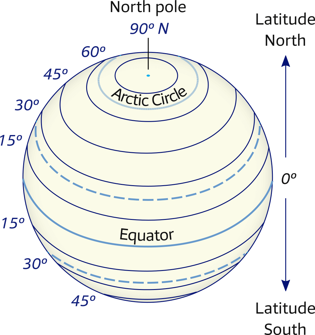
Dotted lines are Tropic of Cancer (north) and Tropic of Capricorn (south).
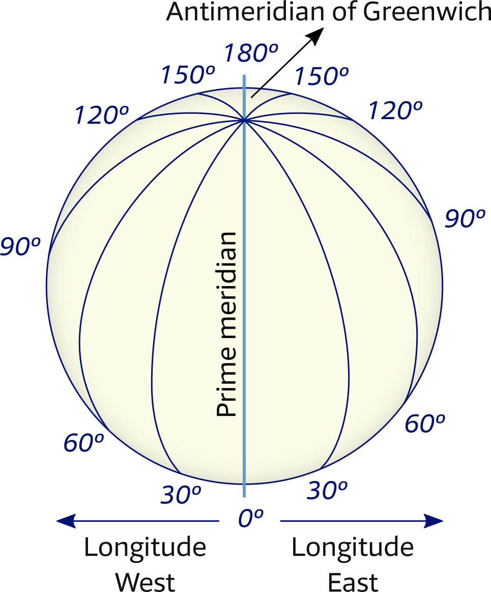
Figure 1.2 – Meridians of Longitude
The Prime Meridian together with the
Antimeridian form a great circle.
All these lines together provide the grid which enables us to describe any position in latitudes N S together with longitudes W E .
The obvious place to divide the northern and southern Hemispheres was the equator.
But the division of the eastern and western hemispheres was the source of much political turmoil. Greenwich (England) won, placing for example The Netherlands in the eastern and Ireland in the western Hemisphere.
It takes the earth 24 hours for a full rotation of 360°. Thus, every hour we rotate 15° longitude. The two world maps of Figures 1.3 and 1.4 show the grid and therefore the meridians in 30° intervals: 2 hours.
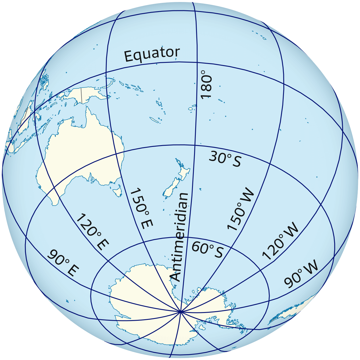
centered on New Zealand and the Antimeridian.
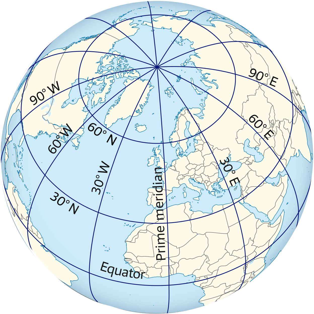
Figure 1.4 – Northern hemisphere
centered on Greenwich and the Prime Meridian.
When it is 12:00 UTC (international standard time) – anywhere in the world – it is 12:00 Local Time in Greenwich and 24:00 Local Time at the other side of the planet: 180° E or 180° W: roughly the International Date Line. Crossing this special meridian changes not only the hour but also the date.
The North Pole has a latitude of 90° N and the South Pole 90° S. The meridians cover twice this angle up to 180° W or E.
Meridians converge at the poles, whereas parallels run parallel to each other and never meet. All meridians and the equator – which is the biggest parallel – form great circles, and the remaining parallels form so-called small circles. A great circle divides the earth in two exact halves, see the glossary below.
For clarity, in Figure 1.5, the position of New Orleans is shown using latitude and longitude only in degrees.
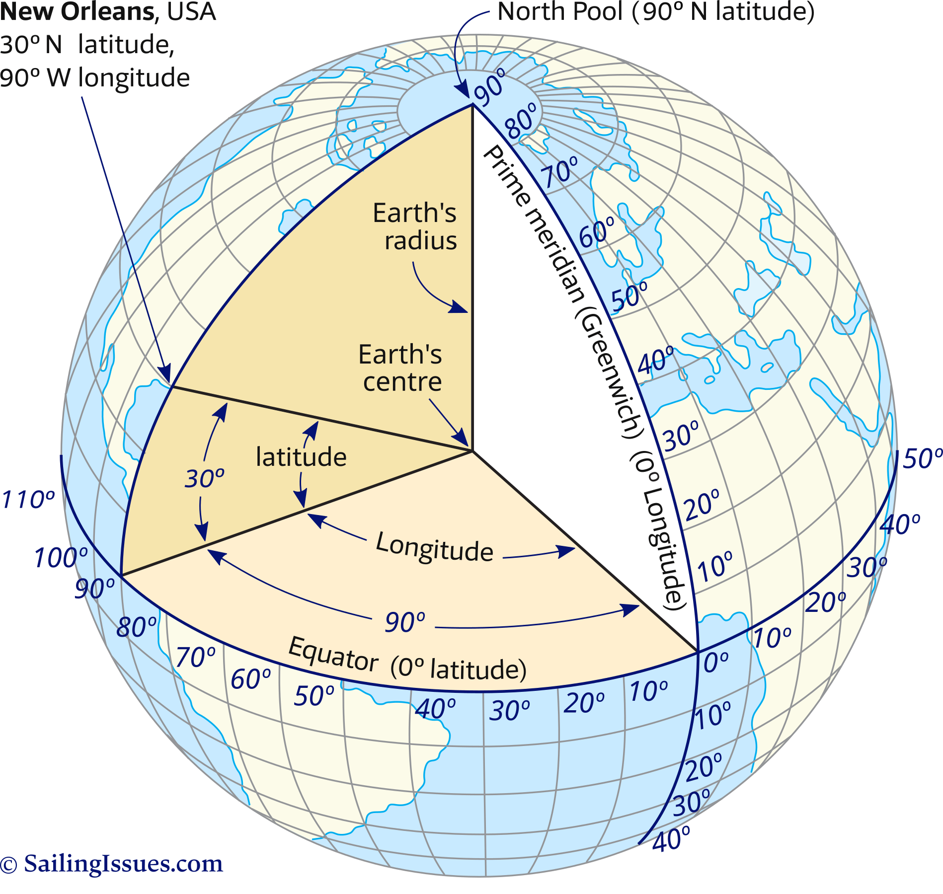
Latitude New Orleans is 30° north of the equator.
Longitude New Orleans is 90° west of the prime meridian.
Often more precision is needed with coordinates notated in degrees °, minutes ', one-sixtieth of a degree. And, optionally, seconds " – which name is derived from the Latin “pars minuta secunda”, literally meaning 2nd smallest part – one-sixtieth of a minute.
With more precision in mind, the detailed coordinates of New Orleans are:
29° 57' 20" N 90° 04' 30" W
Customarily, yachtspersons use metric fractions of minutes instead of seconds:
29° 57,333' N 90° 04,500' W or
29° 57.333' N 90° 04.500' W
see the notation style guide.
Nautical mile
If the earth were a perfect sphere (with a circumference of roughly 40000 kilometres) all great circles – meridians plus the equator – would have the same length and could be used as a distance unit when divided into 360 degrees, or 360° × 60' = 21600' minutes.
In 1929, the international community agreed on the definition of 1 international nautical mile as 1852 metres, which is roughly the average length of one minute of latitude i.e. one minute of arc along a line of longitude (a meridian).
Or to put it shortly: 1 NM = 1'
Scale
On small scale charts (covering a large area, e.g. 1:500 000 for passage / landfall) we want to be accurate within one minute or one nautical mile. On large scale charts (covering small area, e.g. 1:50 000) the accuracy is more likely to be well within a tenth of a mile: a cable.
Coastal navigation: 1:350 000 – 1:75 000
Approach of ports, or intricate / congested coastal waters: 1:75 000 – 1:30 000
Harbour/anchorage / narrow straits: larger than 1:30 000
meaning that 1 cm on the chart represents 30 thousand cm = 300 m in reality.
Knots
We are now able to describe any position in latitudes and longitudes.
Moreover, we can state the distance between two of those positions using nautical miles or minutes.
All that remains now is a proper way to define speed, and yachtspersons use knots: nautical miles per hour, e.g. the yacht has a cruising speed of 10kn, or winds over 25kn are forecast.
The ISO standard symbol for the knot is kn, although in aviation also kt is used.
In a more colloquial sense the symbol knot/knots – written in full (plural) – is the recognised standard.
The origin of the term “knots” dates back to pre-industrial times when a line, with actual knots in it serving as markers, was used as a log (a ship's instrument to measure speed). This original ship log was dropped over the stern of the moving vessel and the line allowed to pay out; the number of knots passing through the hand of the sailor were counted while a marine sandglass was used as a timing device.
RYA & ASA sailing schools
To put this navigation course into practice a Royal Yachting Association or American Sailing Association approved sailing course is recommended: sailing schools Greece.
And the most enjoyable way to learn how to sail is by combining such courses with a yachting vacation in especially the Saronic Gulf near Athens or the Ionian Islands in the west of Greece, which provide reliable and gentle winds, dolphins and ancient Greek temples.
A little History
Mariners during the 13 – 15th century relied increasingly on charts called portolans to assist them on their voyages. Portolan comes from the Italian word portolani which were medieval pilot books.

This chart is based on the work of Diogo Homem, who made a series of portolans in the 1550s and 1560s, and is the first transition of the portolan from manuscript to copperplate printing, thus illustrating a fascinating moment in hydrographic history, furthermore with Waghenaer’s pioneering printed sea atlas only two decades later.
Note that portolans combined elite and craft knowledge from Arab, Byzantine, Western Asian, and not solely medieval Mediterranean.
The portolans contained maps of coastlines, locations of harbours, river mouths and man-made features visible from the sea. Any listed (geographic) feature could now be located through the use of its distance from a ship's point of departure.
They were a compilation of centuries of seafarer observations, thus as sailors' skills improved and the use of the compass (Chapter 3) became more widespread, also portolans improved in accuracy.
Noteworthy:
- Columbus used these portolans on his journeys.
- The use of latitude and longitude was understood since the time of Ptolemy the second century CE.
During the fifteenth century Portugal led the European world in sea exploration. The golden age of discovery for Portugal lasted almost a century until the Dutch eventually seized their trade routes from them.
As we move to the next chapter of this navigation course we enter the 16th century when the Mercator chart was invented.
Glossary
- Parallels: circles parallel to the equator, ranging from 0° to 90° N or S. Only the equator is a great circle.
- Meridians: half-circles converging at the poles, ranging from 0° to 180° E or W. Each pair of opposing meridians forms a great circle.
- Prime meridian: 0° or the Greenwich meridian which – together with the date line meridian – divides the western and eastern hemispheres.
- Great circle: the intersection of a sphere and a plane that passes through the sphere's centre.
- Small circle: the intersection of a sphere and a plane that doesn't pass though the sphere's centre.
- Time zones: there are by convention 24 zones, each 15° longitude wide. Hence, noon at Greenwich gives midnight at 180° E.
- GMT, UTC, Zulu: the outdated acronym GMT (Greenwich Mean Time) is roughly the same as UTC or Zulu, and is also the local time at Greenwich when daylight saving isn't used. Note that UTC is an atomic time scale which only approximates GMT, so best to use the modern term “UTC”. Antonym: Local time elsewhere. For example, local time in Athens = UTC + 2.
- Date line: the 180° meridian which extends from or is opposite to the prime meridian. Here, not only the hour changes when crossing the meridian, but also the date. The international date line is affected by the borders of countries.
- Latitude: position property defined by the number of degrees north or south of the equator, varies from 0° to 90°.
- Longitude: position property defined by the number of degrees east or west of the prime meridian, varies from 0° to 180°.
- Position: latitude first and longitude second. For example: Athens in Greece 37° 58' N 23° 43' E.
- Nautical mile: one NM is one minute (') on the vertical scale on the chart. 1' equals 1852 metres. Nautical miles are divided into 10 cables.
- Knots: nautical miles per hour.
- Log: all nautical instruments that measure the speed of a ship through water are known as logs.
Chart plotters and essentials
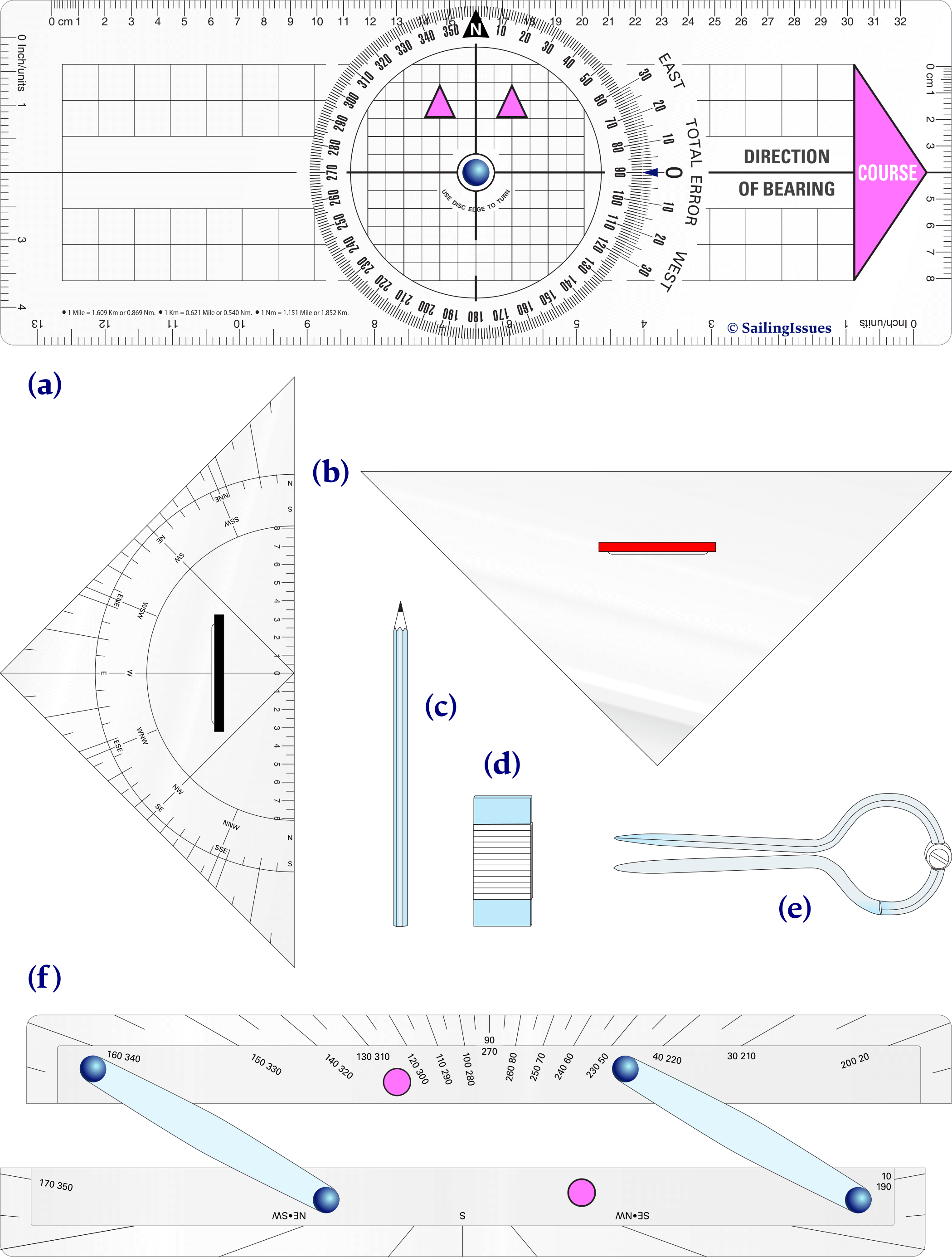
An overview of the chart plotting instruments that we will use in Chapter 2.
(a) Breton plotter
(b) Protractor triangle with supporting triangle on the right
(c) Pencil (2B), hexagonal so they don’t roll away
(d) Eraser (from plastic, since others will smear).
(e) Dividers (single hand version)
(f) Parallel Ruler (Captain Field's improved)
See the next chapter…
- Course overview: goals and introduction
- Positions: latitude, longitude, nautical mile, scale, knots
- Nautical chart: coordinates, positions, courses, chart symbols, projections
- Compass: variation, deviation, true • magnetic • compass courses
- Plotting and piloting: LOPs, (running) fix, dead reckoning, leeway, CTS, CTW, COG
- Advanced piloting: double angle on the bow • four point • special angle fix, distance of horizon, dipping range, vertical sextant angle, radians, estimation of distances
- Astronomical origin of tides: diurnal, semi-diurnal, syzygy, spring, neap, axial tilt Earth, apsidal • nodal precession, declination Moon and Sun, elliptical orbits, lunar nodes
- Tides: tidal height prediction, chart datums, tidal curves, secondary ports
- Tidal streams and currents: diamonds, Course to Steer, Estimated Position
- Aids to navigation: buoys, leading lights, ranges, characteristics, visibility
- Lights and shapes: vessels sailing, anchoring, towing, fishing, NUC, RAM, dredging
Also you can download the exercises + answers PDF ![]()