Patmos sailing holidays
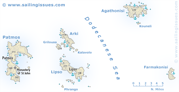
The island of Patmos - Πάτμος and its neighbours form a tranquil miniature cruising area, reasonably close to yacht charter bases in Kos or Paros, Syros or Mykonos.
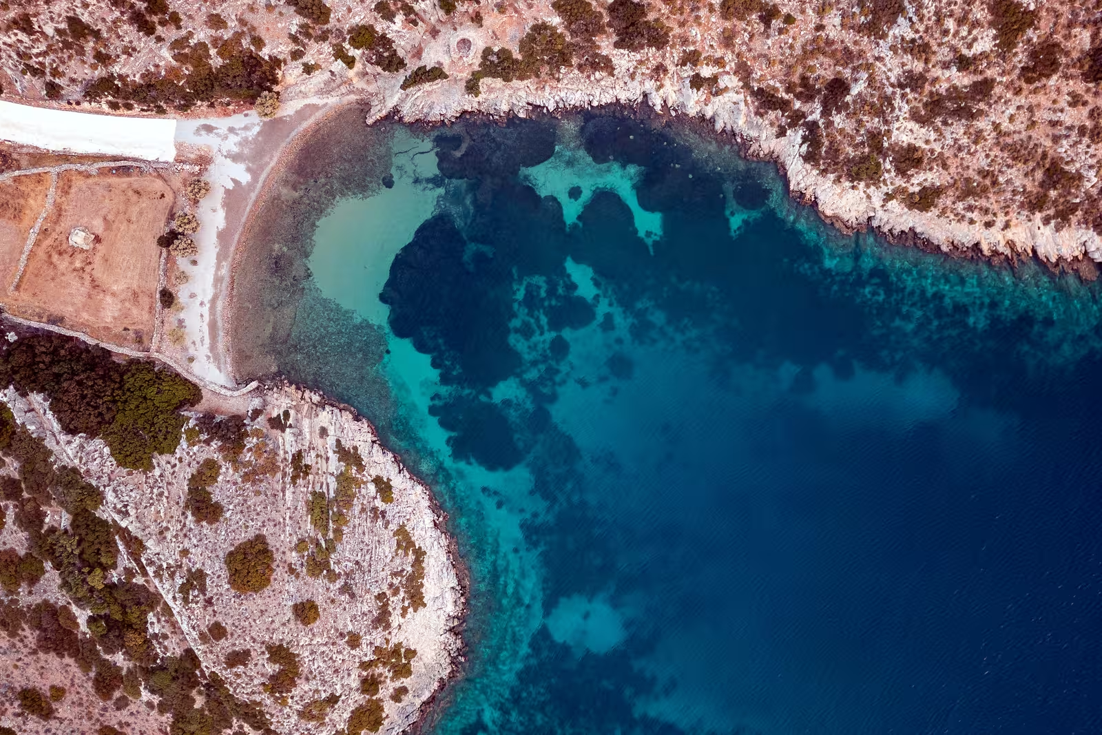
Patmos constitutes – together with the smaller islands Lipsi, Arki, Agathonisi and Farmakonisi – the most northern group of islands in the Dodecanese, and is a rugged island of volcanic origin; perhaps the rim of an ancient caldera. With least 8 quakes above magnitude 6 since 1900 Patmos has a high level of seismic activity.
It has been celebrated since the Middle Ages as the island of St John the Divine, who is said to have written the Book of Revelation while living in exile on Patmos.
- All Greek islands
- Dodecanese • Southern Sporades overview
- Chios
- Samos
- Patmos • Arki • Lipsi
- Leros • Kalymnos
- Kos • Nisyros • Tilos
- Astypalaia
- Symi
- Rhodes
- Itineraries in the Dodecanese, adjacent Turquoise coasts and Southern Sporades.
Previous island: Samos
Next islands: Leros and Kalymnos
Patmos history
Patmos was originally settled by Dorians and later by Ionians, and had a Sanctuary of Artemis. The early history of the island, a place of little or no political or economic importance, is unknown.
Like its mostly barren neighbouring islands, Patmos was used as a place of exile in Roman times. During the early Middle Ages it seems to have been abandoned and desolate.
See these old nautical charts of Patmos.
Since 1946 the whole island of Patmos has been under statutory protection as an ancient monument. The acquisition of land by foreigners and the export of antiquities are prohibited.
The various St Johns
Traditionally, the following Johns are regarded as the same person:
John of Patmos = John the Divine = The author of the Book of Revelation = John the Apostle = John the Evangelist = John the Theologian. circa 6 CE – circa 100 CE)
However, John the Baptist, preacher, ascetic (circa 5 BCE – circa 30 CE), and reported baptizer of Jesus Christ, is a different Saint.
Patmos island ↻
- Patmos port • Skala
- Groikos • Kallikatsou
- Psili Ammos
- Stavros (Diakofti)
- Merikas
- Lefkes
- Ag Nikolaos
- Kalogiron
- Lampis
- Livadi
- Kampos
- Agriolivado
- Meli
Arki island ↻
Lipsi island ↻
- Lipsi port
- Lientou • Kampos • Christos
- Moschato
- Platis Gialos
- Aspronisi
- Kouloura (Chochlakoura)
- Katsadia
- Lyra islet • Papandria
- Chalavra (Makronisi)
Agathonisi island ↻
Farmakonisi island
- no-go Farmakonisi

Ports / anchorages are clickable .
British Admiralty Charts 1056, 1531. signifies a highly recommended venue, and a truly must-see venue; see other icons.
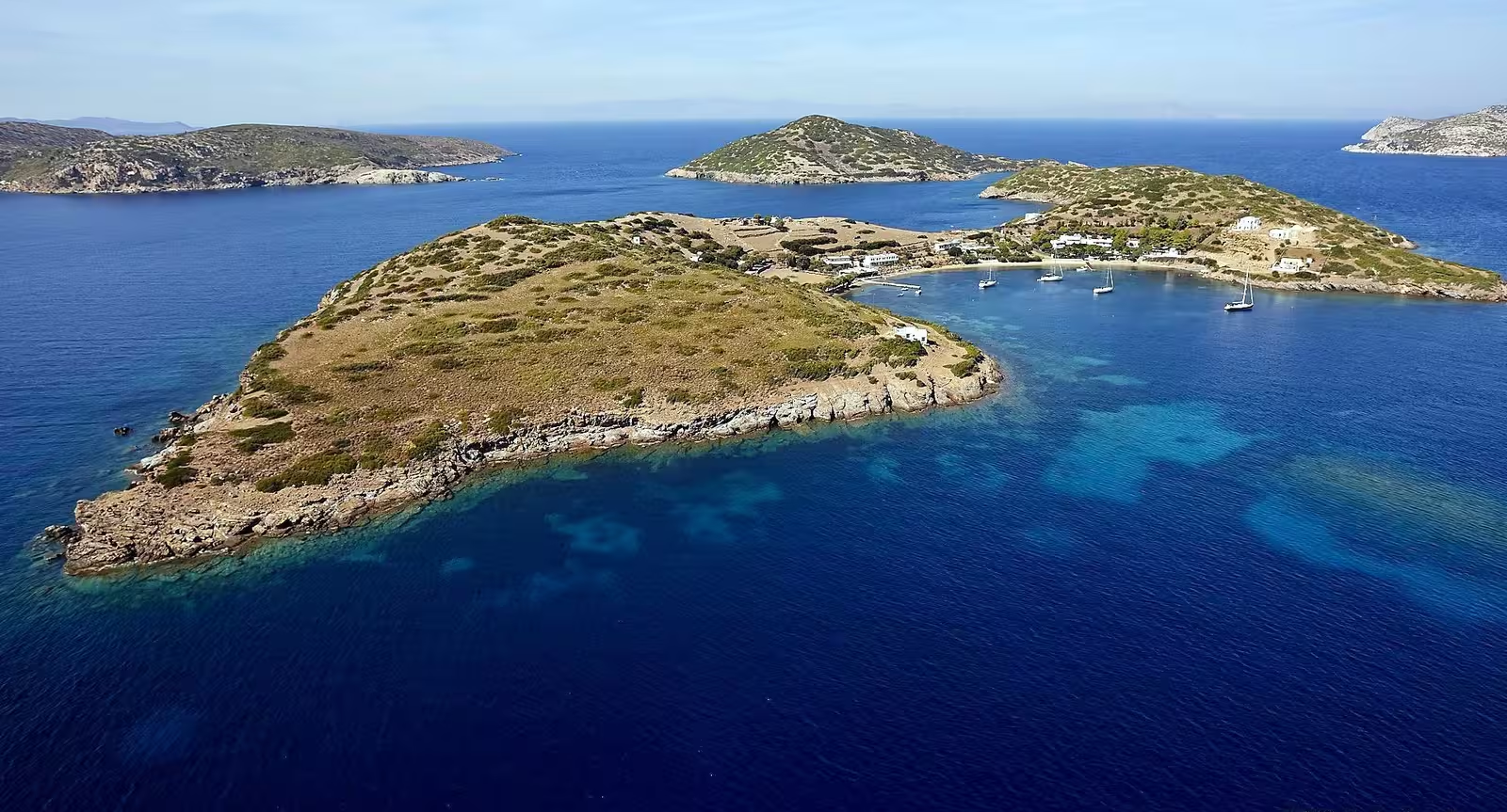
Patmos island
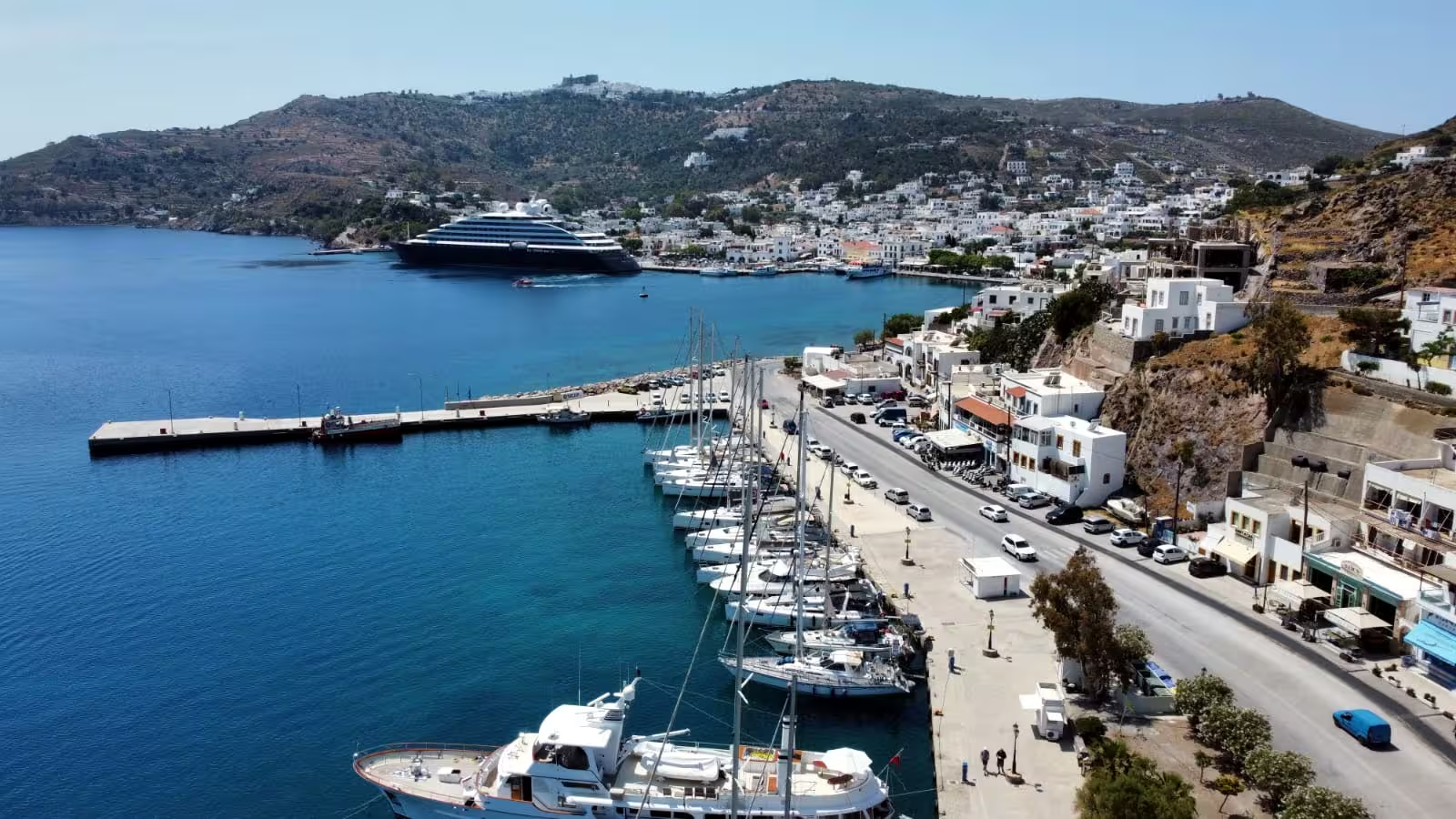
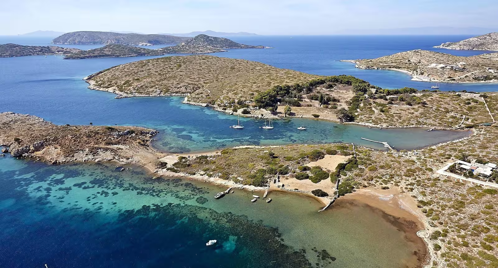
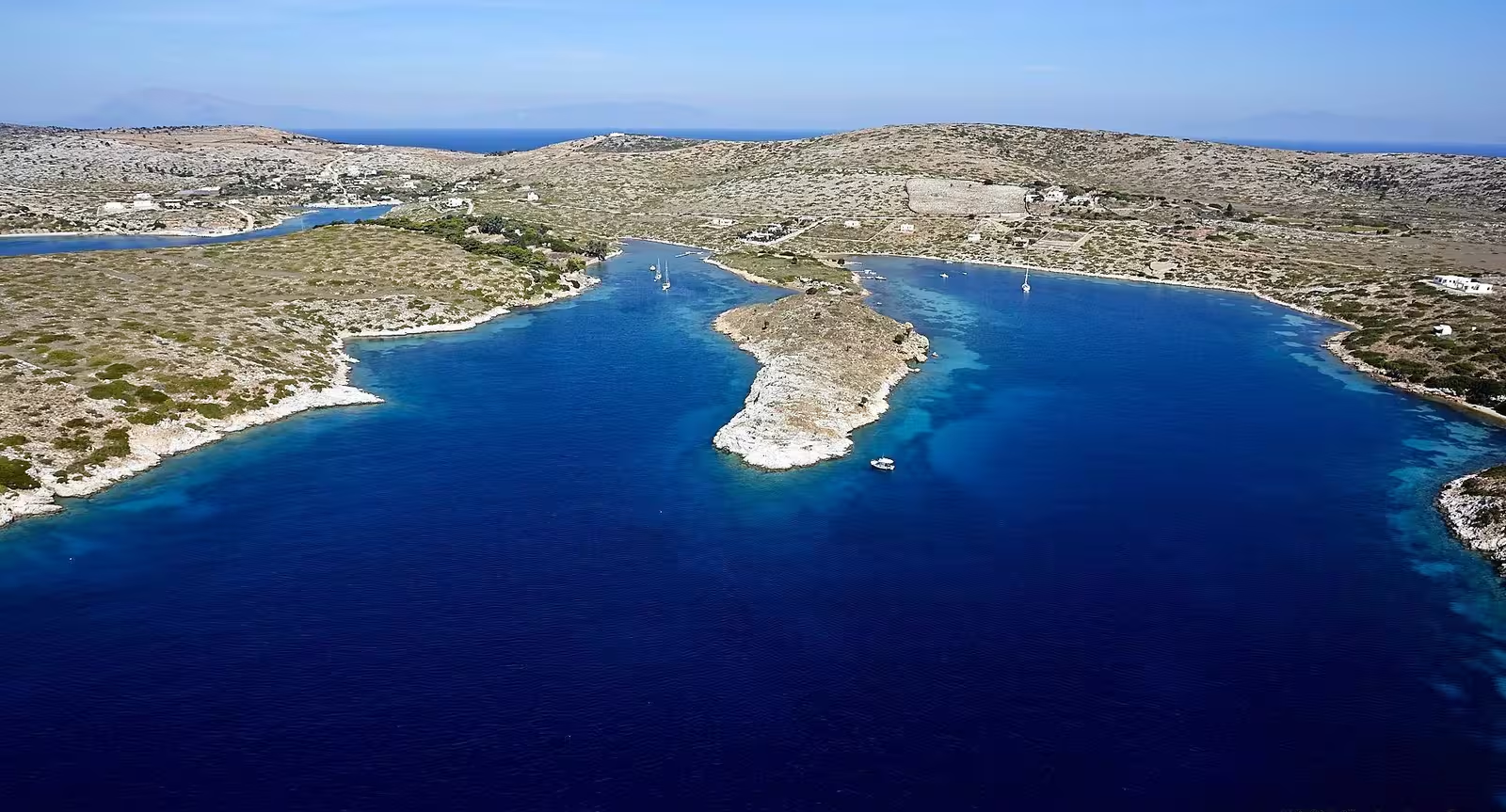
Patmos port • Skala
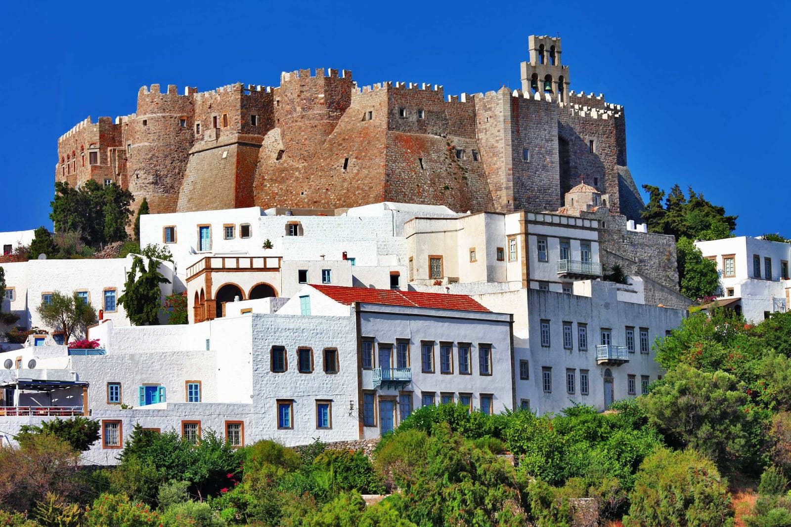
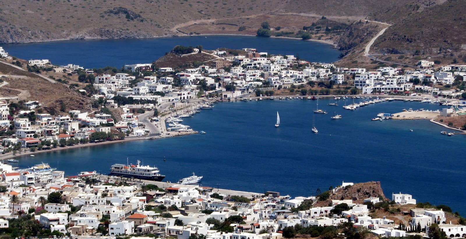
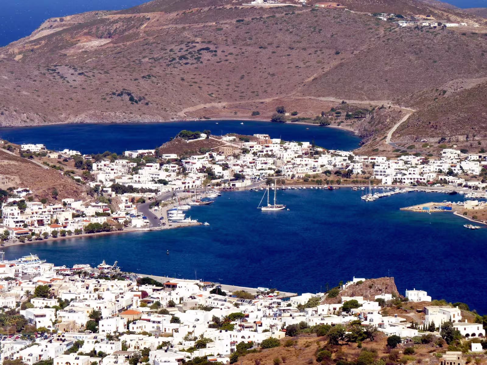
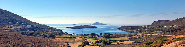
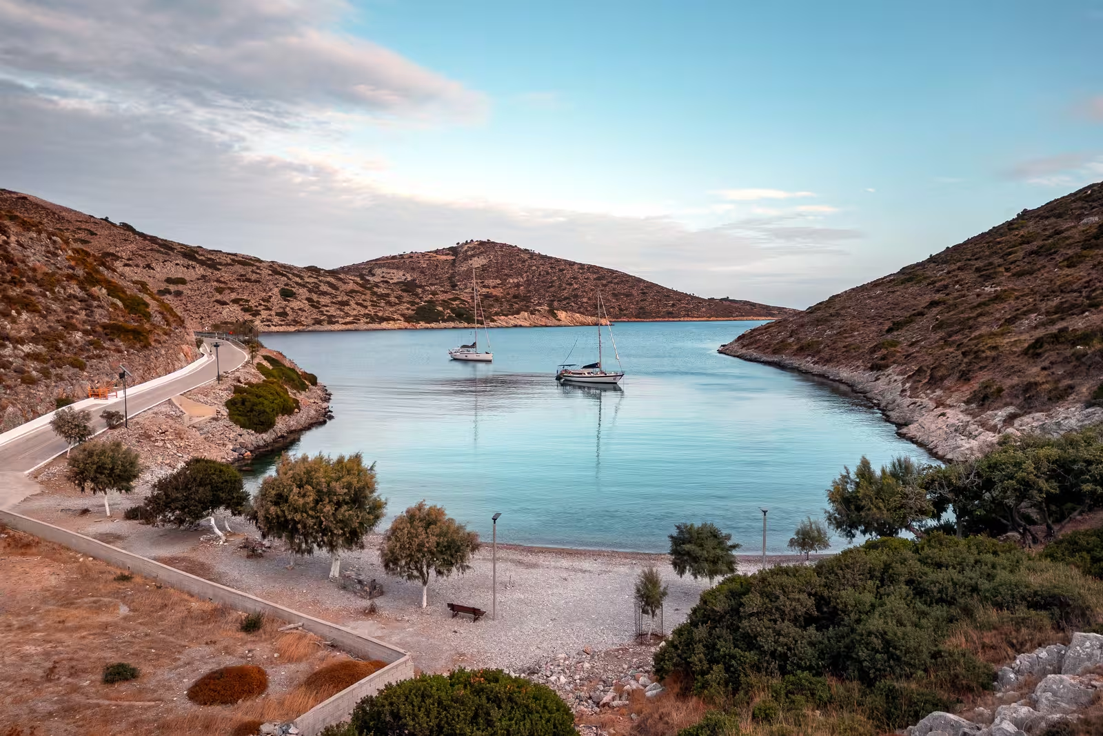
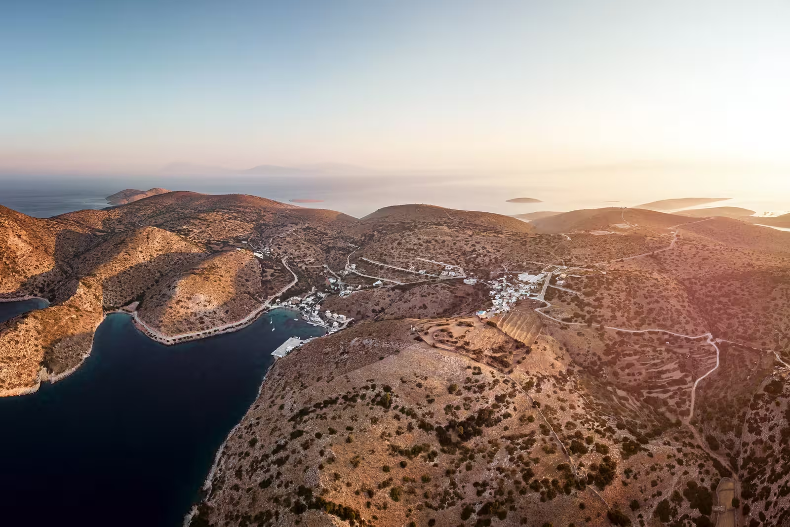
Pátmos port and Skála - Λιμάνι Πάτμου και Σκάλα is the ferry port of Patmos. Above it towers Chora with the monumental Monastery of St John, one of the most important pilgrimage sites of the Greek Orthodox Church. It is presumed that here John of Patmos received the vision found in the Book of Revelation (Apocalypse), and where the book was written. Built around the Castle that protects the Holy Monastery is Chora, the island's capital and UNESCO World Heritage Site with 612 permanent residents.
A large blue freighter delivering water docks in the NW corner and is one of the reasons that anchoring in the bay is not always allowed.
This leaves 3 main options:
- The west quay.
This waterfront offers room to 50+ vessels, but mind that in July and August all these berths will be occupied by 11:00.
Since there are no lazy lines installed, the mediterranean mooring is done at anchor, and in the prevalent cross-winds the anchors are (sometimes deliberately) dropped upwind of the berths resulting in chaos and anchor spaghetti; good holding in muddy sand; use plenty of scope.
The white rectangular kiosk (κιόσκι) located at the bend houses the harbour official who will assign you a berth; note that he will also collect a €3 line handling fee even when not required.
Fortunately, outside the main yacht charter season you can blissfully go alongside.
There are electricity and water pillars all along the waterfront;
fierce gusts are from the NW – N; no swell except in SE winds; the typical strong cross-winds can be dangerous, both during docking and once-docked, therefore spring lines are often deployed from the port-side mid cleats.
The local power station is situated at the NW corner of the bay and its generators run on diesel. Since the prevailing wind is on the beam, the utmost nuisance was engineered and nauseating and poisonous fumes will penetrate all vessels 24 / 7.
The section of the quay just north of the bend suffers rather less from the diesel exhaust, the section south of the bend is usually reserved for Coast Guard, Navy, etc., but when docking is allowed here, it becomes the premium spot.
Register for free and join an active, critical sailing community.
Near the base of the breakwater you will find “Sam's Cafe/Bakery” for vital morning coffees; also nearby is the Eco-laundry service; Proton supermarket delivers to your yacht; you can shower for €5 at Hotel Australis, public toilets at the “marina”.
Skala village is a delight, yet while the quayside received a cosmetic treatment in 2024 – 25 it is nowhere near as enticing as e.g. Ios port, Astypalaia port or Symi port.
From Skala, a wide and attractive footpath brings you to the Cave of the Apocalypse, then up to the Monastery at the summit.

The ferries and cruise ships that frequent the commercial quay can cause an unsafe swell on the outside of the breakwater. On the inside it is safe to go alongside.
- The breakwater – extension completed in December 2021.
On the inside (north), which is a lee-shore in the prevailing winds, you can go along-side.
On the outside (south) you will have to be careful with the wash of cruise ships and ferries, so mooring stern-to is recommeded. The stern-lines will take the force of the winds.

- The “Patmos Yacht Marina” in the NE of Skala bay.
On the quay NNE, inside the basin, there might be a few stern-to berths for visiting yachts, although mind the reserved spots for local boats.
Likely you will want to stay on the pontoon (inside or outside); very secure with all-round protection except strong southerlies; moor alongside; especially near the red harbour light there is space for visitors, we have never seen yachts rafting up.
Electricity and water available at all berths; public toilets in the NE corner of the basin. Dinner at restaurant “Netia“.

Tragonisi (Tragos) islet left is guarding the bay.
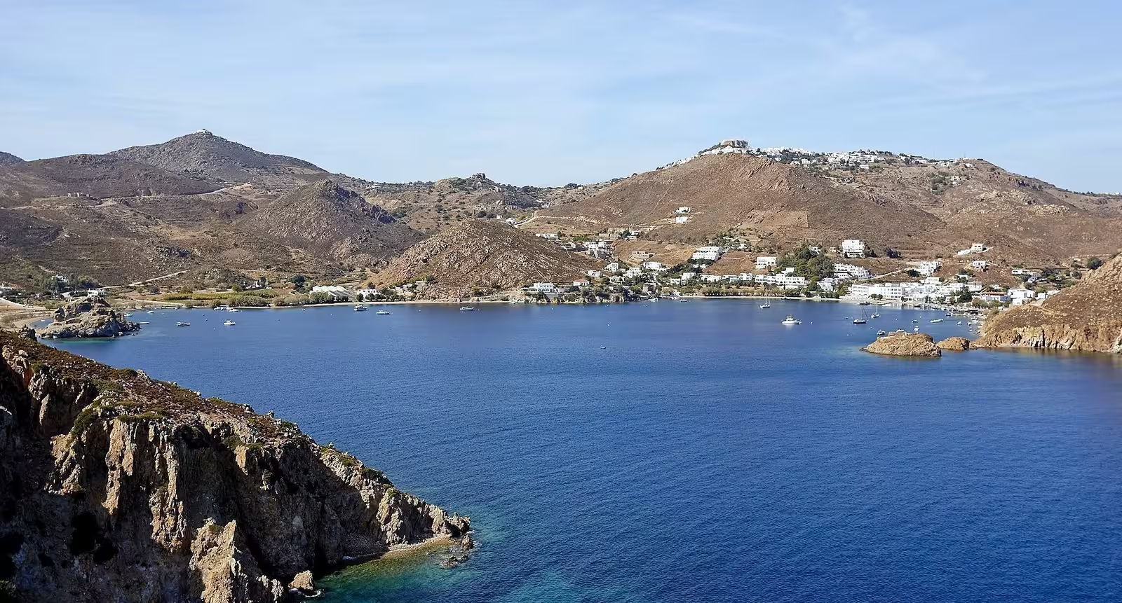
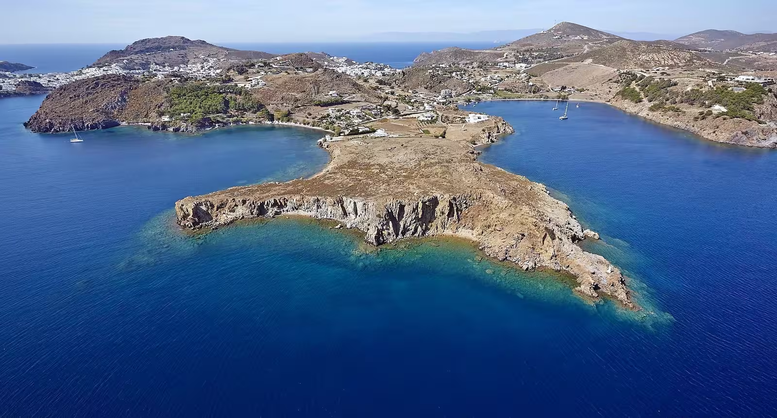
Groikos (Grikos) • Kallikatsou
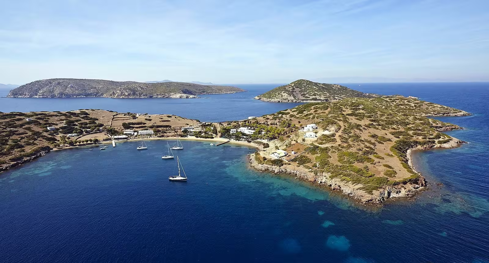
The bay of Groíkos (Gríkos) - Γροίκος is the second gateway to Chora, with a splendid view of the fortified Monastery up in the distance.

The T-shaped pier can fit a few yachts, yet depths are only 2.5 m at the very tip and <1.8 m alongside, so not useful for most vessels;
also mind the myriad permanent moorings (daytrip boats): a tripline is recommended.
The pre-existing option of using a mooring buoy (14 buoys on either side) is defunct: the buoys are no longer maintained and cannot be fully trusted (2025 season). Hopefully, they breath new life into the previous mooring buoys service. For the moment you might get lucky and use the secure buoy from Stamatis Restaurant tel: +30 224 703 1302.
Gusts NW (strong); good holding in the shallow rim, 4-7 m over sand, Lat Long; steep seabed, even quite close (±80) to the shore you are already in 15+ m of depth.
The hamlet has no shops just a few restaurants and a pizzeria, there is “Ktima Petra” if you follow the coast south for more authentic dining.
3 notable dangers: If. Chélia, unlit; Kavourounísia, lit and the southernmost point of Patmos where there is a reef extending from Cape Prasóvouno.
Note that with a mooring buoy the bay of Grikos is more desirable than Skala. No ferries and no hordes of pelgrims and tourists.
Directly south of Grikos and north of the cape and rock of Kallikatsoú - Καλικατσού there is an alternative anchorage if Groikos is too crowded. Again lots of (derelict) mooring buoys, nearly all will be marked private anyway; difficult to anchor due to weeds and discarded moorings.
Visit the traditional wooden ship boatyard to the south.
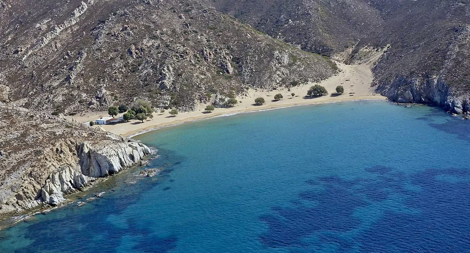
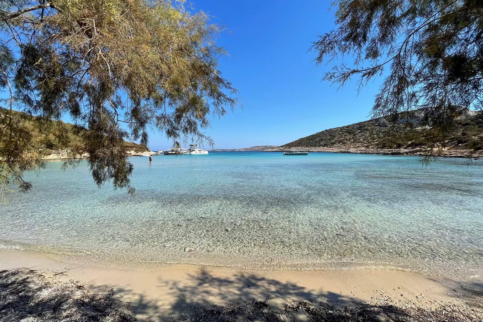
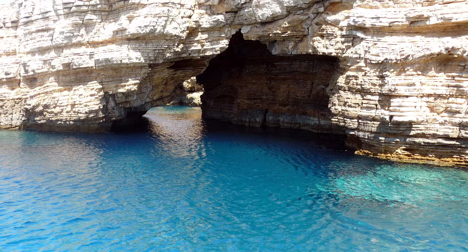
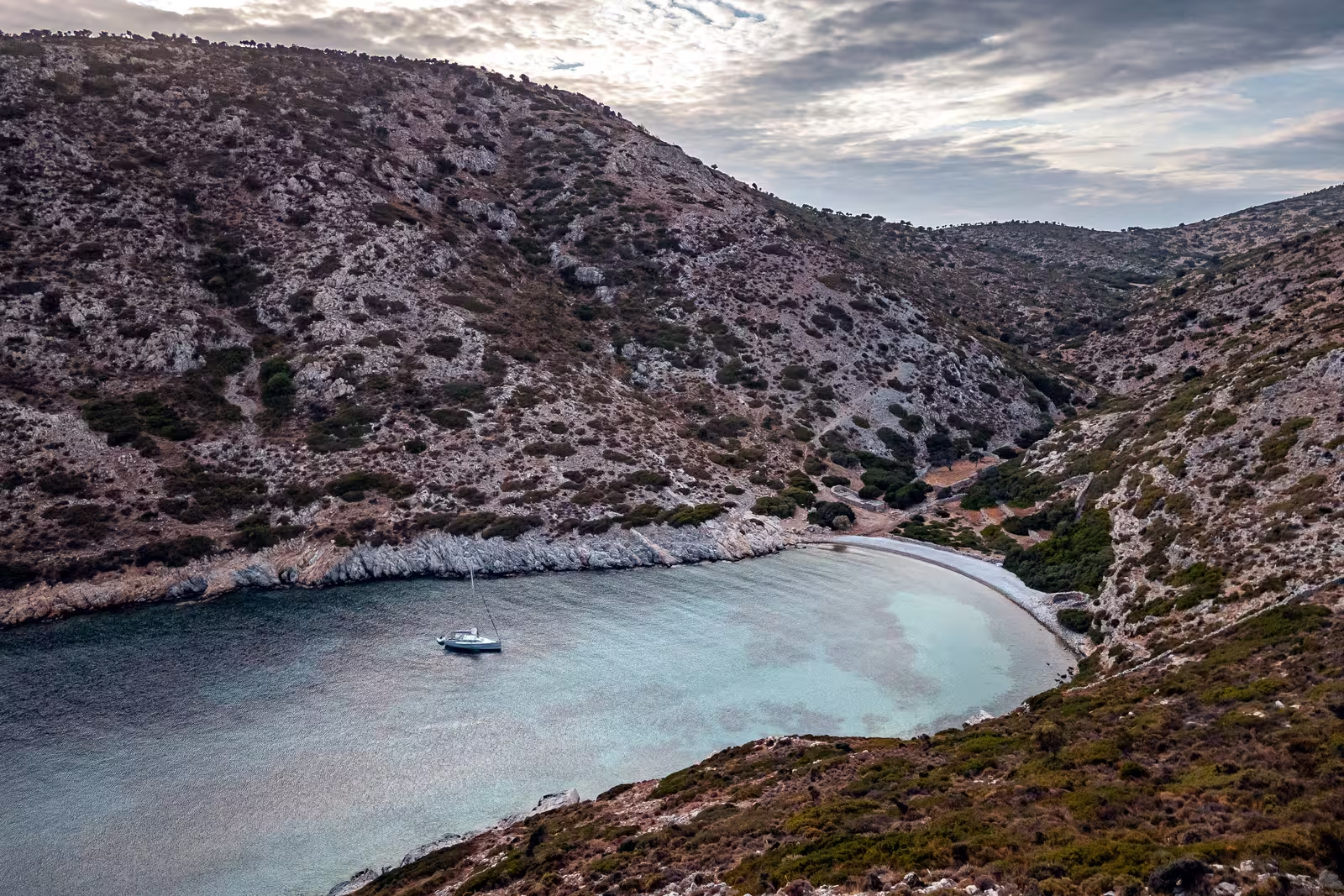
Psili Ammos
Psilí Ámmos - Ψιλή Άμμος is an eye-catching anchorage and beach with fine sand, tamarisk trees for shade and donkeys. Unfrequented since it lacks a hardened road. Alluring snorkeling at the rock formations on either side.
Anchor in 3 – 5 m over a large sandy patch, Lat Long , excellent holding. Open to SSW – NNW winds.
“Greek tavern” ashore.
Stavros (Diakofti)
Stavrós (Diakófti) - Σταυρός (Διακόφτι) is a extensive and unremarkable bay overgrown with weed; difficult anchorages; confusingly Diakofti and Stavros are used for different venues in different guides…, but there are three options (as officially named):
- Mikri Psili Ammos - Μικρή Ψιλή Άμμος is in the south, Lat Long, and is quite stunning with a glorious deserted beach surrounded by rock formations, good holding in sand if you can penetrate the weeds, so certainly for a lunch-stop you should make an attempt.
- Diakofti beach - Παραλία Διακοφτη is in the east; anchor north of the beach, Lat Long. Note that Diakofti bay is actually at the other side of the isthmus: between the SW coast of Tragos islet and Patmos, where you can find a chandler and other marine services.
- Stavros - Σταυρός is in the north, Lat Long, and offers the best protection in NW winds; some katabatic gusts from Mt Diavolo.
Greek terms / names: Stavros means “Cross”.
Merikas
Mérikas - Μέρικας is an featureless bay exposed to westerlies, although some protection against NW winds, anchor over sand / pebbles, Lat Long.
Lefkes
Lefkés - Λευκές is open from NNW – WSW and therefore rarely useful with the prevailing winds. In the middle in front of the beach is a nice sandy area with solid holding, Lat Long. Small disembarkation pier on the south side; in the holiday months the “Cantina Lefkes” opens it doors for non-vegetarians, visit the watchtower, beautiful sunsets.
Ag Nikolaos
The wide bay of Ágios Nikólaos - Άγιος Νικόλαος is open to NW – ESE winds, although you can squeeze in tight under the west shore to get some protection against NW winds. Solid holding in sand (small pebbles), Lat Long; buy fish directly from the fishermen that keep there boats on the north side; nothing ashore except further inland the homonymous Chapel of Ag Nikolaos; no phone signal.
Kalogiron
Kalogíron - Λιβάδι Καλογήρων is the tiny bay and fishing harbour immediately east.
This tight spot is open to WSW – NNW (i.e. the prevailing) winds, with room for just one or possibly two vessels, Lat Long.
Ashore on the opposite side of the shallow fishing harbour you will find the fine fish restaurant “Λιβάδι Καλογήρων”, also tour the local
Monastery / hermitage.
The bay looks out to Ánidro islet (87 m), in front of Ikaria (1035 m) protruding from beyond the horizon.
Lampis
The bay and beach of Lámpis - Λάμπης aka “Paralia Lampi” offers clear water over sand, but is only useful in southerlies and is not particularly pretty, Lat Long; any NW gusts are rare; ashore “Taverna Lampi”; 2 wind turbines dominate Cape Fyrós (Kókkina); south of the wind turbines is a <20 m mole (pointing ±south) only correctly shown on Garmin and not shown on Imray, OSM, C-MAP or Eagleray. Mind the submarine cable.

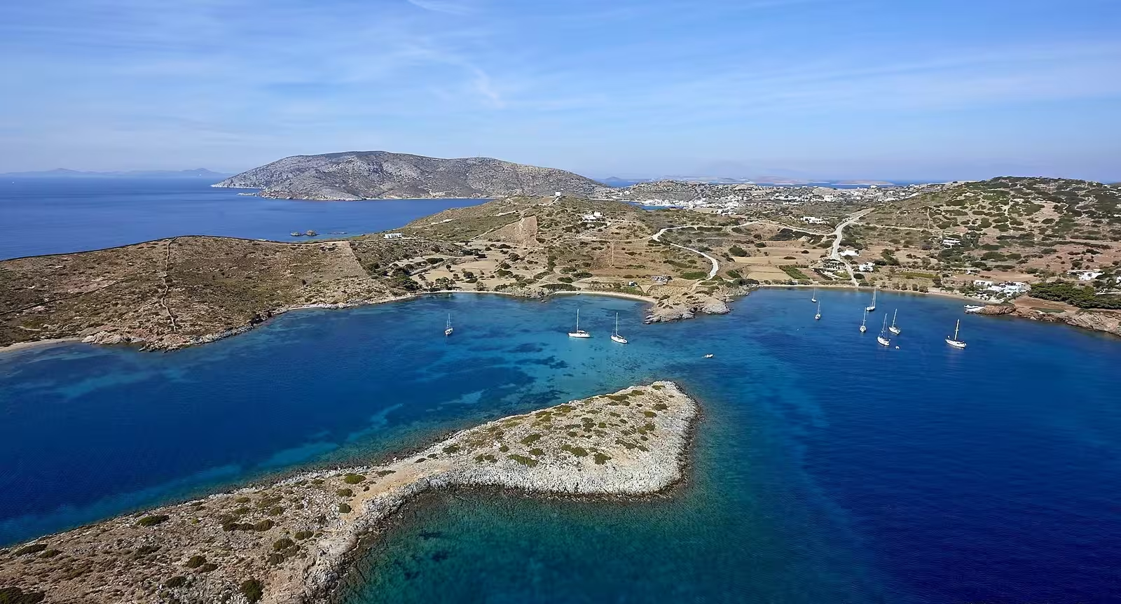
Livadi
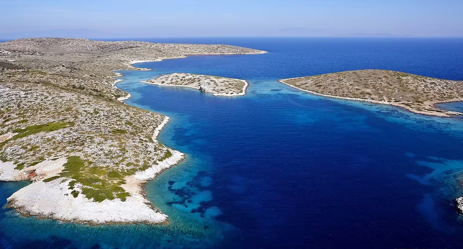
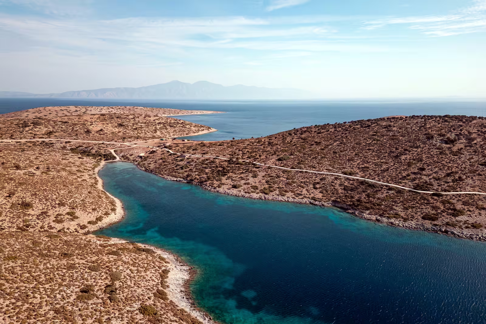
The wonderful bay of Livadi - Λιβάδι is protected in NNW – ESE winds but is certainly an option in lighter southerlies since the anchorage is shielded by Ag Geórgios on the south and the smaller Koúdros/Kentronísi islet on the SE and the capes Trypití and Geranós to the east.
Good holding over sand in 4 – 8 metres, Lat Long, but mind there are some shallow sand areas with flat rocks underneath.
Ashore you will find “Livadi Geranou” a family restaurant without an organized beach with sun beds and parasols, no music or motorised water sports to disturb the bliss.
Note the reefs that connect the isles of Ag Georgios and Koudros (Kentronisi) islet to Patmos, see photo below; enter the anchorage at 25° keeping closer to Ag Georgios.

with Ag Georgios island on the right and Chelia (104 m) in between further.
Behind Cape Trypiti from the left is Leros island on the horizon. Hi-res image
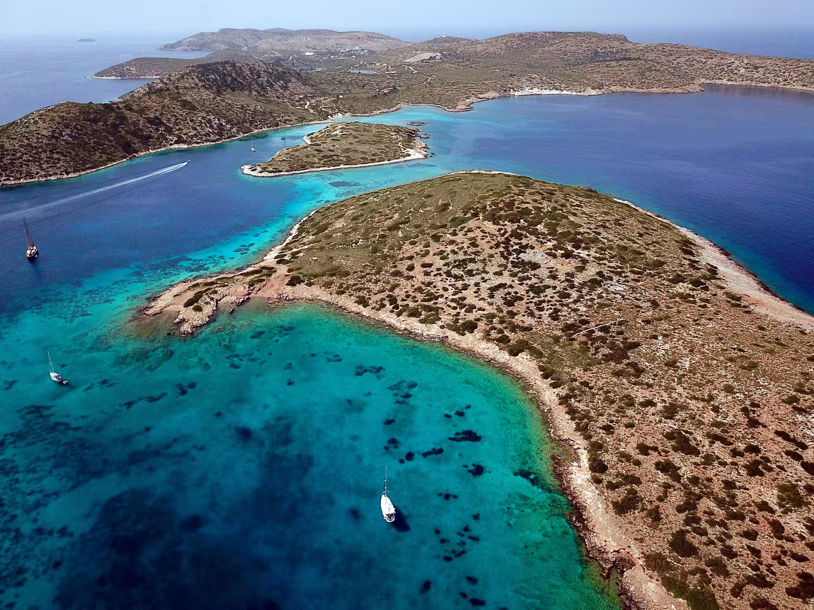
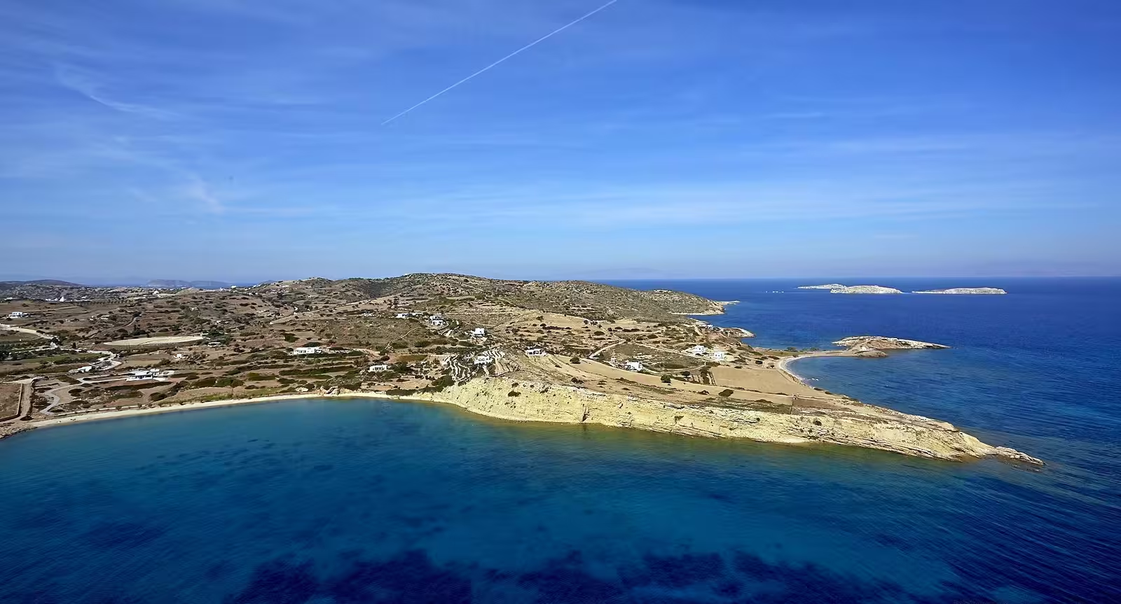
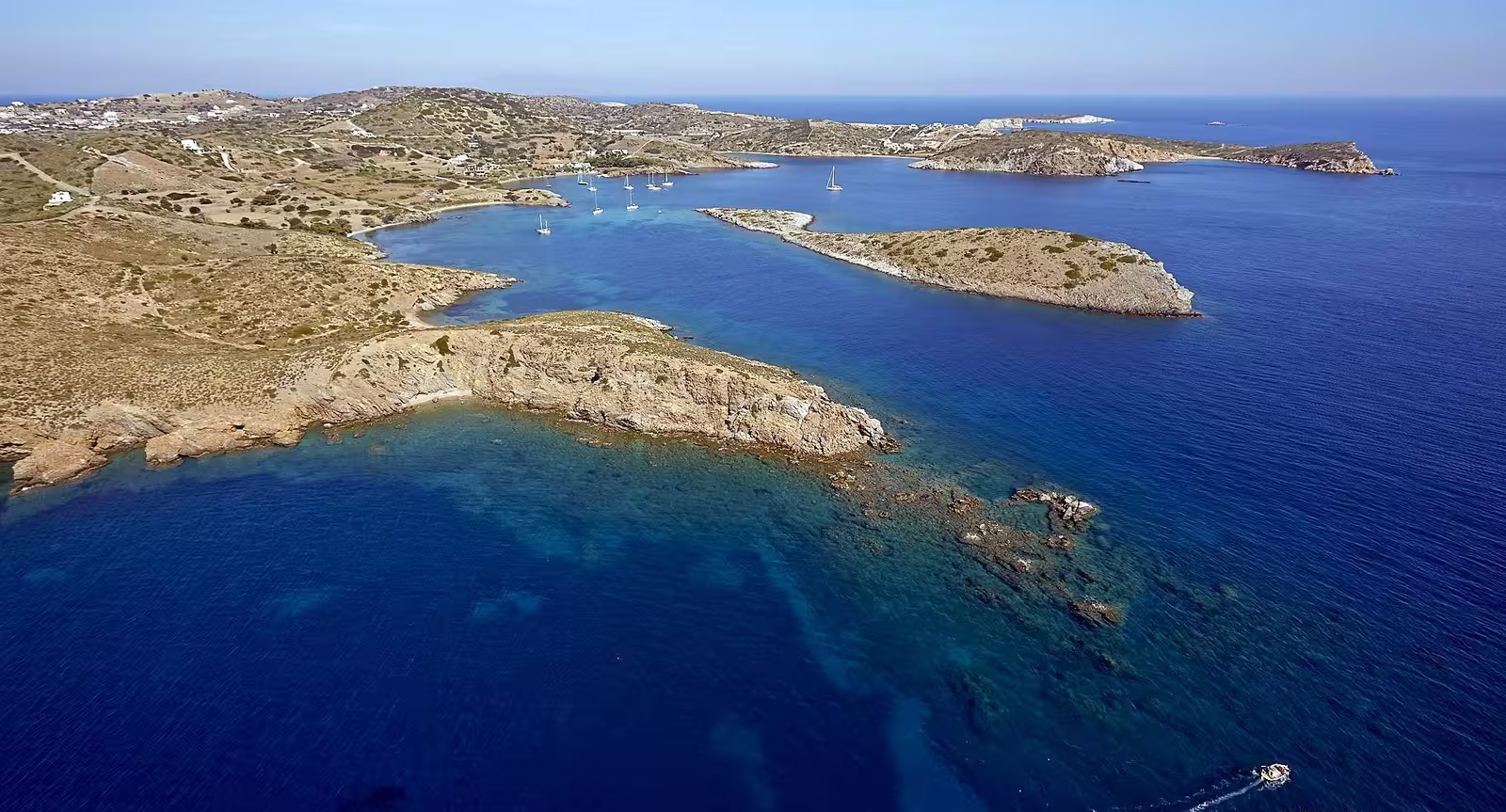
Kampos
The bay of Kámpos - Κάμπος, mis-transliterated in the Greek Waters Pilot as Kambos, which would originate from “Καμμπος” (although historical Italian charts do show this bay as Ormos Kambou), is open to E – SSE winds, reasonable holding in sand in 5 – 10 m depths outside the swimming area, Lat Long.
The anchorage suffers from a bit of traffic noise, plus a speedboat with an insufferable driver (pulling inflatables or water skis) will cause big waves since he steers his “fun ride” between the anchored vessels, only during the summer holidays though; disreputable restaurant and mini-disembarkation pier.
Higher up is Pano Kampos. one of the four main villages, and the development around the beach is Kato Kampos.
with Chelia island (104 m) and Sklava(kia) islet+reef behind Ag Thecla islet (23 m),
and with Lipsi on the horizon Hi-res image
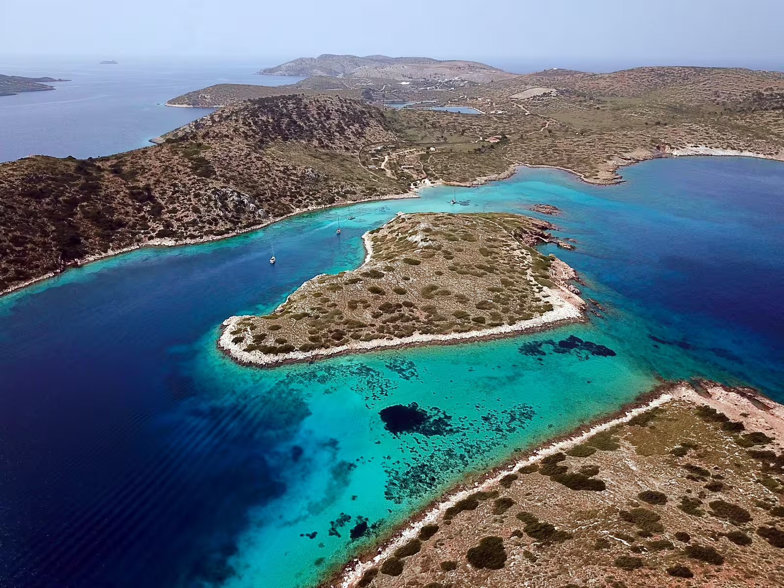
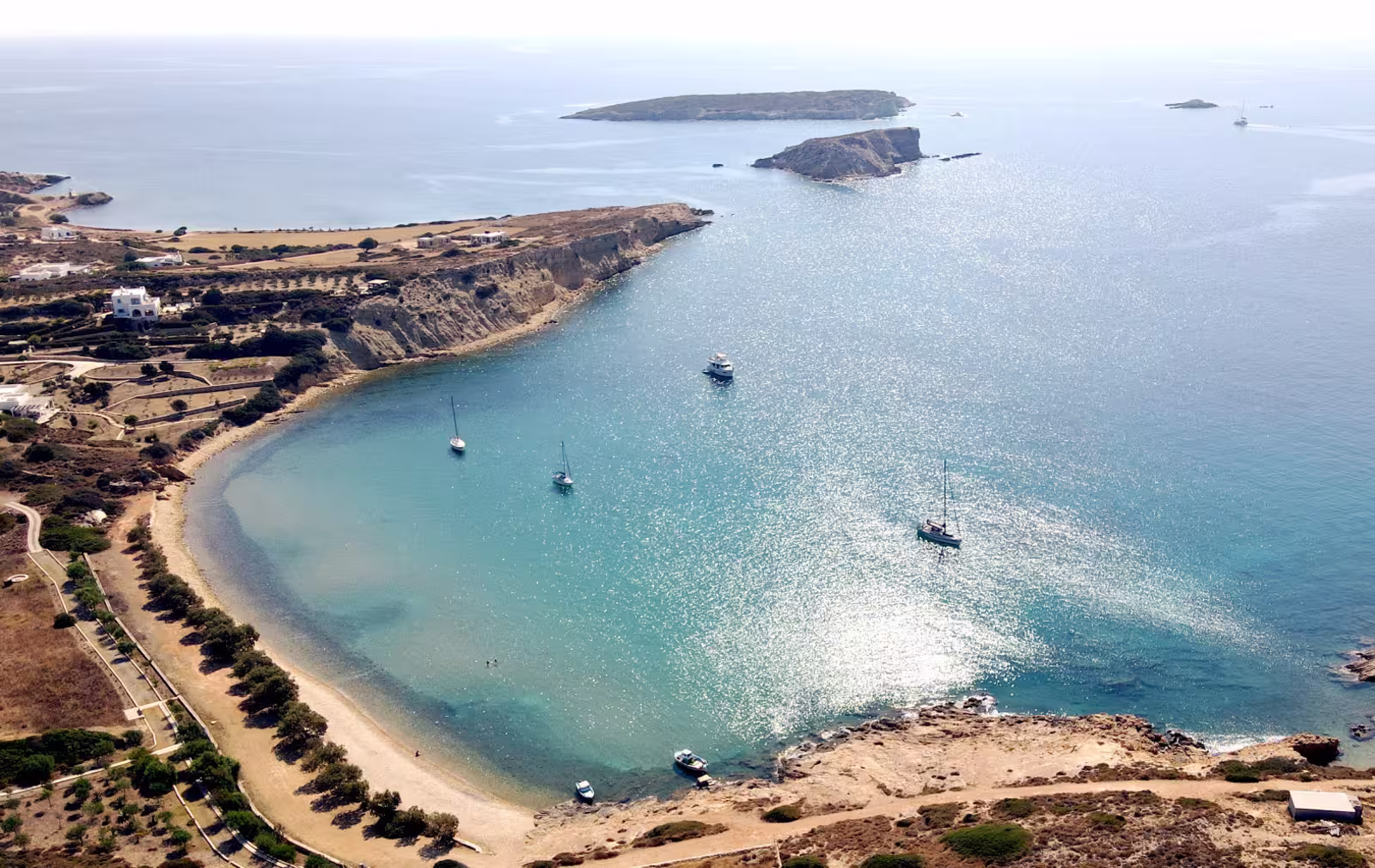
Agriolivado
The pleasing cove of Agriolívado - Αγριολίβαδο is guarded by the islet of Agia Thekla and
is open to NNE – SSW, but provides perfect shelter from the prevailing NW winds.
Popular sandy beach and restaurant ashore; in the summer months reckless and dinning speed boats and jet-skis can ruin the atmosphere; after turbulence the water becomes opaque and the bay loses some of its charm; for snorkeling, aim for the rocks and reefs near the north shore.
Anchor close to the buoys that mark the swimming area, pref. in the NW area although you should mind the flat rocks / hard sand there, otherwise in middle; seabed is mostly sand; Lat Long. Prepare for beach music (till midnight) in the high season.
The rumoured mooring buoys were not present (May 2024, July 2025); small disembarkation pier for the dinghy.
Meli (Meloi)
To the north of Capes Aspri and Vamvakiás is the lovely bay of Méli (Melói) - Μελόϊ while to the south is a smaller unnamed bay (usually called To Kyma after the restaurant). Although these seem pretty useful spill-over anchorages when Skala is too crowded, the holding is suspect [understatement] even when you are able to penetrate the thick carpets of weeds. Aim for the meagre sandy patches in the northern section in 5 – 10 m, Lat Long; mostly weed, a bit of sand (pebbles) but also muddy clay; suitable for lunch-stops only. Both bays feature a taverna; Meli: possible to take a line to the disembarkation pier or to the rocks on the south side; lots of donkeys roaming about.; To Kyma: Turkish gulets and superyachts anchor here to offer their guests privacy.
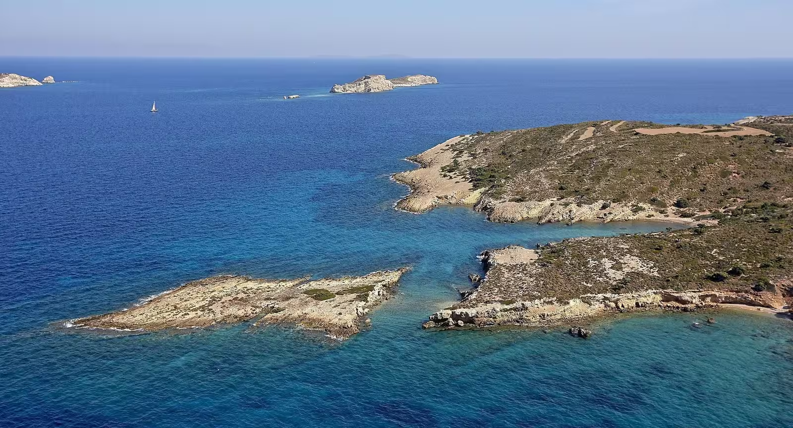
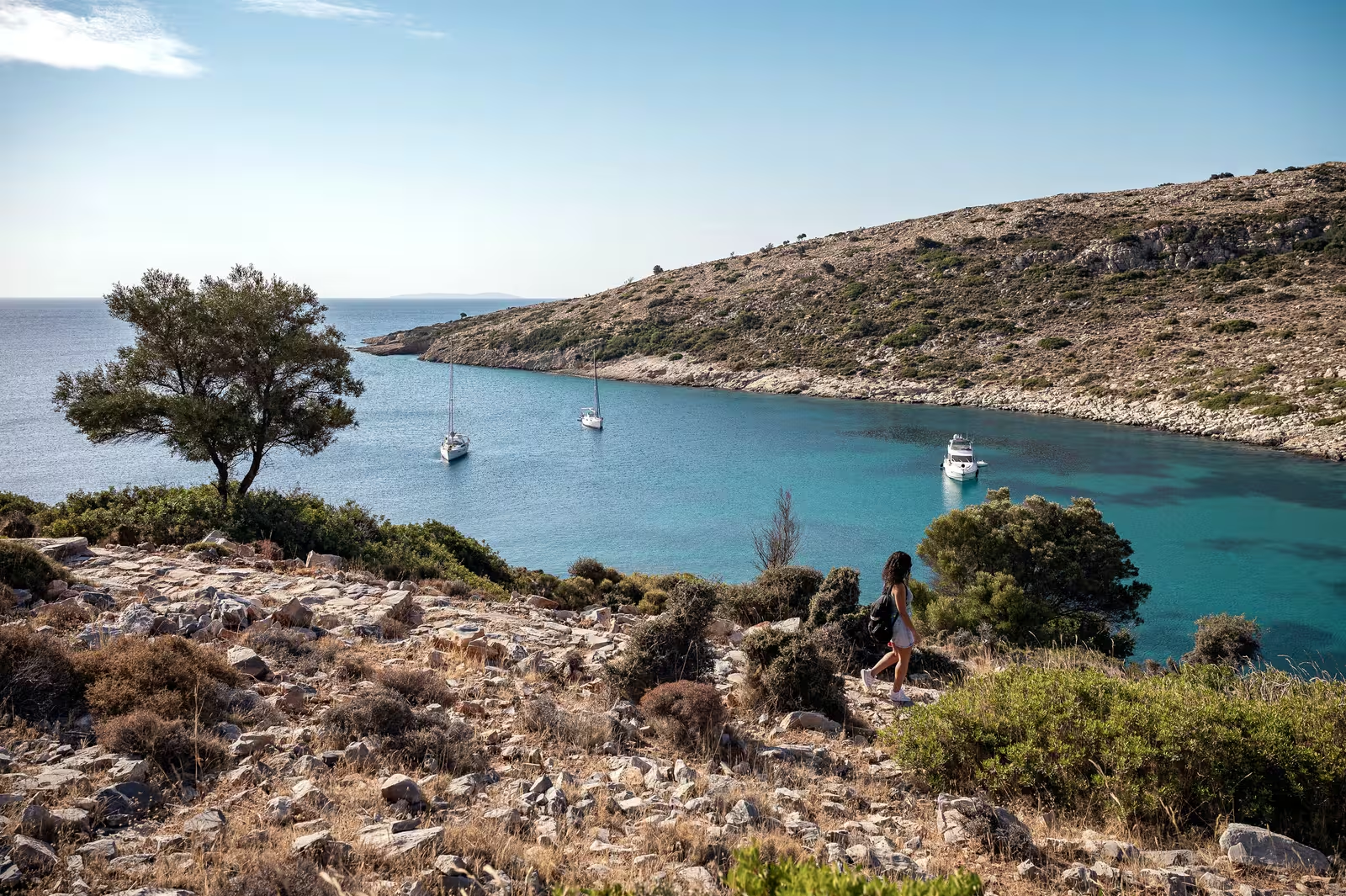
Arki island
Arkí - Αρκοί reaches a height of just 110 m and is made of limestone from the Oligocene. The vegetation of the island and of the surrounding islets is characterized by drought and grazing and lies in the thermo-Mediterranean high altitude zone: a Mediterranean climate characterized by hot summers and short, mild winters.
For management purposes, the plots of land are divided into two sections and are grazed alternately every one to two years.
The local phrygana notably includes thorny burnet Sarcopoterium spinosum, conehead thyme Coridothymus capitatus, greek spiny spurge Euphorbia acanthothamnos, small-flowered cistrose Cistus parviflorus, Daphne gnidioides and Teucrium capitatum together with isolated mastic-shrubs Pistacia lentiscus and wild olive-trees.
Only in a few places do the latter two shrubs and the carob tree Ceratonia siliqua join together to form a denser maquis (macchia) shrubland.
So far, 340 species of fern and seed plants have been found on Arki and the surrounding islands, and 259 on the main island alone.
These relatively small numbers are explained by the small size of the island and the limited biodiversity.
Remarkable species are Aristolochia parvifolia, spotted arum Arum dioscoridis, Garidella nigellalastrum, grape hyacinth Muscari macrocarpum and Romulea tempskyana.
On the smaller islets, the composition of the flora has a larger random component than on larger land masses, which creates opportunities for low-competitive small island specialists. Such species in the small islands around Arki are Arenaria aegaea, Allium commutatum and the tree mallow Malva arborea.
Note that C-MAP switches the names of the following islets:
Makronisi → Isola Longo
Avaptisto → Makronisi
Smyntronisi / Sminero / Smyneronisi → Isola della Morene
Porto Augusta
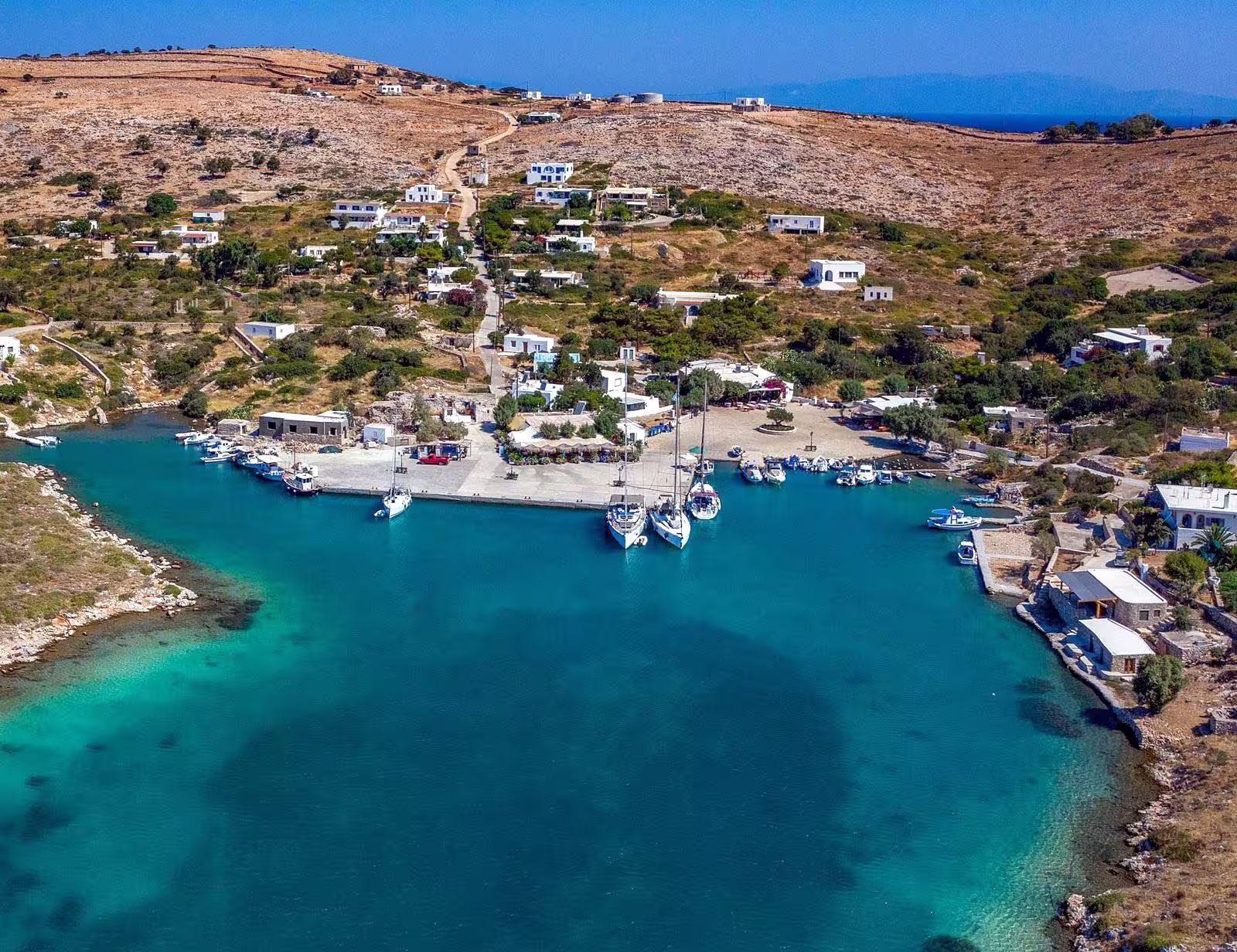
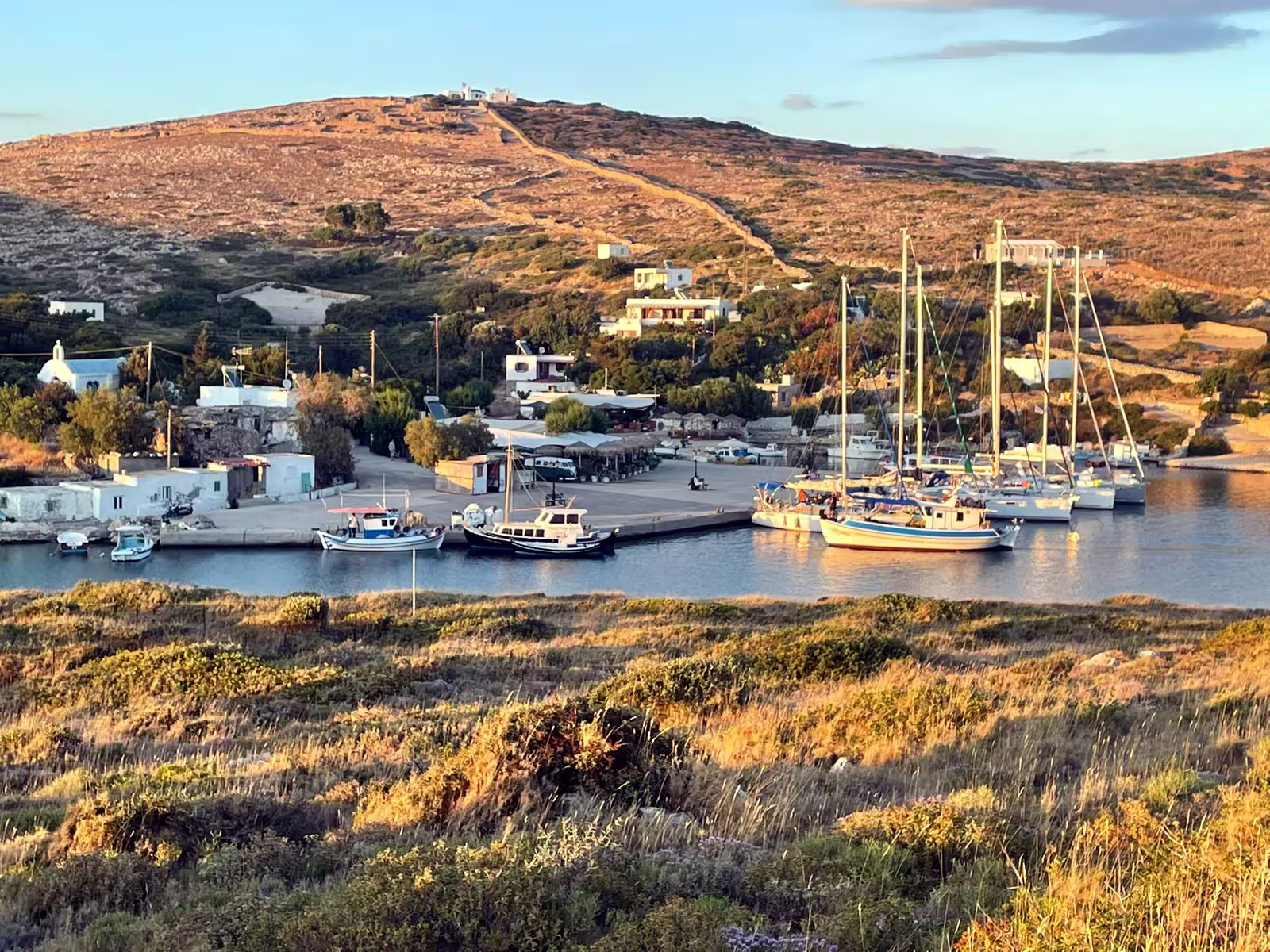
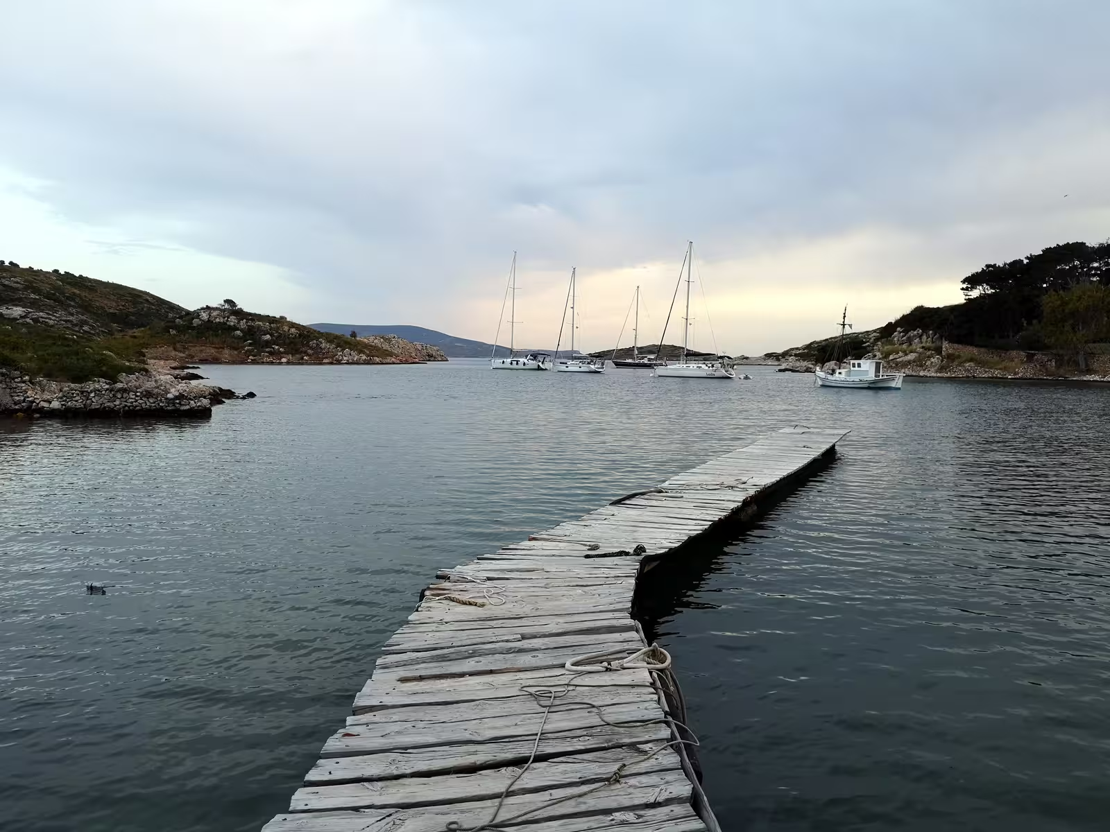
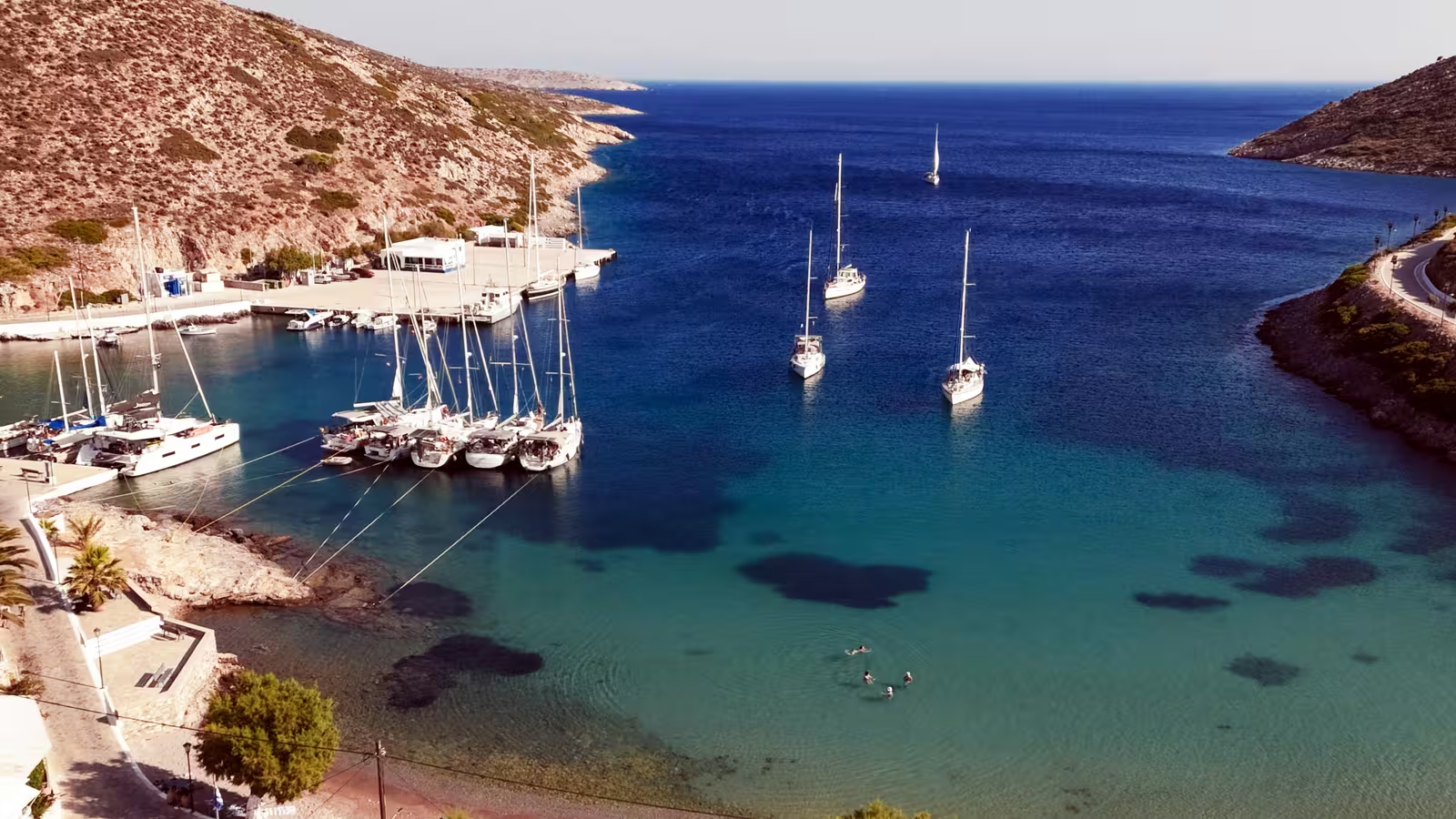
Arki Port aka Porto Augústa - Αυγούστα is natural harbour with all-round protection,
with its entrance quarded by the islets of Marathos, Strongýli (Στρογϳύλη) and Agrylloúsa/Grylloúsa/Agreloússa (Αγρυλλούσα/Γρυλλούσα/Αργελούσσα).
This authentic fishing port is home to just a few dozen inhabitants (40+ on the island in total), and turns from sleepy in the off-season to overrun in the summer months.
At the end of Porto Augusta's deep inlet you will find the town quay which fits 6 – 10 berths depending on how many catamarans are docked. On the approach mind the dangerous shoal opposite the west end of the quay, ±45 meters out from the quay.

Go stern-to the – rather low ! – concrete quay, preferably in the middle or east sections where there are depths of 2.5 – 2.9 m. The west extremity lacks sufficient depths and is only suited to catamarans; what's more, only a short scope is possible due to the rocks straight ahead from here. In case you have a shallow draft try mooring alongside the SW facing quay.
Likewise the local fishermen will sometimes allow you to dock alongside the east facing quay, assuming that you don't block the slipway.
Good holding in sand – mud and some weed; no swell; fully Meltemi-proof.
Although there are very few amenities, you will find clean showers in the white building near the square, free for us yet reportedly €5.
There is no water or electricity on the quay, also no assistence: mooring is free of charge.
In August and surrounding weeks aim to arrive well before noon to secure a berth.
When you find no room at the quayside, you will have to take a line ashore (Turkish style aka Greek style) on the west side, while making sure not to block the fishermen.
From the olive tree on the square you can spot the three tavernas, all excellent, of which the family-run “Taverna Nikolas” is our favourite (child friendly); all three are closed from end of October till early May. The other establishments are merely tourist traps for the ferry hopping travellers and beach enthusiasts.
Fresh fruit and vegetables are only available when the ferry arrives, Arki has no bakery and its former mini-market is permanently closed. However, you might be able to buy bread from the restaurants and delectable fresh cheese from a shepherd (hike up the hill untill the end of the road).
So, since you will find extremely limited commodities on the island – notably no water, no fuel, no fruit / vegetables and no fresh bread: come prepared and bring plenty of supplies.
Lastly, the ferry quay at the entrance of Ormos Augusta is available when no ferries are due to arrive, alternatively anchor east of the ferry quay and take a line to the east shore just north the tiny beach and pier; “Captain Stefanis” restaurant is not recommended.
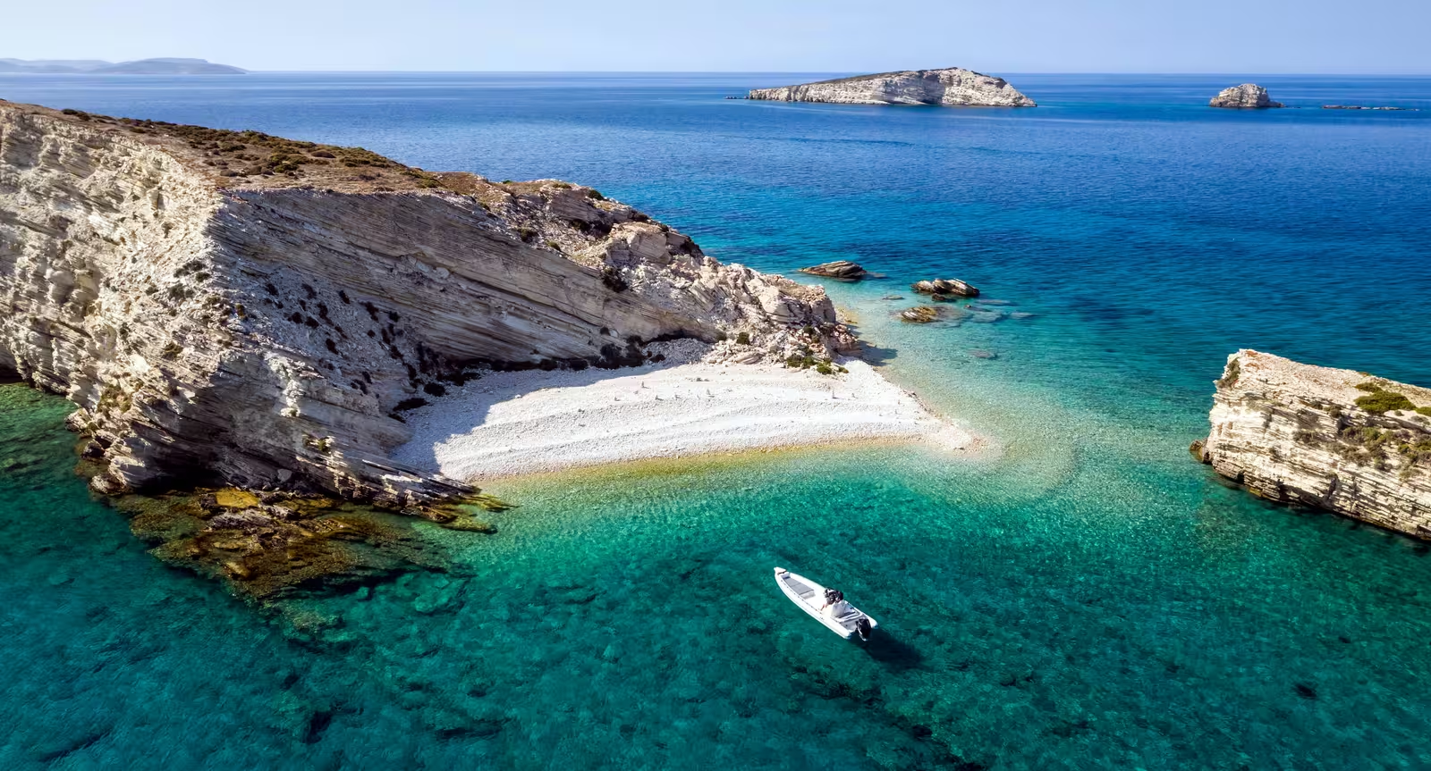
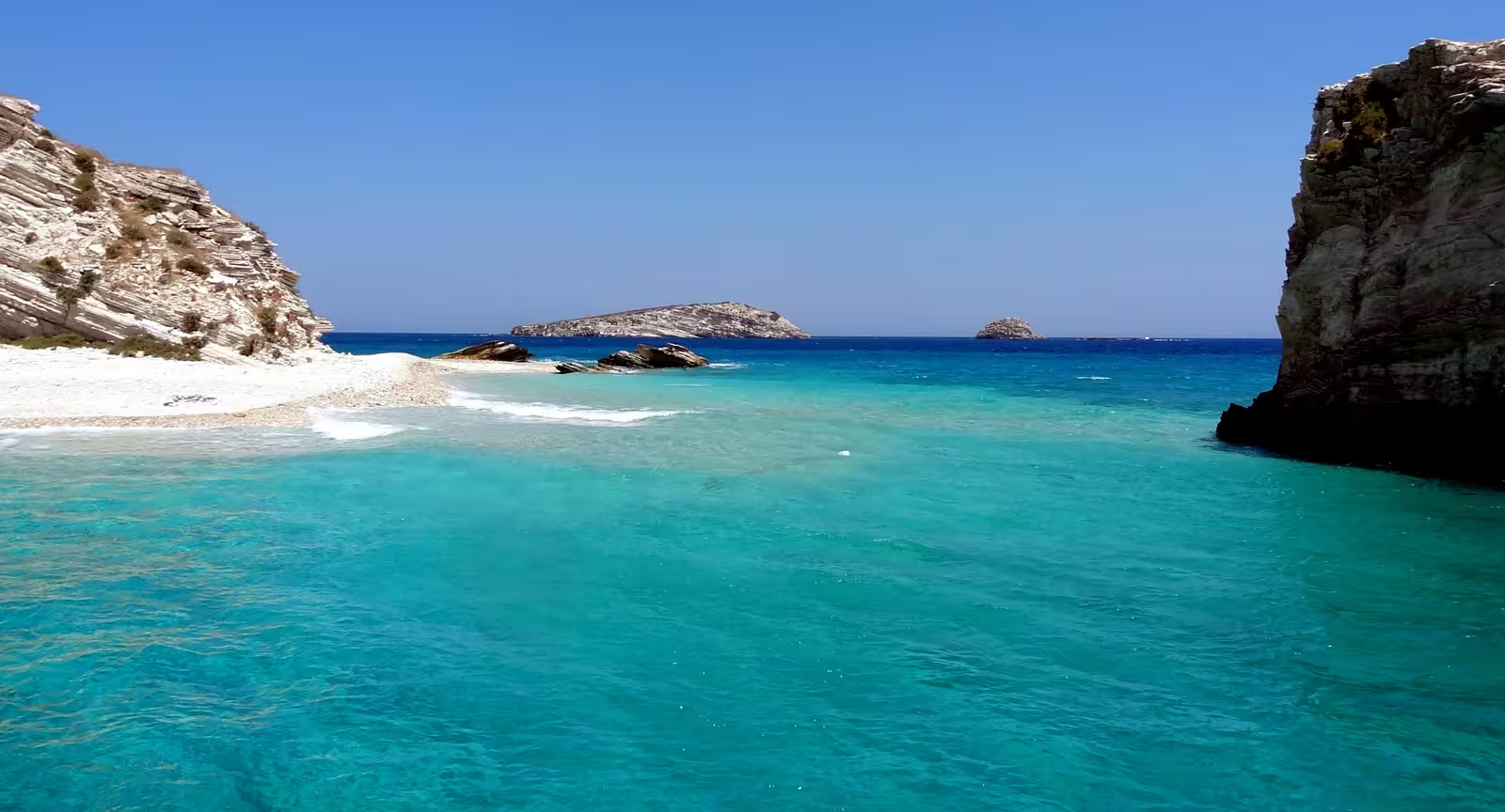
Tiganakia
Tiganákia - Τηγανάκια – which means “pans” in Greek –
is a superb sandy beach without rows of parasols and sun beds; kids heaven.
Although the anchorage is Meltemi-proof (NW winds) with excellent holding, relocating to Porto Augusta or Makronisi is advised in stormy conditions.
The secluded basin has room for 6 – 8 yachts, or far more when lines are taken to the shore; the useful large sandy area is readily sighted; you can also anchor outside the basin, i.e. directly east in 7 – 12 m,
Lat Long; a heavy swell will work its way around the east cape of Arki in strong northerlies and easterlies.
View this helpful drone video [YouTube], and
mind the submarine cable.
Tiganakia's appeal is well-deserved and well-known: eager beach tourists are shipped in on fleets of caiques and day tripper boats.
Furthermore, dinghies and tenders from the other anchorages all converge to this spot; these yachtspersons perhaps picked a more felicitous spot to lower their anchors…
Near the shoreline is an enclosed resort with blocky holiday homes that are subtly embedded in the landscape, were it not for the occasional rumble of a generator.
The spectacular beauty of this shoreline is rare, but reminds me of the equally translucent waters that are found on e.g. Astypalaia (Ag Fokas), Kyra Panagia (Ag Petros) or Polyaigos.
Lastly, Tiganakia is noted for the excavated prehistoric ceramics (Neolithic period).
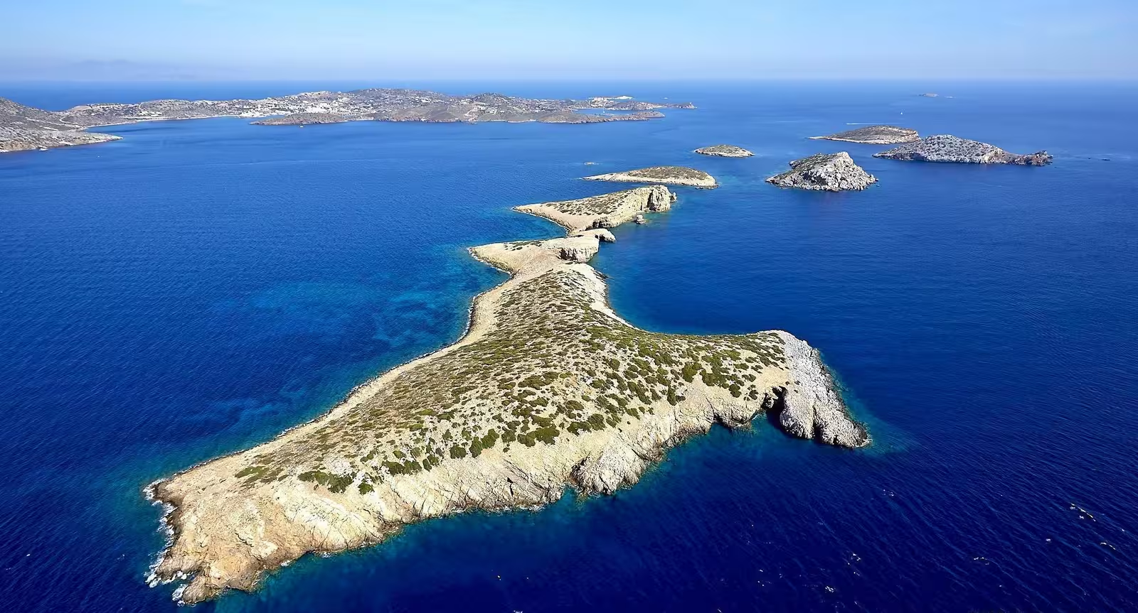
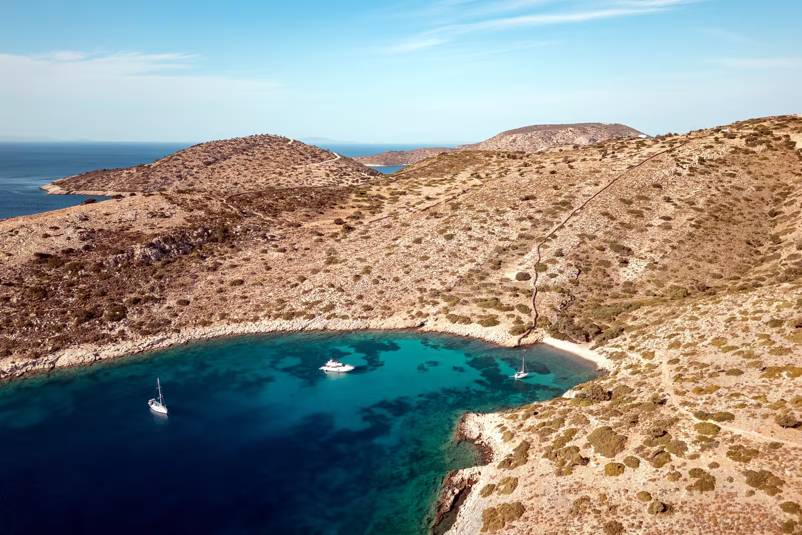
Makronisi
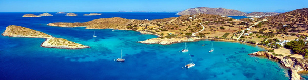
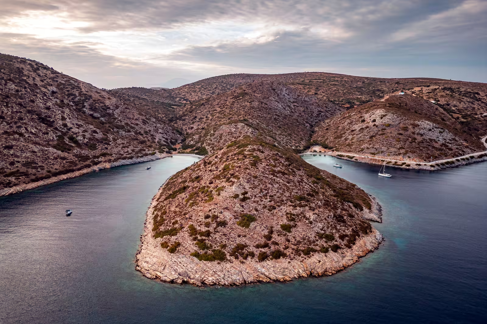
Makronísi - Μακρονήσι is a formidable stunning anchorage with amazing aquamarine waters and magnificent vistas over the tiny archipelago. It is a short dinghy ride to the disembarkation pier of the beach of Tiganakia from where you can explore Arki island.
There is excellent holding in dense sand, anchor in 4 – 8 m Lat Long; completely Meltemi proof; even in a gale force there will only be a little swell; plenty opportunities to take a line ashore.
The islets of Tsouka and Tsoukaki guard the south(west) of the anchorage – the name Tsoukaki is a diminutive form, meaning “little Tsouka”; compare for instance η γάτα – το γατάκι: gata – gataki, cat – kitten.
The northern side of the passage between Makronisi and Tsouka has over 4 m depths; on the south side there are some dangerous shoals with 1.4 m; since these channels are not sufficiently charted, make sure to reconnoitre first.
Especially in August the whole area can get full to the gunwales when also superyachts and day tripper boats vie for the best spots. The speed boats and yacht tenders will shatter the serenity with noise, wakes and dangerous driving; the day tripper nuisance is mainly between 11:00 and 17:00.
Avaptisto
Aváptisto - Αβάπτιστο – meaning “unbaptised”, with the implied meaning of “unbeliever” or “infidel” – offers two anchorages on either side close to the shoals that chain this minute isle to Arki and Makronisi.
South-east of Avaptisto, i.e. south of the shoal that joins the islet to Makronisi.
Anchor in 5 – 9 m, solid holding in sand, Lat Long, though some yachts will opt for 10+ m waters when crowded.
The setting with its turquoise waters is entrancing in every aspect, except that in July and August speed boats race right through the anchorage zone.
West of Avaptisto, i.e. south of the shoal that joins the islet to Arki.
Again, the water and vistas are stunning, but the locals (on fishing boats or caiques) as well as yacht tenders use this shallow channel, so there can be quite a bit of N – S traffic.
Anchoring is straightforward with solid holding in sand, aim for Lat Long; hardly any swell, northerlies can funnel between the islands.
The anchorage is rather too narrow to allow proper swing anchoring with a decent scope; once you dive/snorkel you might well discover a few nasty rocks within your swing circle; be prepared to set the second anchor; the area is not well charted.
It is handy to take a line to the islet, with the stern pointing NE.
Mind that strong Meltemi storms will have a western component meaning that with stern lines tied to Avaptisto these winds will then blow abeam. In these conditions the other anchorages: Makronisi and Avaptisto SE are superior.
Glipapas (Porto Grosso)
Glípapas - Γλίπαπας aka Porto Grosso or Glipapa bay
is at best a lunch-stop anchorage since the thick weed patches make anchoring hazardous. Moreover, even on the sand there might be flat rocks underneath preventing the anchor to dig in; this bay is deeper than its narrower twin (Steno) at 10 – 14 m; open to southerlies; there is the option to take a line to the rocks about halfway at the promontory; cerulean water; some swell can enter, and at the head of the bay is a nice beach.
Note that the Greek Waters Pilot incorrectly combines both Glipapas and Steno into a single Port Stretto; see Eagleray.
Patmos can be seen behind the islets of Strongyli, Marathi and Grillousa left, and Ikaria on the horizon on the right.

Steno (Porto Stretto)
Stenó - Στενό aka Porto Stretto is evidently a very narrow inlet, in fact the Greek word Steno is a direct translation of the Italian stretto meaning “narrow”, “tight” or “strait” – see more Greek chart terms. The local fishermen simply use Harbour highlighting the excellent shelter and Meltemi protection they find here.
Fortunately, there are 4 mooring buoys (flimsy white plastic) with solid ropes connected to a heavy chain that runs from north to south on the shallow seabed.
However, the innermost one has just 1.5 m depth within its swing radius, the second 2 m, when using a 45 ft yacht.
The two outermost ones have a minimum of 2.8 m depths within the swing radii.
So, only the two southern ones are acceptable for monohulls, whereas the inner two are perhaps an option for catamarans.
To reduce the swing radius, use a bridle (or two) and connect to the mid-cleat instead of the bow.
If you use a buoy you should dine at the taverna, which is a little green oasis. Taverna Apólafsi is family-run serving authentic Greek dishes; απόλαυση is Greek for “enjoyment” or “delight”; there is no reservation possible.
Although swing anchoring is not possible, there are options for Turkish mooring (anchoring with shore lines) on the NW shore, south of the mooring buoys: drop your anchor near the opposite shore 4 – 8 m on a seabed mixture of sand, rock and weed.
Marathos
The beautiful islet of Márathos - Μάραθος aka Maráthi - Μαράθι has a sandy and quite secluded bay on its east coast, whereas the rest of the coastline is mostly rocky and partly steep.
The landscape is determined by the typical representatives of the Phrygana, the Greek version of Garrigue, however, the eponymous fennel (μάραθο, Maratho) is rarely found today due to excessive animal husbandry.
The population consists of just two families, depending on hospitality and goat herding, which rely on water from a Rhodian tanker and electricity from solar panels and a submarine cable from Arki. The only buildings are a few 20th c. ruins, some tourist accomodations, the Ag Nikolaos Church and two restaurants (open in the summer months): “Taverna Stavragos“ in the middle is rather charming but perhaps a bit pedestrian, whereas “Restaurant Pantelis” to the north is more expensive; mixed feelings. The crowd-pleasing “Pirate bar” closed in 2022,
The mooring buoys are both a blessing and a curse.
The exact number varies each year, but you will find 6 – 10 well maintained mooring buoys, of which ~6 red ones belong to Pantelis restaurant.
Note that these are placed very close together, resulting in a maximum LOA of 45 feet to prevent drifting into each other when the wind dies.
Furthermore you can only assume these buoys to be present from end May till early October.
There is no obligation to dine at either of the 2 restaurants, there is no booking system, and there is no assistence with picking up a buoy.
The curse obviously is that the permanent moorings, as well as the discarded old concrete blocks plus tackle utterly foul the anchorage.
and outside the 4 summer months or in summer but with all buoys taken, there is hardly any suitable seabed left to anchor securely.
One work-around is anchoring and taking a line to the shore in the north.
Be sure to climb the low hill – the highest peak of Marathi is just 50 m – and enjoy the glorious panorama over this tiny archipelago, a view that is especially rewarding at eventide.
The bay offers excellent snorkeling conditions: crystal clear waters with plenty of sea life. Up in the air look out for
Eleonora's falcon, which will nest here and can be seen hunting, as well as the
Audouin's gull.
Note, in the foreground right, the reef extending from Spalathronisi.
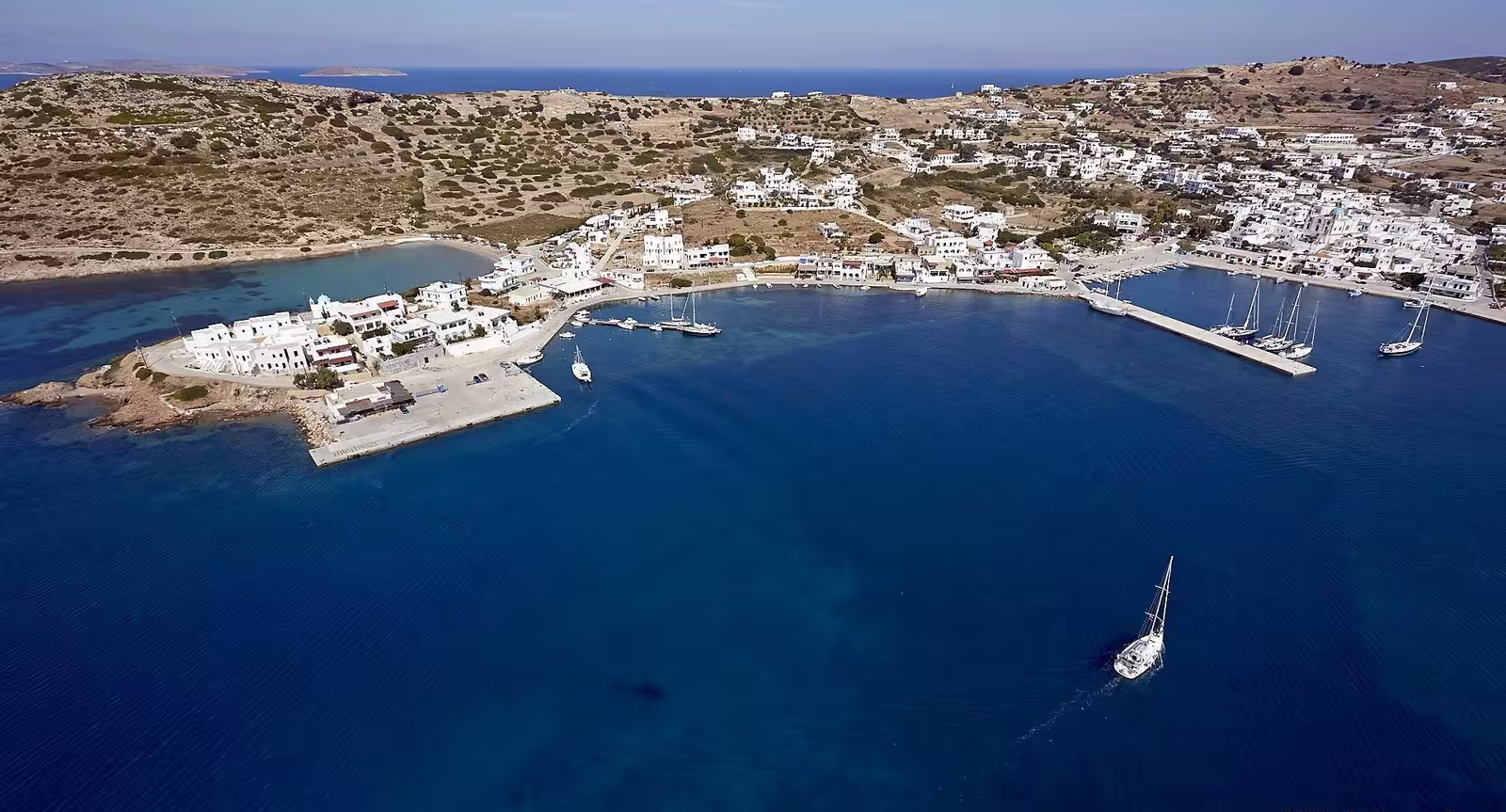
Lipsi island
Much of the land on Lipsi or Leipsi - Λειψοί was owned by the Monastery of St John the Theologian on Patmos.
Today, you can see small, white, blue domed churches dotted all over the island's rolling hills, which gently slope down to meet the sparkling Aegean Sea. Lipsi's coastline consists of a number of small bays, sheltered coves and beaches with shallow, crystal clear waters.
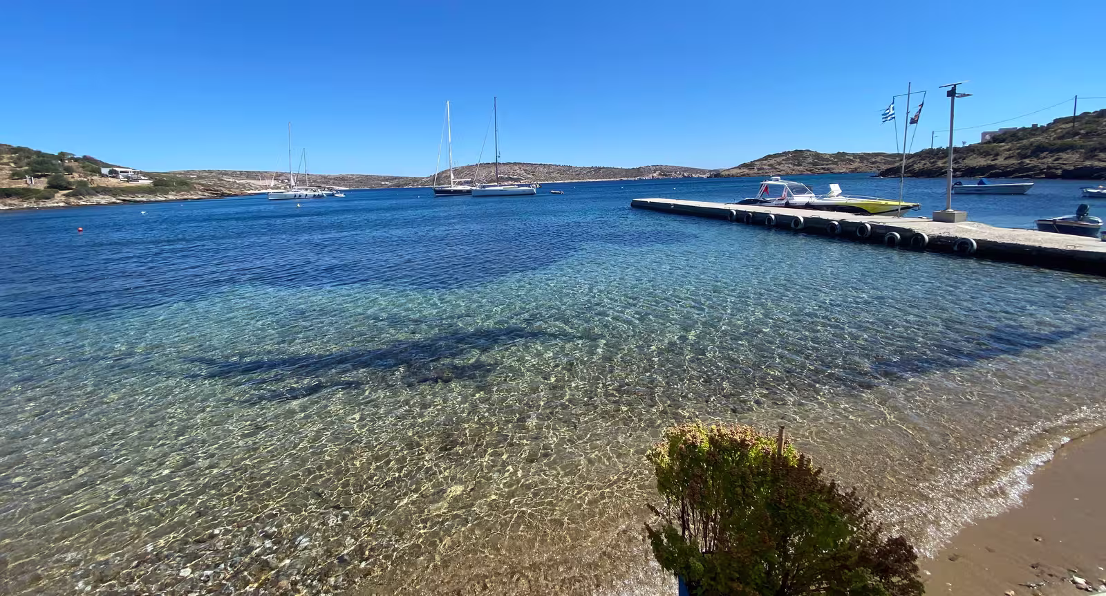
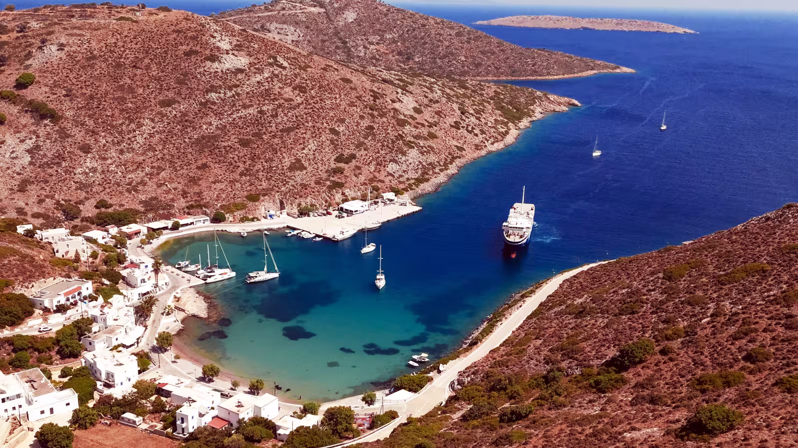
Lipsi port
Lipsí - Λειψοί or Leipsí is an off-the-beaten-track and must-see port even without major (archaeological) sights and is set amid a greenish landscape due to several natural springs.
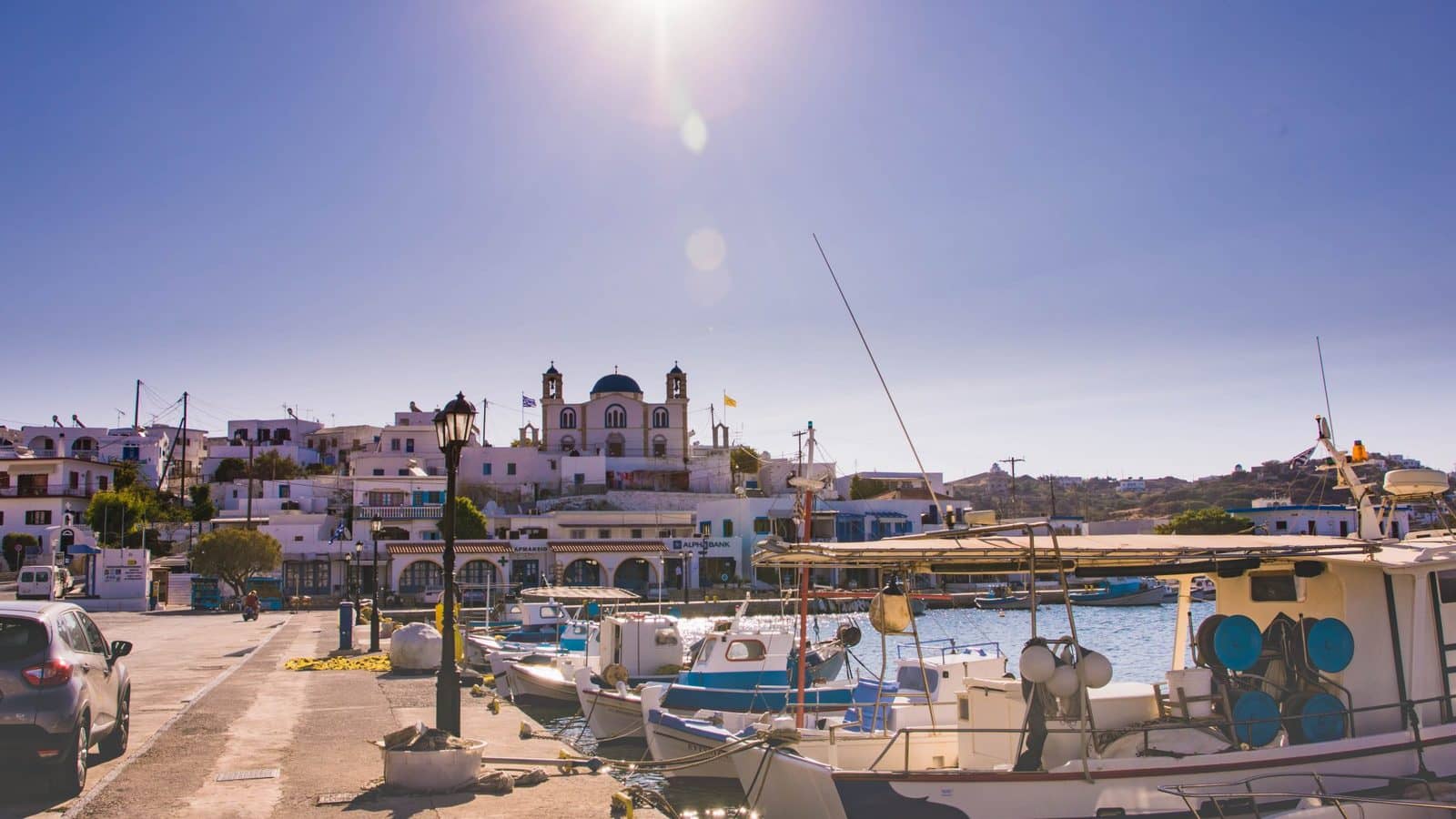
The town – like the whole island – is well organised and has retained much of its authenticity and ambience by banning huge cruise ships, mega-hotels / resorts, as well as prohibiting the construction of buildings over two floors high. Moreover, EU subsidised roads mean that scooters and cars, instead of donkeys (half a century ago), are in soaring numbers the mode of transport, connecting the various bays and beaches of the island.
The yacht pier was finished only in 2001, so previously there was no basin and only the pontoon
near the ferry dock – often in rolling conditions – was available for smaller visiting yachts.
Having outlived its purpose this pontoon was removed in 2020, but it is still shown on most electronic charts.
Traditionally – instead of Lientou – ormos Kouselio, was used in southerlies. Nowadays this large shallow bay just south of the port is filled with permanent moorings. Moreover, the east end of the entrance is reserved for “work in progress”.
You won't find garbage bins on the island, only recycle bins. But leniently, unsorted-garbage bags from the yachts and catamarans are collected every morning and late afternoon at the entrance of the pier. Another environmental measure is the “drinking water refill station” behind the Church in order to reduce plastic water bottles.
Water and electricity pillars can be found along the quay and on both sides of the yacht pier; check water quality before filling your tanks; diesel fuel is available on the south side of the port or can be delivered by truck.
“Casa di Vino” sells cards for water / electricity. Also the harbour master, Manolis, will have cards: ask for a full one. Learn about the name “Manolis”…
Going alongside is possible outside the main holiday season, but in the summer months you will be required to go stern-to, often in a crosswind since the prevailing wind is NW;
no lazy-lines are present which may result in crossed anchors; the Meltemi also blows NW.
The inside (east) is preferential with more shelter and less rolling, but even here you should
look up and verify that your spreaders cannot touch the neighbour´s rigging; the outside can suffer from truly rolling conditions proving that the yacht pier is an excellent breakwater;
everywhere in Lipsi port the seabed is a bit muddy but still offers decent holding.
The port has public toilets, no showers and unfortunately, the “Easy Wash Laundry” has permanently closed its doors,; the quayside was freshly painted and spruced up in 2025.
Tuesdays and Wednesdays are the busiest with charter yachts coming from Kos yacht charters base (and a few from Samos).
Make sure to listen to the instructions of harbour master Manolis when he assigns you a berth. He will collect a "tie down fee” of €5 if he assist you with your mooring lines; this fee was €2 before the pandemic: inflation.
Culinary: you should try “Manolis Tastes” at the Church – no relation to the white bearded harbour master Manolis,
“Gyros Lipsi”,
“Ouzeri Asprakis" at the start of the pier as well as “Casa di Vino” which caters to yachts and serves cocktails .
The town has two bakeries: for authenticity aim for “Kristallis”, while “Kairis” bakery offers seating and coffee.
“Calypso Minimarket” is located at the start of the pier selling lots of fresh fruit & vegetables, local wines, honey, etc.
Watching over the port is the Church of St John the Theologian with its blue cupola which is spectacularly illuminated at night. The current basilica was constructed in 1931 from hewed stone and financed by Lipsian immigrants in the USA. Inside you will find precious reliquaries containing the remains of monks reduced to martyrdom, slain by the Turks during the dark years of the Ottoman rule. Five of those monks have recently been beatified by decree of the Greek Orthodox Partriarch.
Visit the Lipsi Museum which collection is an interesting and mixed wunderkammer of ecclesiastical, folkloric and archaeological artifacts.
Lientou • Kampos • Christos
These three anchor options – adjacent to Lipsi port, listed from east to west – offer reliable holding in sand, but mind that winds can easily turn here and the area is subject to katabatic gusts in the night; even more, the wind can funnel between the hills; lots of swell, rolling conditions even without wind; beautiful water; more exposed perhaps that it seems on the chart, but only untenable in SW winds; the Meltemi blows NW.
Lientoú - Λιεντού is the overflow anchorage nearest to Lipsi port, providing room for about ten yachts.
Note that the bay is very shallow with a nearly horizontal seabed ending in a delightful beach and popular swimming spot; make sure that your entire swinging circle has sufficient depths.
Anchor in 4 – 8 m, usually on the east side, Lat Long, which is unfortunately outside the actual bay.

On the right (west) the Chalavra islets with Makronisi in a 20 knots westerly wind, early May. Hi-res image
Kámpos or Kambos - Κάμπος is our preferred anchorage near the port (certainly in northerlies) where you might be joined by superyachts since this is a premium spot for them: proximity to Lipsi town, and privacy for the guests.
On land there are just a few hotels. The road is now paved and ressembles a quiet boulevard – in 2007 this was a dirt track.
Slightly uphill you will find the picture-perfect Ag Georgios Church.
There is often less rolling than in Lientou, but no guarantees, Lat Long.
Christós - Χριστός brings the same protection as Kampos and is the top choice in NW winds; you can anchor quite close, Lat Long, to the Church of Christ.
Moschato
The remote bay of Moscháto - Μοσχάτου consists of 4 deep and narrow inlets, which combined protect against all but the common northwesterlies. In the Greek Waters Pilot this bay is addressed under “Ormos Vroulia”.
The first (i.e. westernmost) inlet, together with the second inlet, are the loveliest, but also the most exposed anchorages. You should take lines to both shores and anchor with the bow facing in or out; only feasible when the wind has no strong north component.
Vroulia bay (the third inlet, counting from the west) will become a dolphin sanctuary and is off limits, including the new square mole, since the “Aegean Marine Life Sanctuary” operates from here.

The fourth (i.e. easternmost) inlet holds a small fishing port, which has depths of less than 2 m. On the approach the seabed rises steeply and suddenly.
Avoid the myriad discarded mooring buoys, ropes and trash from the former fish farm by
taking a line to the NW shore just outside the port, Lat Long.
In all the inlets you will find more weed than sand with nonetheless good holding. Each of the three accessible inlets fits 2 – 3 yachts with a bit or organising. Moschato is not practical for staying the night in strong northerlies. Except for the main sailing season you will be alone here; great for stargazing. With small children the second inlet is top: best beach and some nice rocky features (e.g. pools) to explore on the east shore. There is a usable footpath (donkey trail) connecting the heads of the first three inlets. The bay acts a funnel and is a lee shore in the prevailing NW winds collecting visibly more plastic and discarded fishing gear than any other area of Lipsi.
Platis Gialos
Platís Gialós - Πλατύς Γιαλός is a rather pretty beach and anchorage with good protection against the prevailing NW winds.
Most of the inner bay is less than 3 m deep, but you can swing at anchor just “inside”, Lat Long; the seabed is sandy and some larger pebbles; there is good holding and no swell.
The outer bay is commodious and fits upto a dozen yachts, mostly swinging, but you will likely end up mediterranean mooring to the rocks, where you can also snorkel and discover sea creatures such as the yellow tube sponge Aplysina aerophoba. Ashore is the Restaurant "Platis Gialos".
You can expect lots of tourists to gather at the beach for sun bathing and swimming – as do a dozen of local ducks – while gulets and caiques will use the rectangular slab of concrete to bring in more beach enthousiasts.
The road on the south side is used by loud motor cycles at night, attaching stern lines to the north side is preferential.
“Platis Gialos” or “Platis Yialos” means wide shore in Greek, referring to its spacious beach, not the length of the beach: the name correctly suggests a shallow anchorage, see the A-Z index for other places named “Platys Gialos”.

Aspronisi
Aspronísi - Ασπρονήσι is a ravishing venue with one of the most scenic beaches of the region and a fascinating geology of inclined strata and white cliffs to match. Birds such as the Eleonora falcon use these cliffs to nest in small colonies.
The only anchorage is located between Makrý (long) - Μακρύ Aspronísi aka “white beach” and Makró (large) - Μακρό Aspronisi, Lat Long.
Especially in August the beach – with its distinctive white flat pebbles – is swarmed.
Fortunately, after 17:00 all the day tripper boats and caïques will have left.
The seabed is sand, small & larger pebbles, rocks and boulders, so it is sensible to use a tripline;
anchor in 4 – 11 m.
The northernmost islet is called Megalo (big) - Μεγάλο Aspronisi and doesn't have a adequate place to anchor.
The collective name for this small group of rocks and islets is Aspronisia - Ασπρονήσια,
which translates as white islands. While lefko - λευκό is old greek for “white”, this has been replaced by aspro - άσπρο when describing colours, however when ordering wine you still use lefko.

Makro islet can be seen on the right, with further on the Megalo islets.
Kouloura (Chochlakoura)
The bay of Kouloúra (Chochlakoúra / Hohlakoura) - Κουλούρα (Χοχλακούρα), Lat Long, is arguably the best anchorage on Lipsi island offering snorkeling in crystal clear waters with rock formations, caves and arches, plus plenty of sealife. Moreover, due to the near absense of light pollution at night you can enjoy stargazing.

There is solid holding in sand; anchor anywhere in this wide bay in 5 – 11 m; the seabed is almost pristine and without rubbish; the north and NE parts are flat, while in the west the bottom is steeper.
Although it can still be windy, Kouloura is very safe in a Meltemi, which regularly turns from NW to N in this part of the island; no swell in prevailing winds.
The disembarkation pier is used by a tiny fishing boat, therefore hoist your tender on the pebble beach; you can desposit your garbage at a waste recycle and collection base.
The shoreline features no taverna and no organised beach.
Interestingly, this means that the bay is less crowded with sailing boats, despite being more spacious than e.g. Lyra and Katsadia, as well as having the best storm protection in northerlies and westerlies.
Visit the idyllic oasis of “Dimitris Farm and Vinyard”, 400 m inland, for organic vegetables, fruit, olive oil, wine, cheese as well as a small petting zoo: chickens, donkeys, goats, sheep, etc.
Although it is possible to pass between the various islets / rocks / reefs (collectively called the Kouloura isles, i.e. Nes Kouloura) that extend SE of the anchorage, it is only prudent to do so in good conditions.
and two sailing yachts in Papandria/Lira behind Lyra island and shoal,
looking west, clearly visible are the Chalavra (Makronisi) islets, plus on the horizon Patmos. Hi-res image
Katsadia
The bay of Katsadiá - Κατσαδιά has two anchorages:
- East Katsadia
is just a tiny cove with room for 2 or 3 yachts when swinging at anchor, Lat Long; plenty of rocks to take a line to on the west shore.
Verify that the anchor has truly penetrated, since there are some flat rocks (or very hard sandy layers) that are merely dusted with sand. Moreover, there is quite a bit of rubble (lines and some netting) on the the seabed that can foul the anchor; decent holding in sand; winds get funneled into the bay due to the cliffs on the east side.
At the head of this cove is the short beach of Limni (marked by a dozen luxury sun beds and parasols) with an enjoyable cocktail bar, that turns into a discotheque at night. Yet, this is still preferable to the incredible noisy nuisance that is the notorious Dilaila restaurant in Katsadia west.
West of the beach and bar is a handy disembarkation pier. - West Katsadia
is wider and there will be up to 20 vessels in the main season, while there is merely room for 5 swinging at anchor (at least with enough scope).
“Dilaila Restaurant”, located on the east side of Kastadia beach, is closed roughly 1 October - 1 June. While during the day this is a nice (vegetarian) taverna, in the evening the place turns into a night club disgorging agonisingly loud music, sometimes till early in the morning. Reportedly, this happens a couple of times per week: these private parties for the privileged ruin it for everyone else, proving that money can't buy style.
The mooring buoys in front of the beach have gone since 2022; the ropes and chains were not sturdy enough anyway. The bottom is sand and muddy; good holding; anchor anywhere in 4 – 9 m, Lat Long; seabed more poluted than in Lyra bay, debris visible, plus you should be cautious of the discarded mooring blocks and ropes that foul the anchorage; near the restaurant is a disembarkation pier.
looking south with Lyra islet on the right and Leros island on the horizon. Hi-res image
Lyra • Papandria
The anchorage is named after the beach Papantria / Papandriá - Παπαντριά / Παπανδριά or the islet of
Lyra / Lira / Lera - Λύρα and is set in georgeous waters.
You will find full protection from the Meltemi and a decent area with sandy bottom that provides solid holding, all in shallow crystal clear waters; anchor anywhere in 4 – 8 m, Lat Long, where you see either sand or a thin layer of weed.
Repeat the anchoring manoeuvre if you notice muddy plumes emerging from the seabed.
Be prepared for sudden gusts during the (otherwise calm) night; the prevailing wind is NW; there is hardly any swell, except in easterlies.
You can expect 15+ vessels in August and with more
than 6 sailing boats it is custom here to take lines ashore to Lyra or Lipsi, there are even good rocks at the beach. Alternatively, there is a pleasing small cove, Lat Long, in the west.

Confoundingly, the renowned Greek Waters Pilot considers this bay to be “Kouloura”, yet Kouloura is one of the islets that guards the actual Kouloura (Chochlakoura) beach / bay on the SE of Lipsi. Not to be confused with Kouloura in Corfu.
If you move to Katsadia, on the NE side of Lyra: in the middle of the passage between Lyra islet and Lipsi is a 4 m deep obstruction, aside from that it is navigable for all vessels.
In the summertime in the morning, reportedly, a food truck sells fresh vegetables.
Chalavra (Makronisi)
The small low lying (43 m) island group – located SW of Lipsi island and called Nes Chálavra - Νες Χάλαβρα or Nisiá Stifis - Νησιά Στίφης – offers a few anchorages, notably north and south of the famous lagoon on Makronisi islet.
There is no official chart for this area, consult the Eagleray Sea Guide before attempting to approach or pass in between these islets. Of the electronic charts C‑Map has the best resolution and shows the passages.
The isle of Makronísi (Lipsi) - Μακρονήσι offers a 2 m deep circular lagoon and a cave to swim through, which makes this a seriously popular venue – despite this, you will be (mostly) alone before 10:00 and after 16:30.
- In southerlies there is a sandy anchorage 3 – 9 m on the north side, at the isthmus, where you should avoid some flat rocks resembling sand,
Lat Long.
Low limestone cliffs and interesting rock formations; the south side of the lagoon is connected by an underwater cave that leads to the open sea; bring water shoes.
In the evening when all the beach tourists are gone you will only hear the local goats.
- In northerlies you can anchor at the south side in deeper water with a steep seabed, hardly suitable for staying overnight. There is a workable sandy spot at a depth of 14 m, Lat Long,
but because of the many rocks and boulders nearby you should consider using a trip line. Moreover, one person should remain on deck if the rest explores the lagoon and grotto.

Agathonisi island
The northernmost island of the Dodecanese complex is Agathonisi - Αγαθονήσι, Eşek Adası in Turkish, known in Roman times as the island of Tragia, where the young Ceasar was captured by pirates in 76 BCE.
During the prehistoric period it was inhabited by Carians. The Ionians of Miletus followed and later the Dorians. With a gold bullion offered by Alexios I Komnenos, Agathonisi is subsequently donated to the Monastery of Patmos. Until the 14th century CE it was a hiding place for pirates, while in 1522 it came under the rule of the Turks.
The newest settlements on Agathonisi were made by residents from Patmos and Fournoi in the beginning of the 19th century. In 1912, the Italians succeeded the Turks and on March 7, after the integration of the Dodecanese into Greece in 1948, it was administratively subordinated to the Municipality of Patmos. In 1954 it became an autonomous Community.
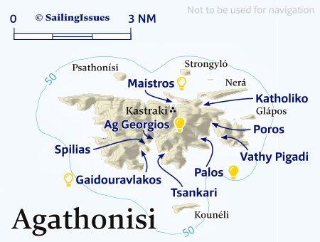
Ports / anchorages are clickable .
signifies a highly recommended venue, and a truly must-see venue; see other icons.
Agathonisi has neither sandy beaches nor well-known ancient monuments (Kastraki is the exception) to attract visitors and is therefore reasonably untouched by the tourist trade.
Aside from the port of Agios Georgios, there are the villages of Megalo Chorio - Μεγάλο-Χωριό and the almost abandoned Mikro Chorio - Μικρό-Χωριό, the permanent population is just over 100 inhabitants.
The festivities of Saint Panteleimon (26 July) and Assumption of the Virgin Mary (15 August) are a treat. In both, there is a long preparation of several days, with food and sweets offered by the housewives, breads baked in wood-fired ovens and of course music and dancing.
The island's shape resembles a donkey, which is why some of its older names were Gaidaros or Gaidouronisi.
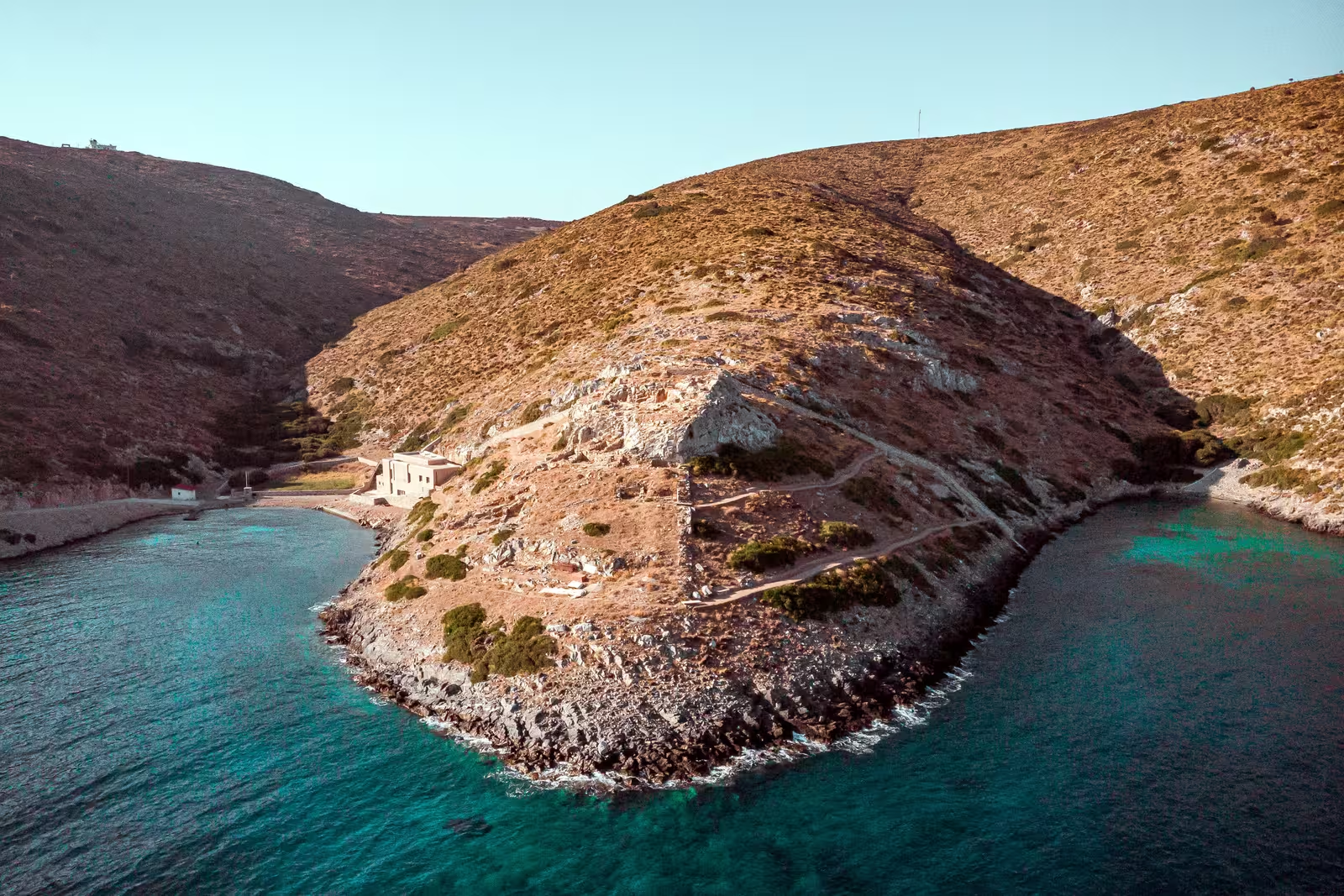
Maistros
Erroneously, the bay of Maistrós or Maïstros - Μαϊστρός is sometimes called Katholiko which is the tiny fishing port and abandoned village further east.
A port from the Hellenistic period (late 4th – early 3rd c. BCE) has been found in Maistros, surrounded by strong fortification walls (1.80 – 2.00 m thick), known as
Kastraki, literally meaning “small castle”.
The ancient port of Kastraki was manned militarily from Miletus. It was a naval base of Miletus, as Agathonisi, Leros, Lipsi and Patmos were the so-called Milesian islands. That is, the islands that Miletus used as a passage to the Aegean.
Maistros bay doesn't offer much room to swing, as you will have to anchor close to the shore, preferably in the east, Lat Long, in 5 – 7 m; the seabed is thick mud; dangerous in NW – N, also due to swell entering.
The nearby desalination unit is perhaps an eyesore, but its construction is the reason why the excavations could start and the archaeological site was discovered in the first place.
The small fish farm in the bight across from the archaeological site was removed in 2015.
In any southerly or easterly wind Maistros is a natural harbour with a historical bonus and is worthwhile as a lunch-stop.


Katholiko
The fishing harbour and bay of Katholikó - Καθολικό is far from picturesque, even though the
fishfarms – still shown on C-Map, Garmin, etc. – were remove in 2025.
Annually about 500 metric ton of fish was “produced”, mainly for the USA. The few ramshackle buildings in these slummy surroundings now tell the story of the lucrative and equally ugly times when more than 25 islanders depended on intensive factory farming of fish. The village of Kathólikon is therefore almost abandoned; the name
katholiko suggest a religious origin.
Vathy Pigadi
Vathý Pigádi - Βαθύ Πηγάδι is Greek for “deep well”, referring to a waterwell or spring, and is the tiny bight opposite Palos – a lunch-stop anchorage in light weather.
Although there is lots of sand to drop the anchor on, it offers hardly any shelter except in rare easterly winds, Lat Long.
To the east you can visit the little Church of Saint Nicholas (Agios Nikolaos) and the vaulted stone ruins known as “the Vaults” aka “Tholi”. These
11th c. Byzantine buildings with air ducts on their roofs, were used as storerooms, probably for food.
A decade ago there was a small rectangular fish farm in this bight. The seabed seems however without the debris that is typically left behind, perhaps since the main round farms were placed in the entrance of Poros bay – all were dismantled in 2016.
Poros
The spindly bay of Póros - Πόρος can host only a single
yacht and is too tight to comfortably swing at anchor.
Moreover, the seabed is mostly rocks and weed, alltogether troublesome although it could still be a realistic lunch-stop anchorage for swimming and snorkeling; anchor in 5 – 8 m,
Lat Long.
Not to be confused with Poros port and Poros island in the Saronic Gulf.
Palos
The well protected and dazzling bay of Pálos - Πάλος is set in exquisite clear waters, comparable to Astypalaia or Alonissos and can accommodates up to 6 boats.
With more room to swing at anchor, the large sandy area, and with good holding, this is justifiably the best anchorage on the island, also since it is very well sheltered against the northerlies and Meltemi storms; anchor anywhere in 6 – 15 m. The clear preference is to take a line to either the north of south side of the beach, Lat Long, in 7 or 8 m; no swell in the prevailing winds.
In 2022 the path, that brings you to the village in about 20 min., was freshly paved, but this has brought only a few extra sunseekers. The path starts at the north side of the beach and will first lead you away from the village, then at the parking spaces you can turn left and follow the main road.
Although the beach is stones / pebbles there lots to see for children.
In the morning you can greet the fishermen that have arrived in the night in their traditional caïques (kaikia). Otherwise there are only goats.
Tsankari
The bay of Tsankári - Τσαγκάρη has more
rocks and seaweed than the adjacent bays, furthermore, the seabed drops quickly and most of the bay is too deep to anchor. Since it is so difficult to anchor reliably, it is unwise to leave the yacht unattended.
It does help to place the anchor on a sandy patch (looks weedy) at a depth of 8 – 10 m in the middle, Lat Long, and bring two lines to the shore on the N or NW side.
Tsankari is the Greek word for “schoemaker”.
Ag Georgiou
The lovable ferry and fishing port of Agíou Georgíou - Αγίου Γεωργίου aka Ágios Geórgios - Άγιος-Γεώργιος – actually the only meaningful harbour on Agathonisi – is shipshape, authentic and not touristic. Note that Agiou Georgíou is the genitive form of Agios Georgios, see agios–agiou.
The little bay and port offers full protection against the Meltemi, which typically blows NW here, gusts (katabatic) are W or NW; prolonged SE winds will cause a nasty swell, and strong S and SE winds will make the bay untenable, see weather forecasts onboard.
Most amenities are locally available, such as diesel (jerry can), toilets, electricity, water and showers; you can swim right off the boat in seemingly good water quality (no sewage), an almost untarnished seabed and with fish abound.
There are three mooring options in Ag Georgios, all free of charge:
- The quay on the north side is the premium spot, including a few berths beyond the west corner, with room for 10 yachts in total. The stern line should be especially long to avoid damage to the rudder, and depths are also at the quay too shallow for most keelboats to use a passerelle. West of the quay you will find a couple of big yellowy bollards encased in the rocky shore; make sure to stay 4 to 6 m out, and use the dinghy as a shuttle. Preferably attach two hawsers, as the prevailing winds are on these stern lines. Caution: the small (catamaran) ferry produces more waves than the larger ferry, yet the passing of either ferry can push you towards the rocks or quay.
- The anchorage in the NW corner is awfully narrow since you need to leave enough room for the ferry to manoeuvre, which will dock at right angles to the ferry quay. There is just room for 2 yachts to swing at anchor, a third might fit after the ferry has left.
Anchor north of the ferry quay in 5 – 7 m on
mostly sand; excellent holding, try to bring a line ashore.
The 2 mooring buoys that were briefly placed for the 2023 season are already history, leaving behind the concrete blocks and some chain visibly on the seafloor. - The ferry quay fits 4 yachts alongside but rafting up is possible. The northernmost section is often reserved for the small coastguard vessel (sometimes 2 vessels). You can be asked to leave (temporarily) when a ferry is due, which takes only 15 minutes to arrive and leave. Once the last ferry has left you are allowed to spend the night here. Occasionally a freighter visits and will dock alongside.
Water and electricity is available on the quays – depending on position a long hose / cable necessary – and you need to buy a €10 card at Voula's Gift Shop. There is a minimarket in the NE corner of the port and a further one in Megalo Chorio near the Church: fresh bread, etc. from Samos is brought in with the ferry.
Two sailing boats are moored alongside the ferry quay behind the coastguard.


Spilias
The bay of Spilia or Spiliás - Σπηλιάς is both popular with yachtspersons and beachgoers, though outside the main summer months you might be alone.
Since spilia - σπηλιά is Greek for “cave” or “grotto”, the tourists rightly call this venue
“Cave beach” although the eponymous cavity on the NW side is hardly impressive…
There is reasonably good holding in sand once through the weeds, the sandy area is large, Lat Long; 2 – 3 boats max. at swing; avoid a few rocky areas (slabs) hidden under an insufficient layer of sand; in windier conditions it is prudent to moor stern-to the rocks on the north side.
From the beach you can walk the short distance to the village of Agios Georgios, follow the paved road.

Gaidouravlakos
The beach Gaidouravlákos or Gaïdouravlakos - Γαϊδουραύλακος is harder for sunseekers to reach and is a quieter anchorage than Spilias.
There is just room for a single yacht to swing at anchor (short chain),
Lat Long, in ±8 m of water.
So, you will likely want to take a line ashore (Greek style aka Turkish style), and it is easy to take lines to the rocks here.
The bay is Meltemi-proof, but winds will funnel between the hills with gusts alternating NW and N; reportedly better holding than Spilias, again sand and a bit of weed and small pebbles;
indulge in stargazing at night and the truly pellucid waters during the day.
Farmakonisi
The island of Farmakonisi - Φαρμακονήσι is less barren than Agathonisi, Lipsi, Arki and Patmos and has gentle green slopes. There are remains of a number of Roman villas and the ancient harbour, now partly under the sea.
In ancient times, Hippocrates used to visit Farmakonisi to gather pharmaceutical herbs, hence the island's name. More recently, the island only has a military presence: fully in 2015 and effectively already since 2008 Farmakonisi is a military outpost off limits to civilians as it was commandeered by the Greek army. The Greek armed forces may not allow a non-Greek flagged boat to spend the night. Also, any unescorted landing of non-Greek citizens is prohibited. Spending the night here is uncomfortable because of the constant coming and going of patrol boats