Astypalaia sailing holidays
The arid karstic island of Astypálea - Αστυπάλαια - Astypálaia - Astipálaia, the most westerly of the Dodecanese, shows clear affinities in both landscape and culture with the Cyclades.
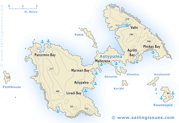
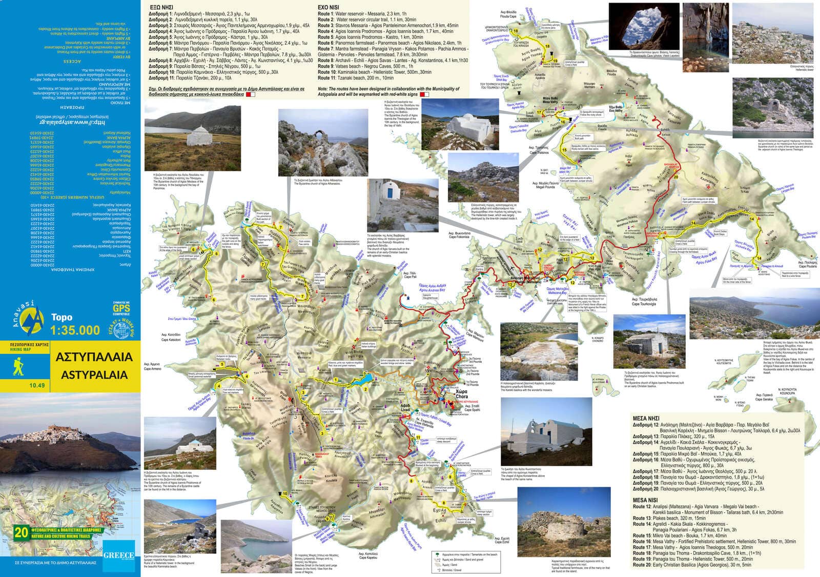
Two wide bays on the north-west and south-east sides divide the island into a higher western half and a lower eastern half, joined by the Agios Andreas Isthmus, which is only 110 m wide, even narrower than the Patmos' isthmus!
Stock farming (cheese), fruit- and vegetable-growing, fishing and, increasingly, tourism bring the inhabitants a modest degree of well-being.
- All Greek islands
- Dodecanese • Southern Sporades overview
- Chios
- Samos
- Patmos • Arki • Lipsi
- Leros • Kalymnos
- Kos • Nisyros • Tilos
- Astypalaia
- Symi
- Rhodes
- Itineraries in the Dodecanese, adjacent Turquoise coasts and Southern Sporades.
Previous islands: Kos, Nisyros and Tilos
Next island: Symi
This butterfly shaped island is one of the least accessible due to its remote location, yet also one of the most attractive and rewarding islands in the whole of the Mediterranean: cerulean water (amazing colours), a classical Chora, totally off the beaten track with reclusive and sheltered anchorages.
This fascinating island “demands” a three night stay and can best be visited during a two-week, ideally three-week itinerary from the Athens, Kos / Rhodes or Paros yacht charter bases.
Consider circumnavigating (usually anticlockwise) the island: the leg from Astypalaia to Amorgos is unique: aim for the Monastery.
Scattered over the island are some 200 little churches and chapels, most of them founded by private citizens and many of them in a state of despair.
Some of the many neighbouring rocky islets are used for the grazing of goats.
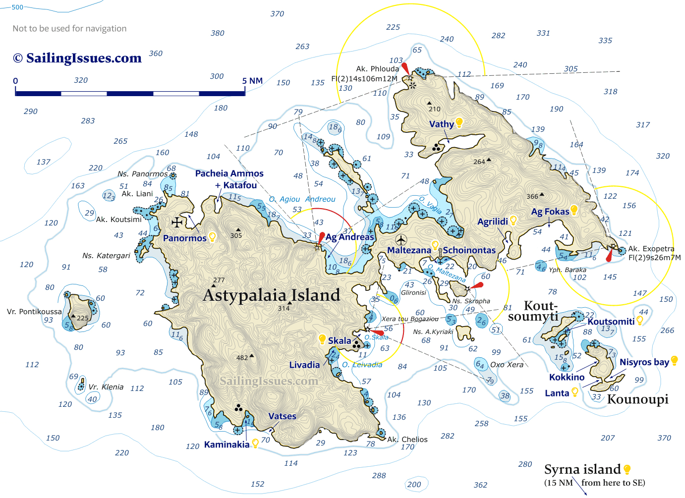
Ports / anchorages are clickable . signifies a highly recommended venue, and a truly must-see venue; see other icons. |
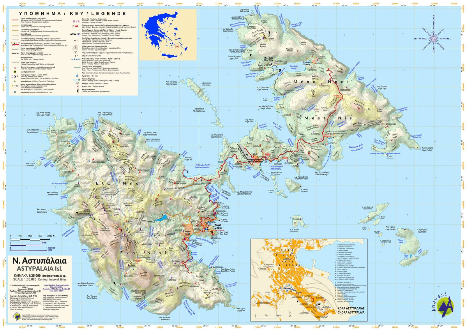
Astypalaia island
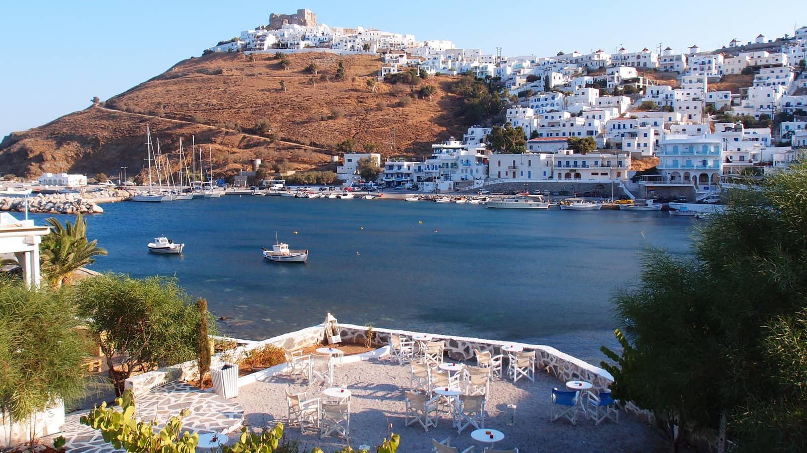
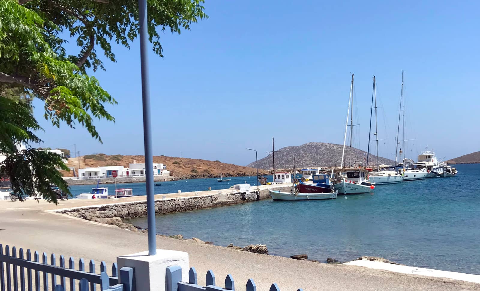
Skala (Astypalaia port)
Must-see Skála - Σκάλα alias
Péra Gialós - Πέρα Γιαλός – or without subtlety
“Astypálaia port” – is located in Pera Gialos bay alias Skala bay, see the A-Z index for other places named “Skala”.
This area is untenable in strong SE winds, and waves will easily crash over the breakwater , in which case you should relocate to Maltezana or to the north side of the island.
The L-shaped yacht harbour was finished as recent as 2007, and is an immense improvement over the hitherto anchoring in the bay. There is room for 12 – 16 yachts (depending on their sizes and whether a fishing boat comes along-side), which even in the summer is often sufficient; affordable pricing: e.g. €15 for 50 ft including water and electricity and €10 for subsequent nights. Mr Dimitris +30 6987193397 (+30 6946431685) is a restaurant owner but can assist with docking and reserving a berth, but really this is a “first come, first served” port; check the quality of the water before using it (quality varies); clean sanitary block with 3 toilets.
When you require water but there are no berths available, you can temporarily dock at the short mole to the west to fill your tanks.
On the ferry quay you can conditionally go alongside or stern-to, ideally as far west as possible; first ask Harbour Office Tel: (224) 30 61208; exposed to E – S winds and certainly a no-go in Meltemi winds. There are only a few ferry arrivals per day.
The Meltemi is strong here, often with alarming NNW – NNE gusts, anchor over sand / weed; in our experience there is not always good holding (Eagleray agrees). On the other hand, French and German guides promise excellent holding and the GWP states "reasonable holding".
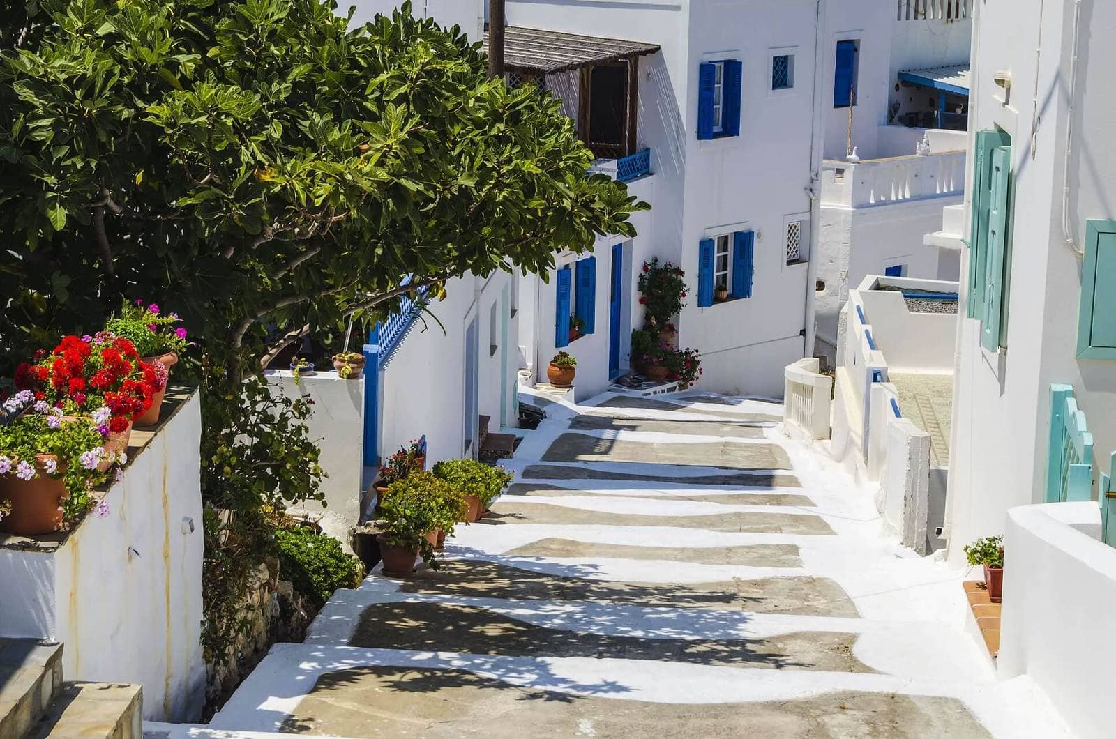
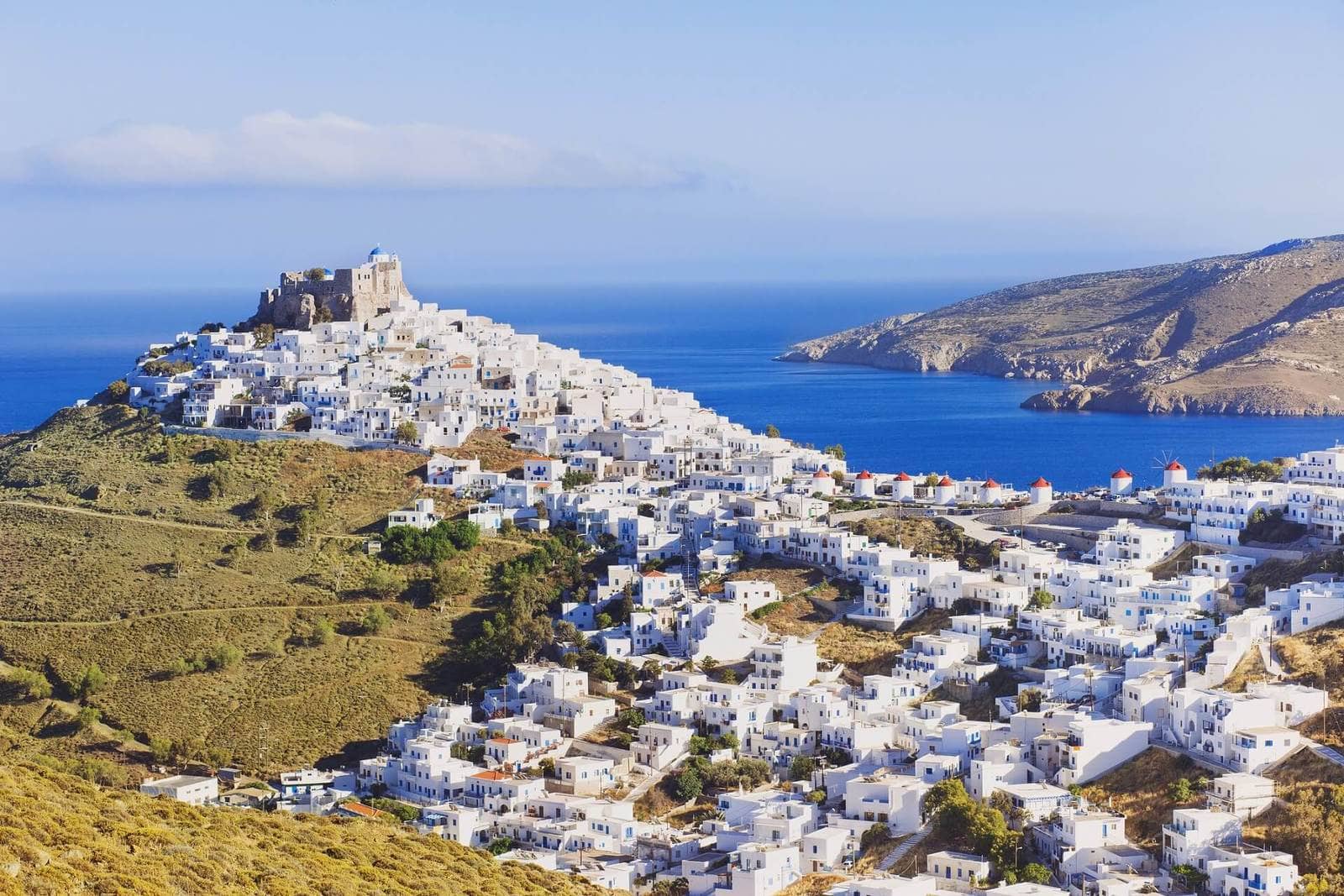
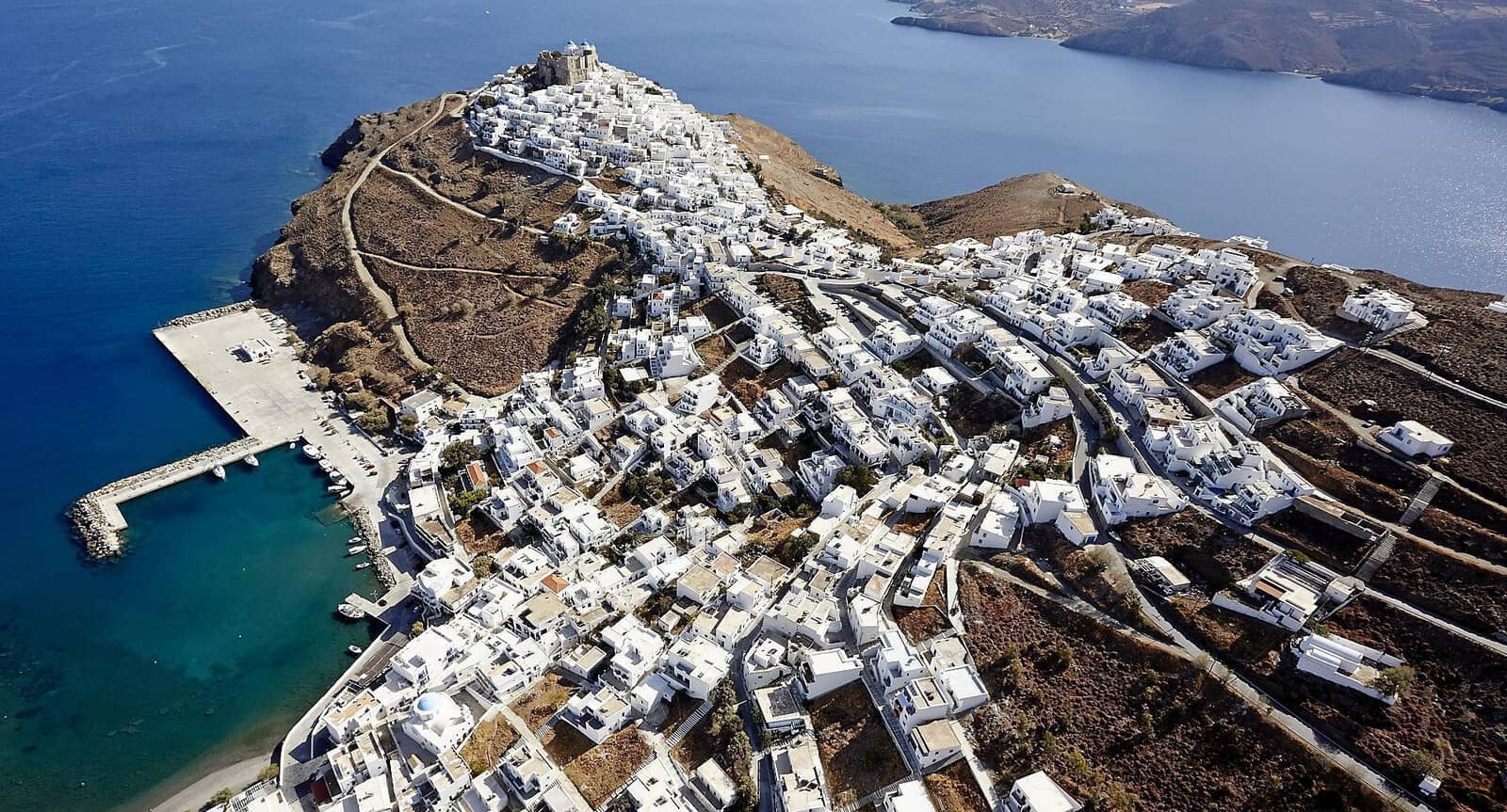
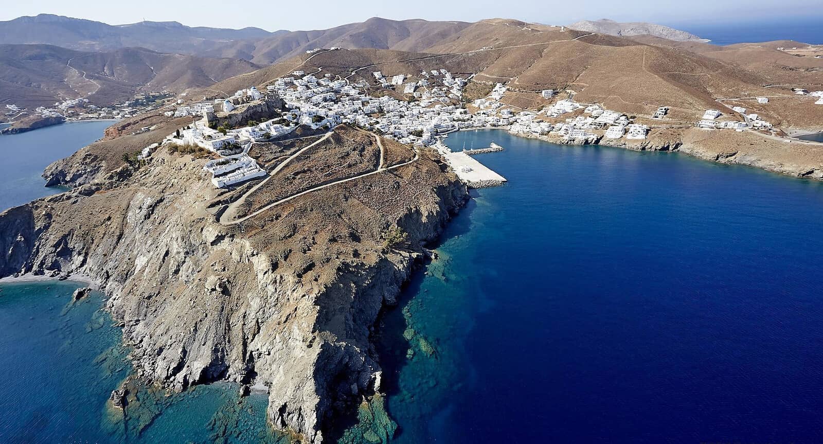
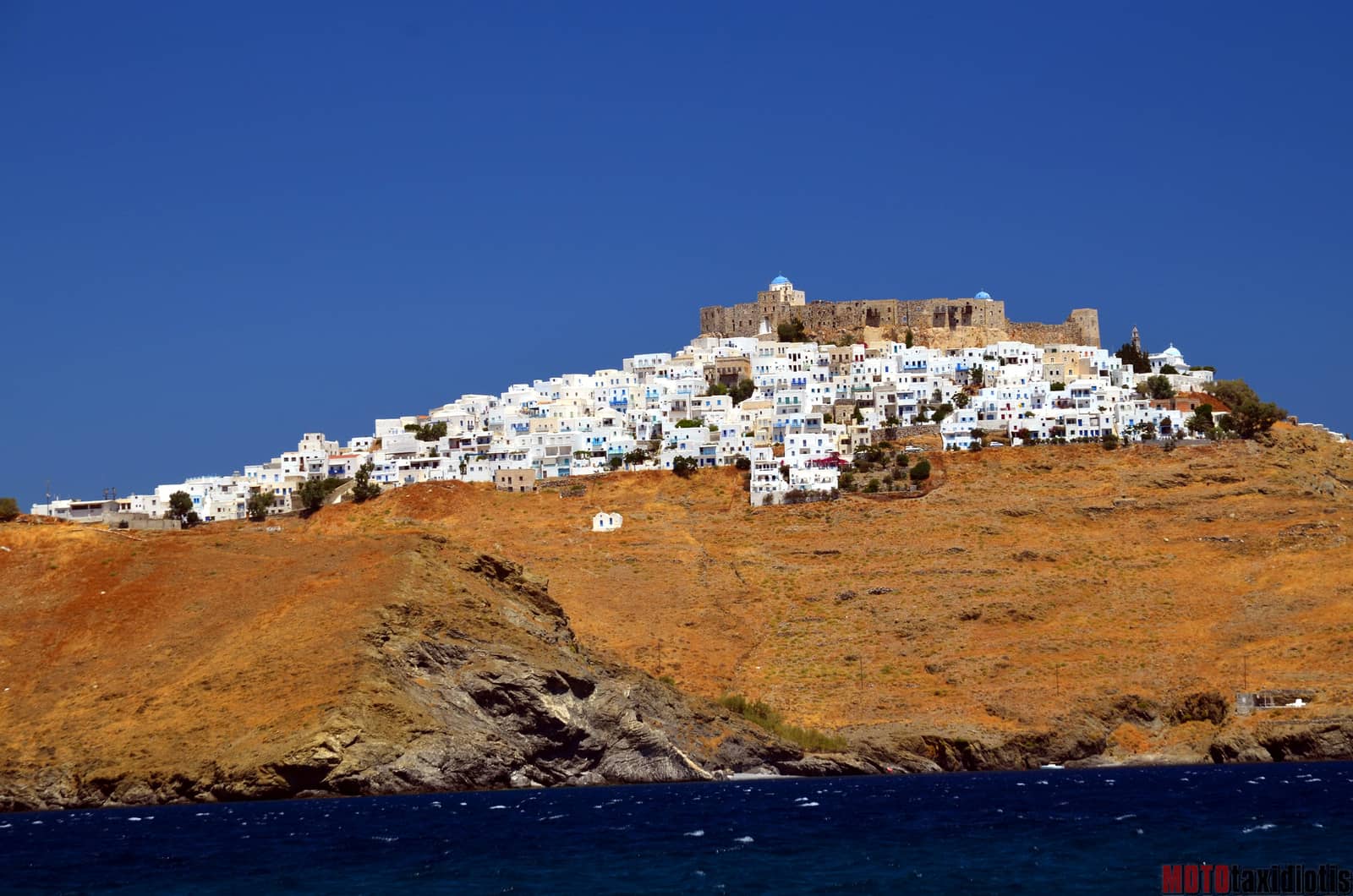
The picturesque village of Astypalea is dominated by a Venetian castle (13 – 16th c.) founded by Giovanni Querini (a Venetian official of the Duchy of Naxos), as well as two important churches that were built on ancient ruins. The blue-domed “Panagía Portaítissa” is perhaps the most alluring orthodox sanctuary of the Dodecanese. The views from this elevation are spectacular and aptly called “god's bank”.
The capital Chora is situated on a bare rocky hill above its port: Skala. South-west is the fertile Livadi valley, the island's main agricultural area.
In typical Skala (vulnerable but necessary port) and Chora (safety uphill) fashion, see toponyms, just 190 years ago the village of Astypalaia was paltry. Pirate raids prevented the residents from expanding the village outside its walls. It was only after 1829 that houses started being built on both sides of the road connecting the old port to the stronghold.
Visit the tiny archaeological museum, which opens for the summer (~mid May) every day 08:30 – 15:30, closed on Tuesdays).

Koutsomiti and Kounoupi islets in the distance.
To the right (south) Livadia bay.
Livadia
The larger bay of Livádia - Λιβάδια bay is located immediatly south of Chora / Skala, where you will find sun bathing tourists and tavernas, notably “Parathinalos” ; only moderately resort-like, and mostly in good taste; excellent bakery, fruit and vegatables ashore.
Anchor over sand in 6 – 8 m, well off the beach in the NW corner Lat Long, avoiding the swimming area when the yellow buoys are present in the height of summer. The anchorage is less exposed than you might surmise from the charts, with shelter in S – ENE winds
even in stronger northerlies including Meltemi; solid holding.
The anchorage is less exposed than you might surmise from the charts, with shelter in S – ENE winds
even in stronger northerlies including Meltemi; solid holding.
The grand vista towards the Venetian castle and the blue cupolas – also splendidly lit up at night – is the real asset of this bay.
Vatses
Vátses - Βάτσες bay and beach offer amazing crystal clear water.
Anchor at 4 – 8 boat lengths off the beach Lat Long, near the rock that divides the main beach and a smaller beach in the east; open to westerlies; you might have to try several times to get your anchor set.
Although the local beach bar has a bad reputation we encountered friendly staff who prepared us cocktails-to-go to bring on board , yet they do play loud music.
Visit the legendary Cave of Negro - Spilaio Negrou: stalacmites + stalactites = speleothems. Pirates used to hide here in the Byzantine era, and coins found in the cave are on display in the archaeology Museum in Chora.
Handy photos of the location of the entrance of the cave[in Czech], uphill north from the tamarisk trees.

Kaminakia
Like most of the south shores of Astypalaia, the bay of Kaminákia - Καμινάκια has inconceivably translucent water.
It is a slightly more popular anchorage than Vatses, as well as more spacious. Fortunately, even in the main season yours could still be the only visiting yacht; open to southerlies; anchor near the “dogleg” curve Lat Long.
Mixed experiences with “Linda's - Λίντα Restaurant” (eco-friendly and local produce) behind the palm trees ashore.
NW of the beach you will find the ruins, just 4 stones high, of an Hellenistic tower.
Panormos
As the name suggests the bay of Pánormos - Πάνορμος offers (nearly) allround protection. However, leaving & entering is dangerous in strong northerlies and certainly with Meltemi.
The west cove Lat Long offers allround shelter; excellent holding in sand (small patches of weed); close to the beach there are stone ridges (mind your outboard engine); anchor in 5 – 7 m.
Alltogether four very pretty coves where you will find total solitude. In light conditions drop anchor on any side of Panormos: the open south beach is preferred. Gusts are SE in the narrow (and shallow ) SE cove Lat Long (therefore not ideal for staying overnight), and SW in pretty much the rest of the bay.
Ashore is the white Byzantine Church of Ag Nikolaos built in the 10th century.

Pacheia Ammos + Katafou is seen behind the headland.
The west cove is out of sight on the left (NW).
Panormos bay on the right (west) is mostly out of sight.
Pacheia Ammos + Katafou
Pacheiá Ámmos - Παχειά Άμμος + Katáfou - Κατάφου is the small inlet directly east of Panormos and equally off the beaten track. Officially, the east cove is called Katafou, whereas the whole inlet is called Pacheia Ammos.
The Katafou cove is only susceptible to NW winds, and has greater depths, which allowed German naval vessels to hide here in the second World War.
The beach anchorage in the south of Pacheia Ammos is open to NW – NE winds and is more shallow; anchor in 3 – 5 m Lat Long.
The English meaning of “Pacheia Ammos” is “dense sand”: fittingly promising a nice beach.
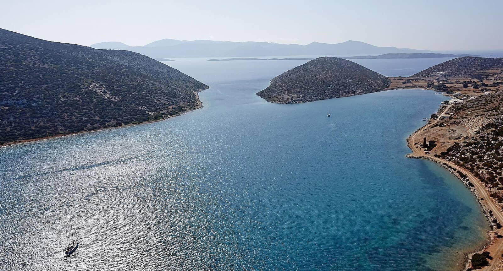
Ag Andreas
The utilitarian port of Ágios Andréas - Άγιος Ανδρέας offers excellent protection against southerlies in rather desolate surroundings
Lat Long, in northerlies you will have to ask the fishermen for a berth on the inside.
This L-shaped pier was created mainly for ferries – as a substitute to Astypalaia-Skala port in southern winds – and is rarely visited by yachts. However, the port is very useful and there is often sufficient room; good holding in sand and rocks, but we were happier alongside, indeed French and Italian guides recommend going alongside; nothing ashore except for a lustreless ice cream shop; the pier is 1,7 m above the sea surface; no longer water and electricity on the pier; crowded with travellers around ferry arrival times; quarry to the south.
A taxi to Chora (Skala) takes about 10 min.
Nectar
The word is derived from Greek νεκταρ, the fabled drink of eternal life.
The meaning “sweet liquid in flowers” is more recent and first recorded c. 1600, see mythical nectar…
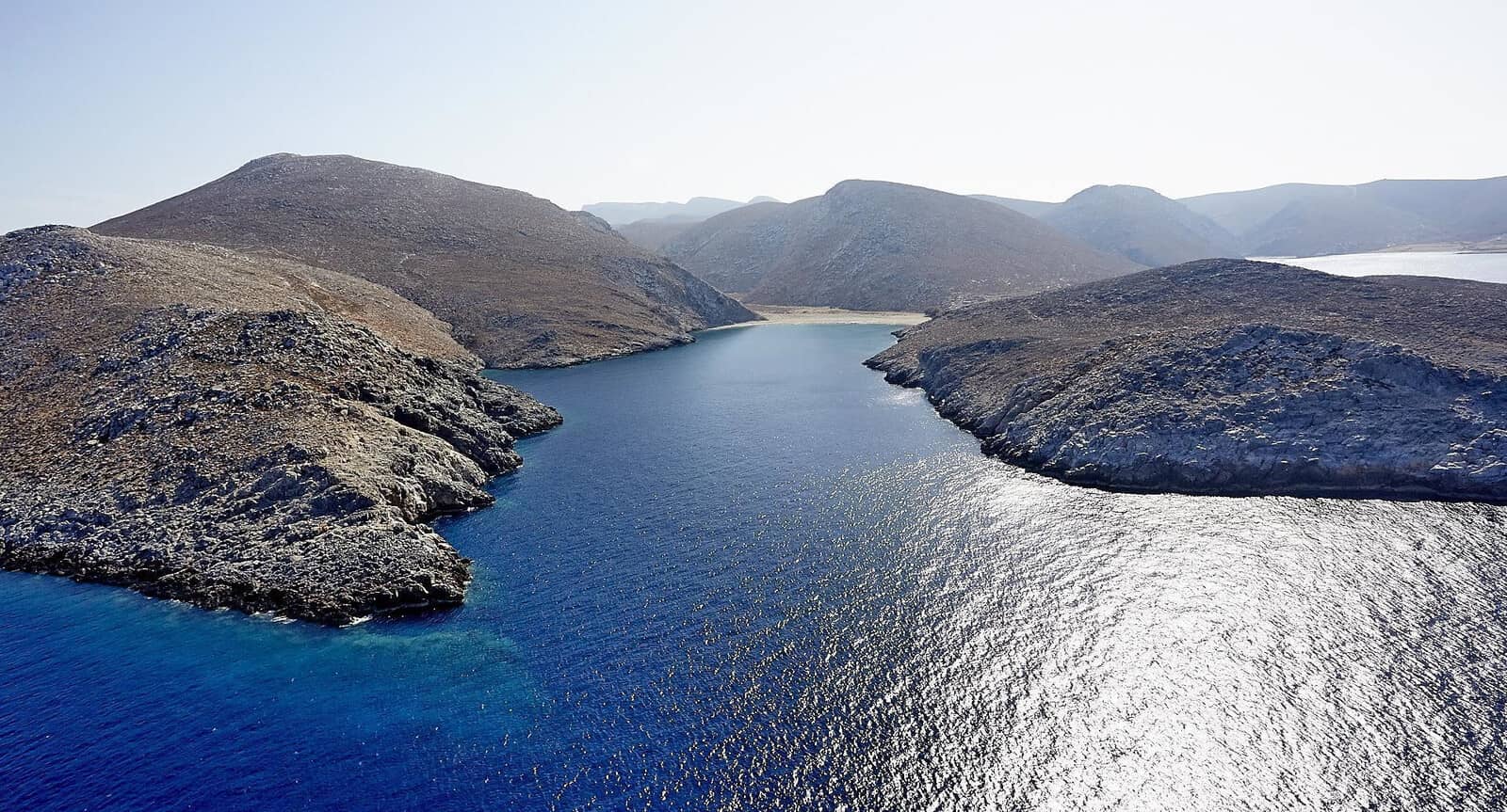
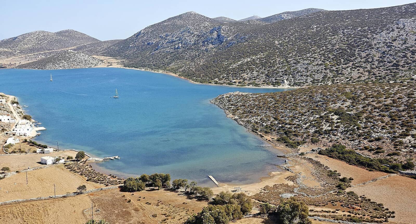
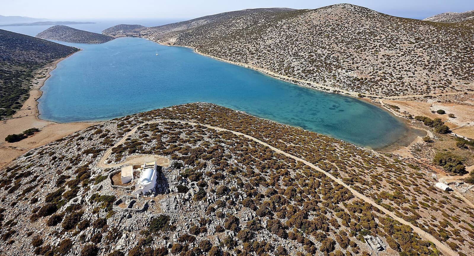
Vathy
Vathý - Βαθύ is a delightful landlocked bay Lat Long providing all-round shelter. The entrance is narrow and shallow: 3,5 m minimum (go to the north side of this small patch if necessary). Contrary to the meaning of “Vathy” the bay isn't deep.
In Exo Vathy village, in the NW corner of the bay, you can find the
Galini - Γαλήνη Ouzeri & Fish Restaurant (top seafood) located on the upper floor of the building, since in rough weather the quayside will be flooded.
The local pier and quay have depths of mostly ~2,5 m, approach with care and you can always try to go stern-to while keeping some distance, smaller yachts can go alongside.
The preferred anchorage (certainly in Meltemi) is in this west cove, but also consider the SE and E options, near (Mesa) Vathy village.
Visit the ruins of a fortified Prehistoric settlement and a Hellenistic tower on the inside & north side of the entrance, 10 min. walk, see
Vathi: a palimpsest.
The famous Drakontospilio, Drakon's cave Lat Long is a strenuous but rewarding 30 min. hike (and back).
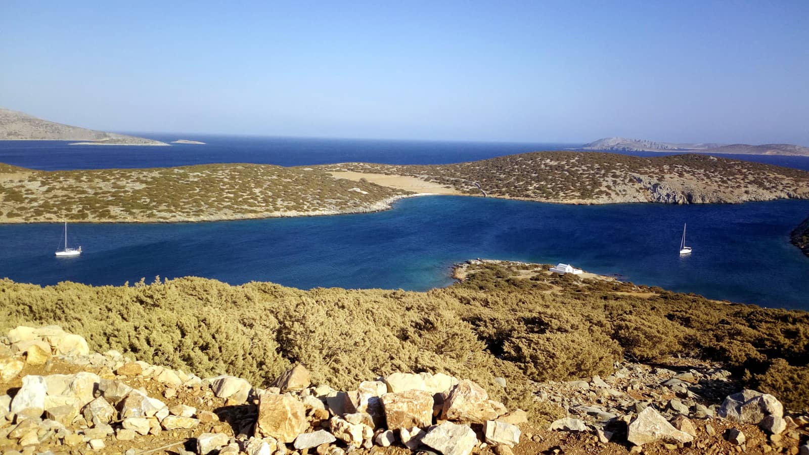
Ag Fokas
The crescentiform Ágios Fokás - Άγιος Φωκάς bay is named after the Church on the (pen)insula just to the south, and offers 3 anchorages:
- Hoylaki just west Lat Long of the conspicous Red cliff (Kokkinos Gremos) – two small ingresses both big enough for caïques+tourists, one with a beach and one with a vertical cliff face at the end.
Marvellous translucent water; good snorkelling; after 16:00 the tourists will be gone ; exposed to southerlies; safe in Meltemi; take a line to the rocks. - East shore – curved disembarkation pier, most guides mention 3 or even 4 m depth at the tip of this pier Lat Long but it seemed shallower so we didn't give it a try.
- Vlichádia - Βλυχάδια bay is at the south end the bay and is the preferred spot Lat Long in southerlies; open to W – NE winds; the thick weeds make it difficult for the anchor to catch, suspect holding.
Note that the GWP misidentifies “Agios Fokas” as “Vlikadha” and also overlooks the 'iota' in “Vlichadia”.
Agrilidi
Agrilídi - Αγριλίδι is a lovely elongated and deserted bay with nothing ashore except some modern ruins and two Churches. Despite that this bay is traditionally seen as one of the best anchorages, we dragged our anchor on each occasion (windier conditions). The preferred spot is near the pebbled beach Lat Long, but you can anchor really anywhere; gorgeous turquoise sea; this is a wonderful anchorage if your anchor holds.
Directly south of the Agios Nikolaos Church is a sunken crane (barely visible now; two metal wheels are above sea level).
Larger yachts: mind the Baraka reef (4.5 m depth) on the approach from the east.

Maltezana (Analipsi) + Schoinontas
The mini-port of Maltezána - Μαλτεζάνα (sometimes labelled Análipsi - Ανάληψη after the adjacent village), alongside the bay of Schoinontas, are both set in a fertile valley with verdant tree lined beaches.
The name Maltezana alludes to the Maltese pirates who used to have their lair here.
The name Analipsi means Ascension, i.e. entering heaven alive.
Note that Schoinóntas - Σχοινώντας bay is called “Skhinounda”? in the GWP.
Each of the Maltezana and Schoinontas bays provide all-round shelter; particularly useful in Meltemi since you will experience surprisingly few gusts here (which will be from the north).
The best option is the pier in Maltezana, however if you want to stay at anchor avoid the Maltezana bay and aim for
Schoinontas instead; mind the extensive weeds though, mainly in depths >4 m; anchor over sand in the shallower parts Lat Long.
In Maltezana go alongside the pier Lat Long; we never needed to raft up alongside, there always seems to be room. The last third section (near the green light) has sufficient depths; water on the pier is not potable. The east side is reserved for the fishermen, the west side is free.
From the praiseworthy “Almyra” - Αλμύρα restaurant you can keep an eye on your yacht; no swell; 2 mini-markets; delicious breakfast at the local bakery; water point east from the pier; no electricity; bus to Skala twice a day €5 in the summer.
Take care to avoid the permanent moorings in Maltezana bay: anchoring is best done at some distance or in Schoinontas.
Syrna island
The small island of Sýrna or Sirna - Σύρνα, earlier known as Ag Ioannis - Άγιος Ιωάννης provides all-round shelter and lies deliciously remote Lat Long : 35 NM west of the south cape of Tilos and 20 NM SSE of Skala, Astypalaia.
Aside from a herd of goats and two Churches, see Youtube 4k and Wiki, there is nothing ashore to explore, except a hike to the highest point of 322 m through the phrygana scrubland.
Syrna features rugged cliffs around the NW side, phenomenally clear water, and is majestically off the beaten track, with two solid anchorages: Agios Ioannis and Avlakas (plus a lunch-stop option in bay Ag Georgios).

Ag Ioannis (Katholiko)
Ág Ioánnis - Άγ Ιωάννης or Katholikó - Καθολικό is a three-pronged bay on the south side of Syrna island. Use C-Map or Eagleray and not Garmin; very deep to take lines ashore; no phone reception.
Gusts are from the NW, in which case you should aim for the north cove Lat Long.
Exposed to ESE – WSW winds; difficult to find rocks to take a line to; there is a permanent mooring used by fishermen in the NE cove, to ask is free (purchase some scrumptious fresh fish in the process).
The west cove of Agios Ioannis (St John) bay is useful in westerlies.
The second anchor bay is on the SE coast of Syrna is St George - Αγ Γεωργίος bay Lat Long and can only be used in light conditions (lunch stop), open to southerlies; anchor over sand and lots of rocks, be sure to use a trip line!
Avlakas
Ávlakas - Αύλακας is
a narrow bay on the west side of Syrna island, with a stretch of imposing steep cliffs on the north side.
Eagleray mentions: "difficult to get the anchor to catch in the weeds"; once through the weeds, the seabed is sandy with some rocks.
Rather than drop anchor at the head of the bay, either go in the east cove Lat Long, which is a bit more exposed but with excellent holding in sand,
or go on the opposite side with nearly allround shelter in a minuscule cove Lat Long.
There is a disembarkation pier used by the shepherd, and ashore there is an unkept animal shelter.
Kounoupi islet
The islet of Kounoúpoi, Kounoúpi or Kounoúpa - Κουνούπα lies a mere 2.5 NM south of Ag Fokas bay, Astypalaia, with its neighbour Koutsómiti islet to the north.
Note that day trip boats and caïques bring tourists from Skala to these crystal clear waters, so both these islets (especially Koutsomiti) are not as delightfully desolate as Syrna island.
Nisyros bay
Nísyros - Νίσυρος is the charming bay on the east side Lat Long of the sandbar that connects Déma peninsula to Kounoupi isle.
Anchor over sand in 5 – 8 m; weeds in the deeper parts; although the GWP seems to disagree we found it very Meltemi (NW) proof. In N – E winds you can take refuge in either Lanta or Kokkino.
The day trip boats' permanent moorings that could be used during the night have disappeared (concrete blocks were proven too light anyway), but there is solid holding in sand though.
Very attractive curved cliff formation; pleasant beach with an Hawaiian style bar (ramshackle) on the sandbar.
Lanta
west of the sandbar is Lanta (sometimes Lada) - Λάντα bay Lat Long, which is the second best anchorage on the island, yet the preferred spot in NE winds.
Most tourists and day trip boats will gather here, and in summer there is even a jetty to the sandbar;
mind the rocks on the north and south sides; anchor in 3 – 6 m over sand and weed patches; open to S – NW winds; snorkelling near Déma.
Kokkino
On the west coast Lat Long of Kounoupi islet lies Kókkino - Κόκκινο bay, where there is no tourism even during the day. The name "Kokkino" means “red” and refers to the minerals in the rocks, see e.g. Akrotiri, Santorini.
There is less shelter, since open to S – NW winds; a relative deep bay, so anchor close to the shore in 5 – 7 m over sand, also to avoid the weeds; mind the rocks and stones near the shore; poor holding in places, but plenty of options to take a line ashore; snorkelling in the south corner; NW winds create dangerous seas.
Kokkino bay is just visible on the west side of Kounoupi.
Cape Cheilos (south cape of Astypalaia) in the distance.

Moni islet in the foreground and Agios Fokas bay, Astypalaia in the background.
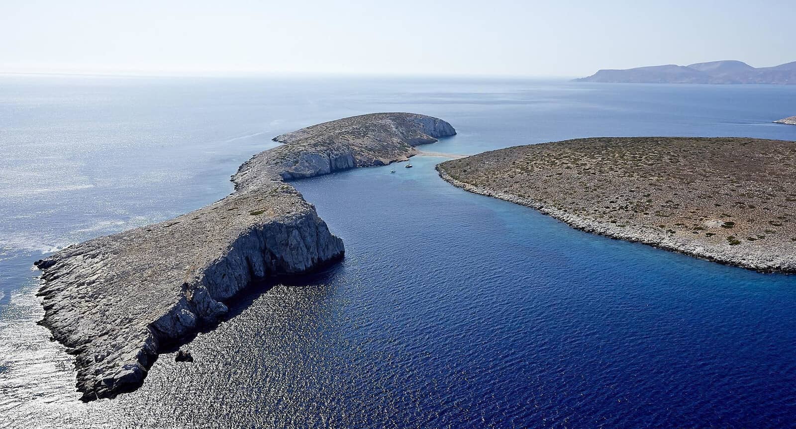
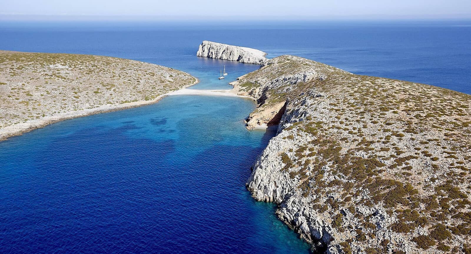
Koutsomiti islet
Koutsomyti
The islet of Koutsomýti(s) - Κουτσομύτι(ς) – which lies just north of Kounoúpi islet – is connected by a reef to the islet of Tigáni - Τηγάνι that literally means “frying pan” .
Anchor either east Lat Long, or west of the reef, over sand and slabs of rocks.
When the daily caïques have left at ~16:00, visiting yachts can use their permanent moorings – which were removed last season, but 3 buoys now reinstalled – until the next day ~11:00.
Reportedly there is a possible passage (>2 m depths) through this strait: ill adviced.
Currents up to 2 knots can run opposite of the wind direction, therefore if the wind drops this current can carry you onto the reef.