Rhodes sailing holidays
Rhodes - Ρόδος, the largest of the Dodecanese and the fourth largest Greek island (after Crete, Euboea and Lesbos), is a favourite port when visiting the south east of Greece and a very good starting point – much like Kos – for a sailing holiday in the Aegean sea.
The island is roughly ellipsoid or diamond-shaped and a mountainous range runs from north to south with the highest peak Mt Ataviros (1205 m), situated in the middle of the west coast.
British Admiralty Charts 1055, 236

Unlike many of the other islands in this region, Rhodes is fertile not only in the valleys but also on the higher slopes: pine, orange, olive, lemon, fig and pear trees thrive in these conditions.
Likewise the villages are lush and colourful with hibiscus, jasmine and bougainvillea, which explains the many butterflies.
And indeed, Rhodes is often called the butterfly island.
History of Rhodes
Rhodes was first inhabited in the Neolithic era. A major milestone in the island's history, which affected the fate of the other Dodecanese as well, was the founding in 700 BCE of the Dorian Hexapolis, a union of its three cities with Knidos, Halikarnassos and Kos.
Its economy and culture continued to flourish until the 3rd century BCE, when it was the predominant power in the Aegean.
When, a thousand years later in 1309, it fell into the hands of the Knights of St John, it became again the centre of power, symbolised by its magnificent medieval town and the imposing castle and palace of the Grand Masters.
Ports & anchorages
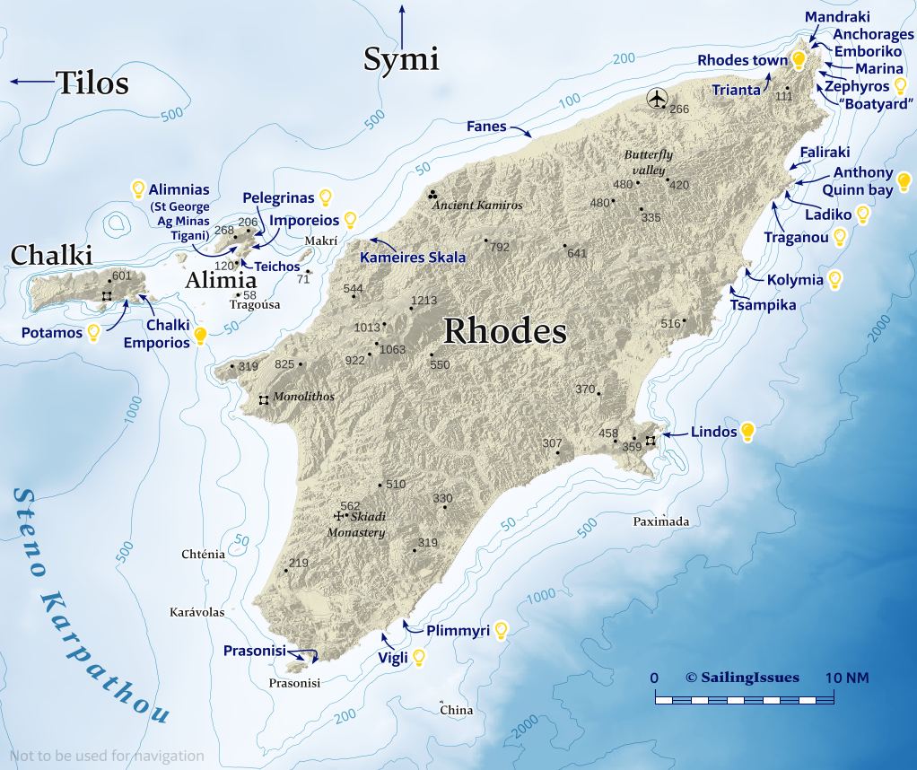
Ports / anchorages are clickable .
British Admiralty Charts 1055, 236. signifies a highly recommended venue, and a truly must-see venue; see other icons.
Rhodes island
Rhodes town

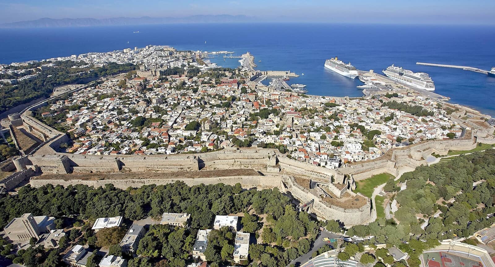
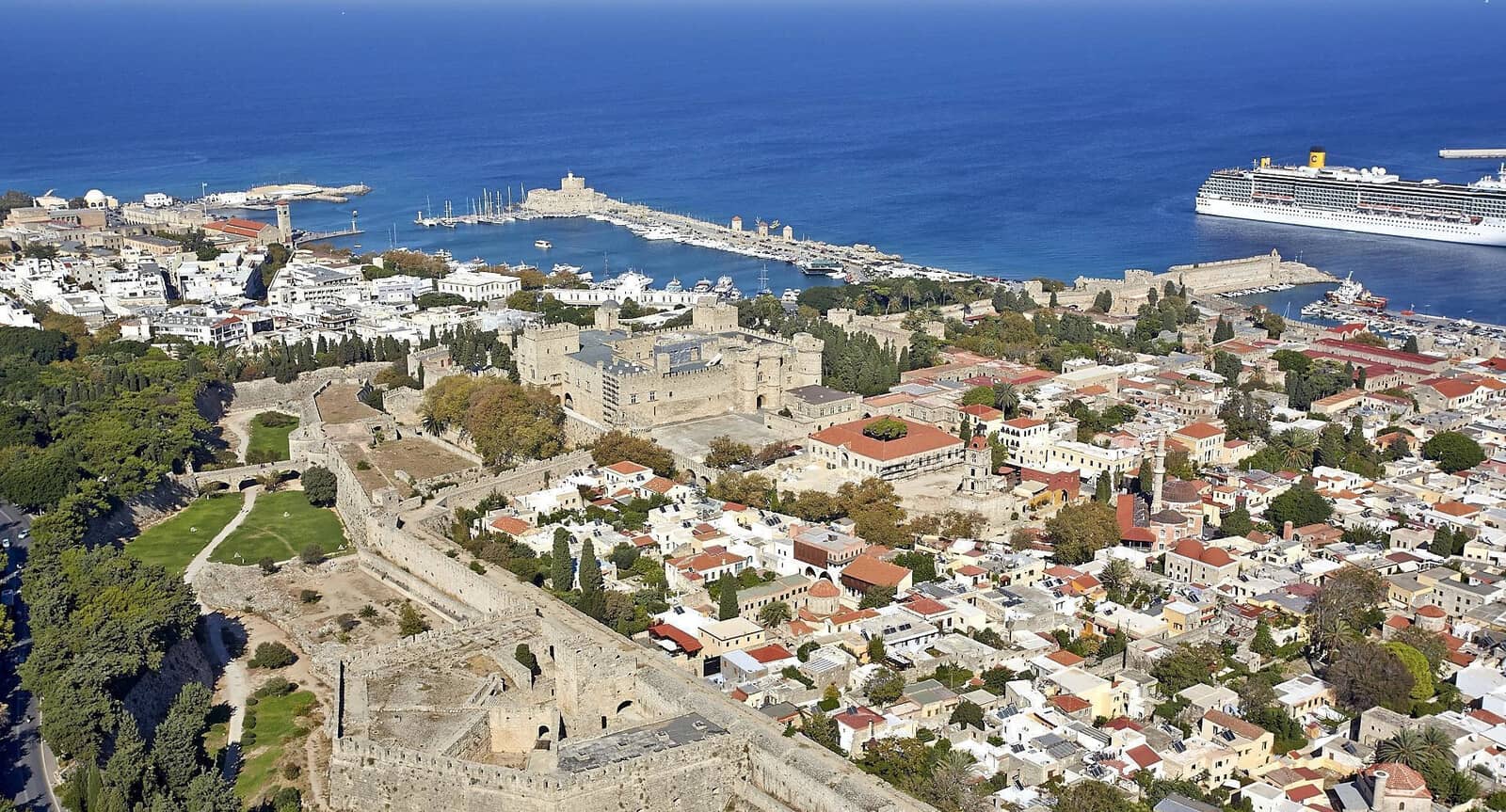
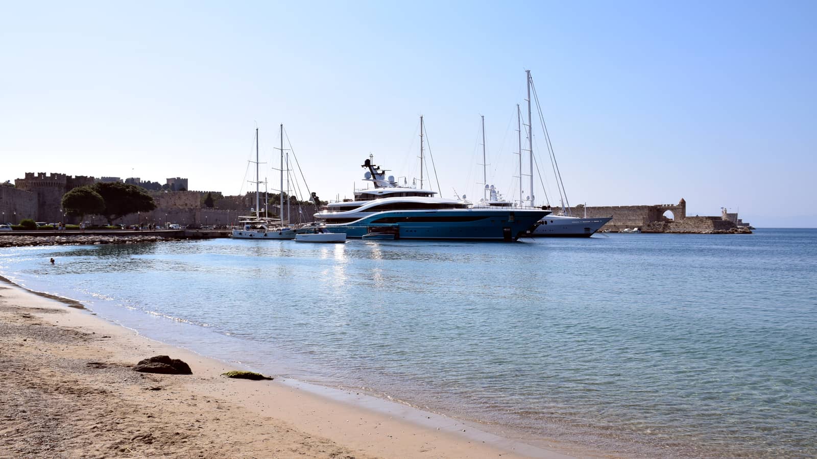
The capital, also called Rhodes, occupies the northernmost tip of the island. There are in essence three cities on this site – modern, ancient and medieval.
The modern town has a cosmopolitan character, many late 20th century buildings and hotels.
The ancient town, which was founded in 408 BCE according to plans by Hippodamos of Milesios (the first town planner), started from Monte Smith hill - Ágios Stéfanos where the acropolis stood and extended as far as what is now the medieval city.
On the acropolis the ruins of the temple of Apollo, the stadium, gymnasium and odeon have been restored.
The medieval city is still surrounded by the high walls erected by the Knights of St John. It is divided by an inner wall into two unequal parts, the smaller Collachio and the larger Burgo or Hora. Collachio is further split by the Street of the Knights, both of whose sides are lined with the sombre stone facades of the Inns of the Tongues or nationalities that belonged to the order of the Knights.
On the approach of Rhodes town you will get a first glimpse of the massive Old Town walls together with the graceful minarets, mosques and the arcaded waterfront markets with their exotic scents.
Available on the entire island island of Rhodes: ABC Groceries delivered to your yacht.
Prevailing winds in the Rhodes' ports are W – NW; large waves in NE; avoid entering / leaving port in strong SE.
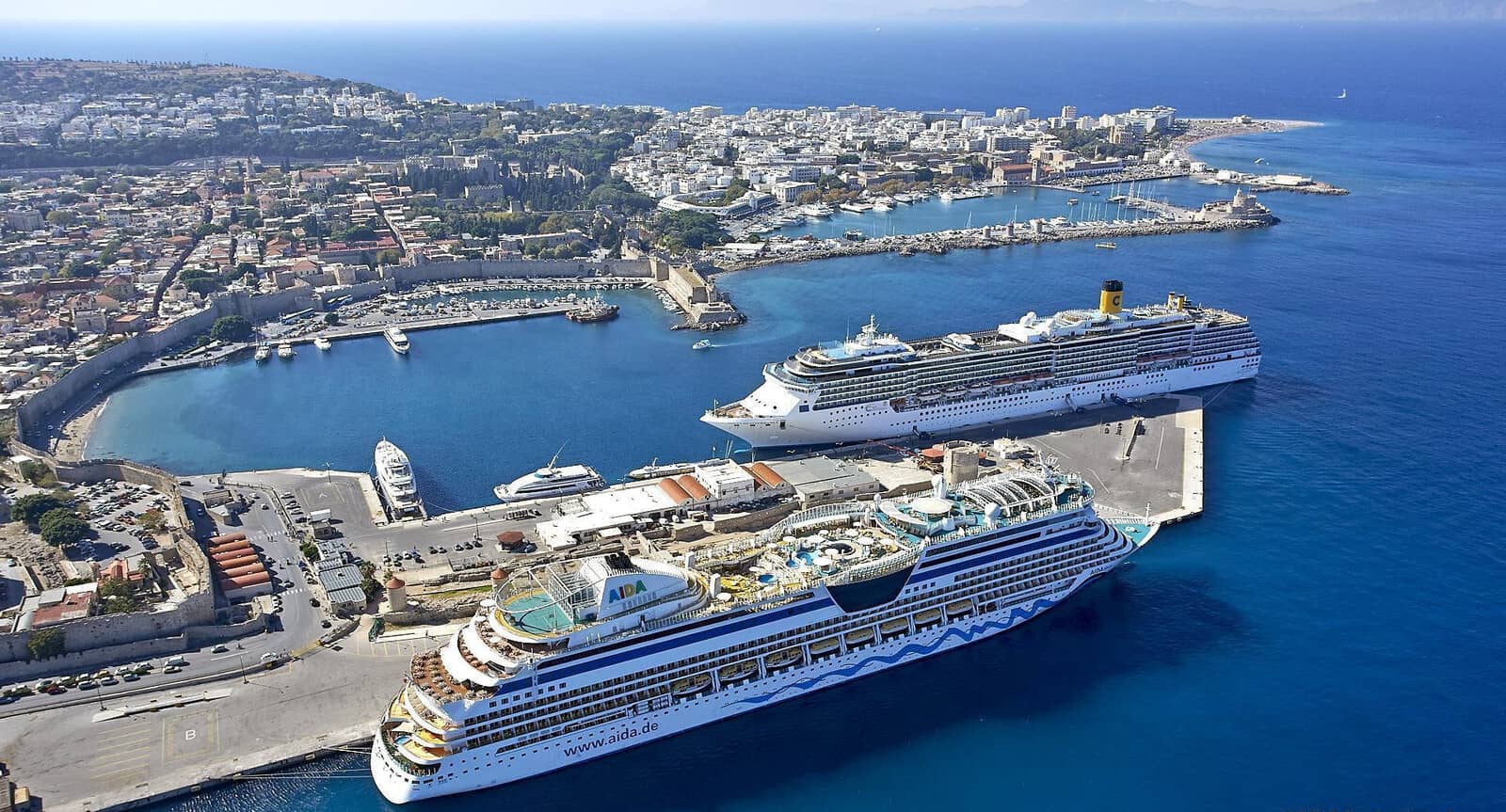
The front cruise ship is docked in the Cargo & Ferry Port: “Akandia”, the other cruise ship is docked the in Emporiko / Commercial port with opposite, on the town quay, the superyachts.
In the distance is Mandraki port.
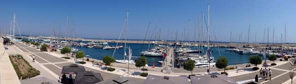
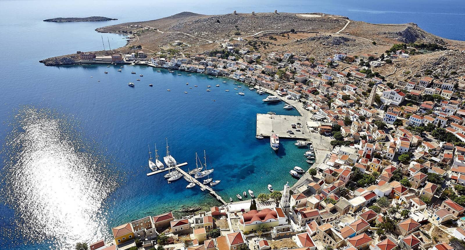
Mandraki
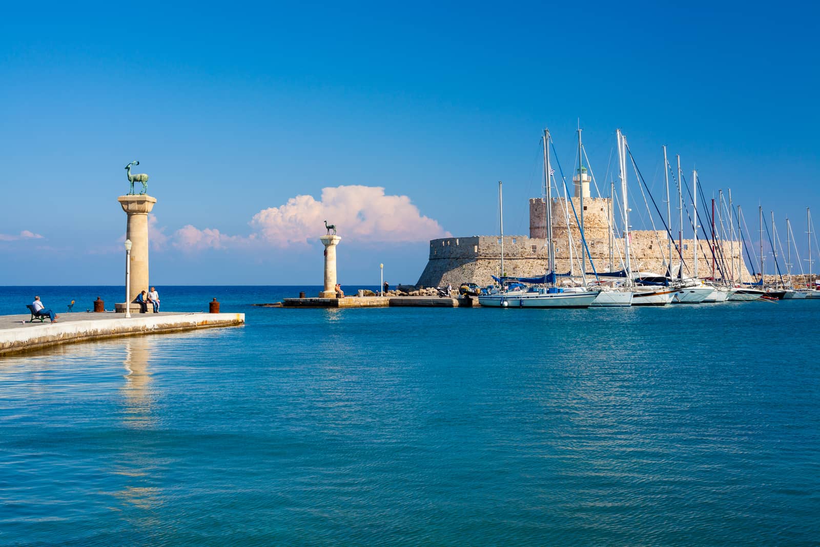
The port of Mandraki - Μανδρακι – which was the main harbour of Rhodes town for almost 2500 years – now regards itself as “Marina” Mandrakiou - Μαρίνα Μανδρακίου, although as yet few additional facilities have been introduced; Mandraki Harbour Office VHF 12.
Reserve a berth – must be >48 hrs in advance – preferably via Mr Georgios +30 6936795114 (whatsapp) or info@rodosmarina.com,
rodosmarina.com VHF 9, alternatively via the local agencies:
Bluebonnet Maritime VHF 77 callsign “Maritime”
or
Mr Roditis Roditis +30 697 4447720
or
A1 (also for repairs) VHF 73 callsign “A1 Yachting”
or
Navigo VHF 6, (do request fee confirmation via txt message to have it in writing).
The harbour is miserably overcrowded in the season; even visibly vacant berths are vigorously guarded by irascible gentlemen ; go stern-to (or bows-to) where directed; visiting yachts will usually get a berth in the NE corner.
The area near the 3 wind mills is rented by charter fleets and certainly monopolised Friday – Monday, therefore plan to explore Rhodes town during the mid-week, else opt for the Marina.
Excellent holding, yet fouled anchors are customary here and anchors will cross, use a trip line when possible.
Mercifully, more and more berths have laid moorings.
Embrace the Mediterranean styled chaos of this “marina” (aside from the bad-mannered characters).
There is a chain (for the laid moorings) that runs parallel along the quay about 30 meters off the seawall, also in the NE corner, so drop anchor as far out as possible.
The town quay is reserved for local ferries and hydrofoils. Visitors can also go on the square block on the west side, if there is room.
The T-shaped pontoon on the west side of the harbour has been gone since 6 seasons, which is correctly shown on C-Map, openseamap and in the GWP, but not on Eagleray, Garmin, etc.
A whole series of new pontoons are projected (years ago) throughout the harbour and as soon as these are effective I will forthwith omit the quotation marks around “marina”.
Justifiably, Mandraki can offer the most desired berths in Rhodes' town: safe and preciously located near the Old Town and at the historic site of the Colossus.
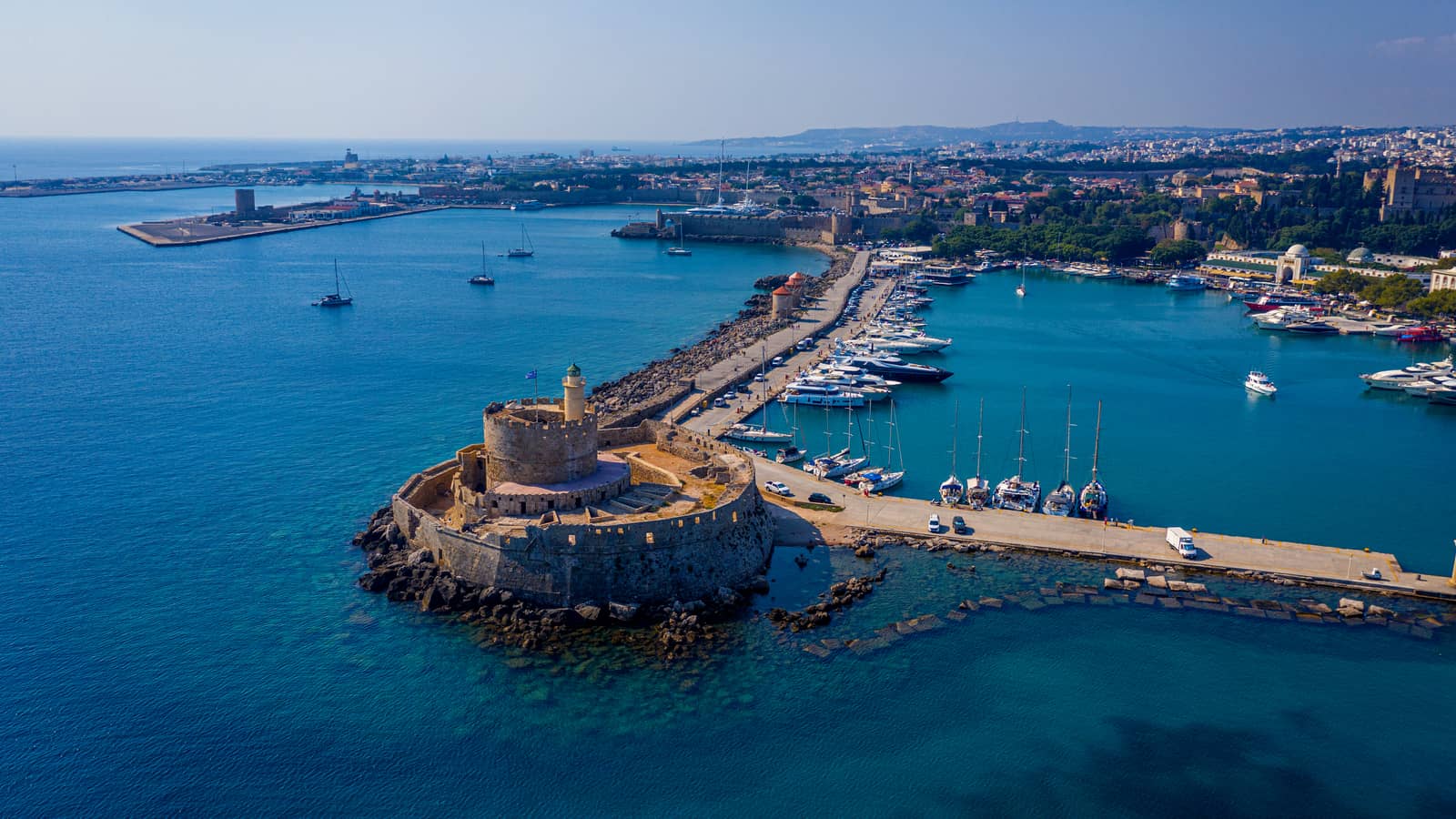
Behind the De Naillac Tower there is the quay for the 20 – 45 m yachts.

Commercial harbour / Emporiko Limani
Watched over by the mighty UNESCO-listed city walls – and south of the Mandraki seawall – is the second port, Emporiko Limani / Commercial harbour with berths on west side, across from the giant cruiseships.
Although this quay is targeted for vessels 20 – 45 m in length, smaller yachts are accepted when there are vacancies; make a reservation via one of the agencies.
Shelter in SE – W – NNW winds; it helps to be tucked in between a couple of superyachts and megayachts.
Swell from northerlies or the surge from cruiseships can mean an uncomfortable stay.
Large waves in N – ENE winds, i.e. 1.5 m in 8 Bft N.
A couple of tugs and ferries will use the northern section.
Note that the third and largest port is also dubbed Emboriko or Emporiko, but this is officially the Cargo & Ferry Port: “Akandiá” Εμπορικό Λιμάνι «Ακαντιά». No-go
Marina
The freshly in 2015 opened Marina of Rhodes provides reasonable services and shelter for yachts up to 25 m. High-priced, even for Greece: few facilities (it remains unfinished?) and already signs of wear and tear; very friendly staff and excellent assistance while mooring; very small toilet-shower block, 3 WC and 2 showers – second sanitary block is work in progress; excellent Wifi signal; nearby mini-market overly expensive.
Some berths are affected by strong N or S – E winds: rolling reportedly resulting in damage; seagull guano on docks. The Old Town is a 15 min. walk NW.
rhodesmarinas.com – Marina Rhodes VHF 71.
Rhodes' town anchorages
 Just east and outside of Mandraki – at the wind mills – where there is room for about 12 yachts, plus the occasional tourist “submarine”, one is yellow . Officially not allowed, but often condoned. Wash from cruise ships.
- At the beach in the south of Emboriko over sand and weed; permission is needed from the Harbour Office; wash from cruise ships and exposed to various wind directions; don't obstruct the manoeuvring tugs; swell and large waves in strong northerlies.
- Loutrá Kallithéas / Zephyros beach: immediately SW of the Marina over sand and better in northerlies than in the marina. Consult Eagleray and Garmin; excellent holding and plenty of room to let all of your chain out in stronger winds; open to NE – S. There is a no-anchoring zone indicated by black pilar buoys (removed during winter months?).
Visit the adjacent Orthodox / Jewish / Muslim / War cemetaries and park and good “SURPRISE BAKERY & CAFE” to the north; decent sandy beach.
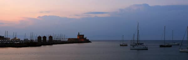
regard the conspicuous 3 windmills and St Nicholas Fortress. Hi-res image
“Boatyard”
No-go 1 NM south of the Marina is the “Boat Yard” or “A1 Yachting” Lat Long. The area is in shambles with derelict ships along the quay near the crane, a refugee camp, high prices, zero amenities; far from shops, etc.
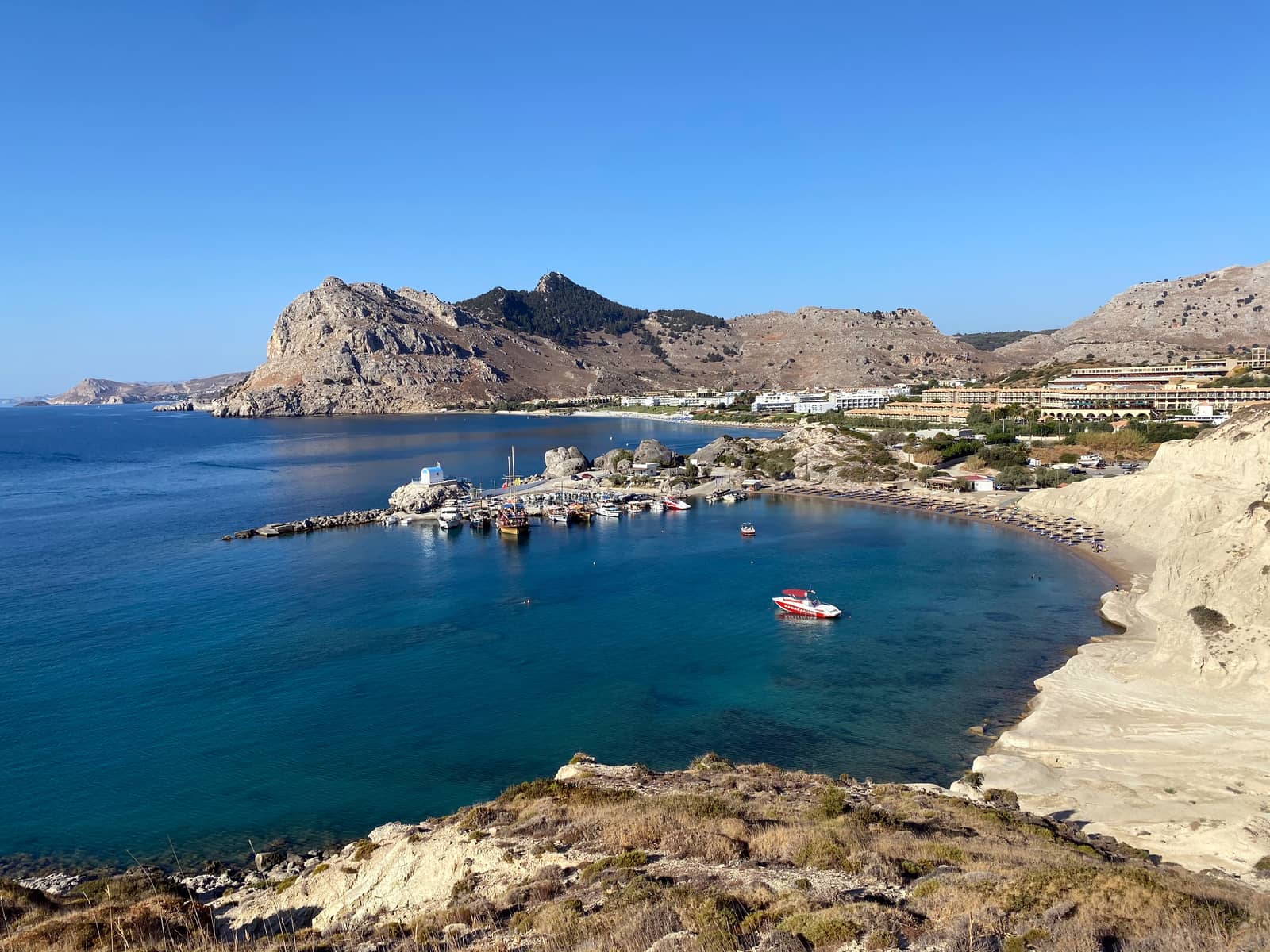
Faliraki
No-go The port of Faliraki - Φαληράκι – 1 NM north of Anthony Quinn bay – is swamped with tourists; the basin has depths of 1.4 – 2.1 m Lat Long; always packed with local craft; uncharted shoals, rocks and hazards in the approach. To the north in front of the beach solid holding in sand, but too many power boats, disco music, and bouncing castles afloat.

Anthony Quinn bay
Anthony Quinn bay is the prevalent name for what was originally Vagíon bay - Όρμος Βαγίων Lat Long [immediately north of Cape Ladiko].
How this idyllic, hardly built-up, rocky bathing bay with crystal clear water got renamed is not documented, however
the various stories agree that after the shooting of the film The Guns of Navarone (1961) – which took place partly in the bay – the actor Anthony Quinn bought land here or it was given to him.
What followed is contested, see
“The Real (?) Story Of Anthony Quinn Beach”.
The seabed gets rockier closer to the beach: anchor in 8 – 10 m with lots of chain over sand; good holding in splendid setting.
During office hours in the high season you will be packed in like sardines; fortunately, the caïques and tourists are all gone by 17:00, already at 16:00 it will become bearable; amazing “Kounna Resto Bar” at the beach, and mojitos near the small pier in the east.
We experienced several sudden nightly gusts <20 kn from the south; the area north of Cape Ladiko is not fully charted.
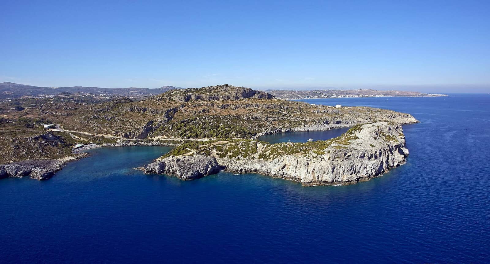
Ladiko
Ormisko (little bay) Ladikó - Λαδικό is the quieter and less grand alternative to Anthony Quinn bay plus suitable in northerlies with shelter from SW – ENE winds.
Mind the shallow reef – minimum depth 1.2 m – in the middle of the entrance, the western approach is both wider and deeper.
Closer to the shore there is less sand, more rocks; anchor in 4 m Lat Long; beware of a rocky outcrop and shoal close to the east side, which is ideal to tie a line to.
Tavernas ashore.
To the south is a really small cove that looks tempting, bottom is largely rocks though; both a tripline and a line to the shore are needed here.
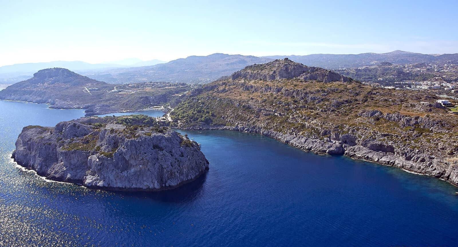
Ladiko bay is behind the headland, across the low isthmus.
The shallow reef in the entrance of Ladiko bay is clearly visible.
Traganou Cave
In calm or stable weather it is possible to anchor at the Traganoú Cave - Σπήλαιο Τραγανού Lat Long, 1 NM south of Ladiko bay. The cave isn't particularly spectacular, yet brings out quite a few tripper boats and tourists in summer, very passable surroundings and beach.
Note that there is a no-anchoring zone near the beach, anchor in >8 m depths; excellent holding in sand.
Kolymia
The tight bay of Kolýmia or Kolýmbia - Κολύμπια, with its mini port Lat Long, provides practically allround shelter.
Avoid the shallow rocky ledges on either side of the entrance.
There is only room for a handful of visiting yachts to swing at anchor over sand / weed and some rocks and mooring lines on the seabed. Occasionally it is possible to go stern-to the outerside of the mole, though most of it is earmarked for local daysail caïques. The inner port basin is too shallow for yachts / catamarans.
Except in southerlies you can take a line to the rocks under the cliff.
Zeus supermarket (850 m inland) and a few tavernas ashore, aim for Taverna Grigoris, which is very close to a must-see family run “Rodos Nature Museum”.
The place certainly has its charms plus a fascinating recent history. Moreover, you will likely be the only visiting yachtsperson.
A big negative factor during the summer months is the endless array of hotels on the beach, the “pirate ship”, and the speedboats pulling floating toys around – there must be more than 20.
The village started with a planned – note the rectangular road grid, the canal network and e.g. the Eucalyptus road – Italian agricultural settlement under the name “San Bernedetto” (Roman Catholicism) in 1938 for pioneers from Tuscany and Sardinia. After World War II the Church (and decimated flock) was converted to Orthodox Catholicism . The central building complex served as a sanatorium until mass tourism in the 1980s discovered the beach.
The water for the Italian canals is channeled from the Seven Springs Efta Pigis [in French], a bird sanctuary 4 km west via the Eucalyptus road, well worth visiting.
Kolymbia [in German] roughly means “a place to swim”. Tantalising idea: the Latin columba “dove” could be a borrowing from Greek κολυμβάω “I dive”.
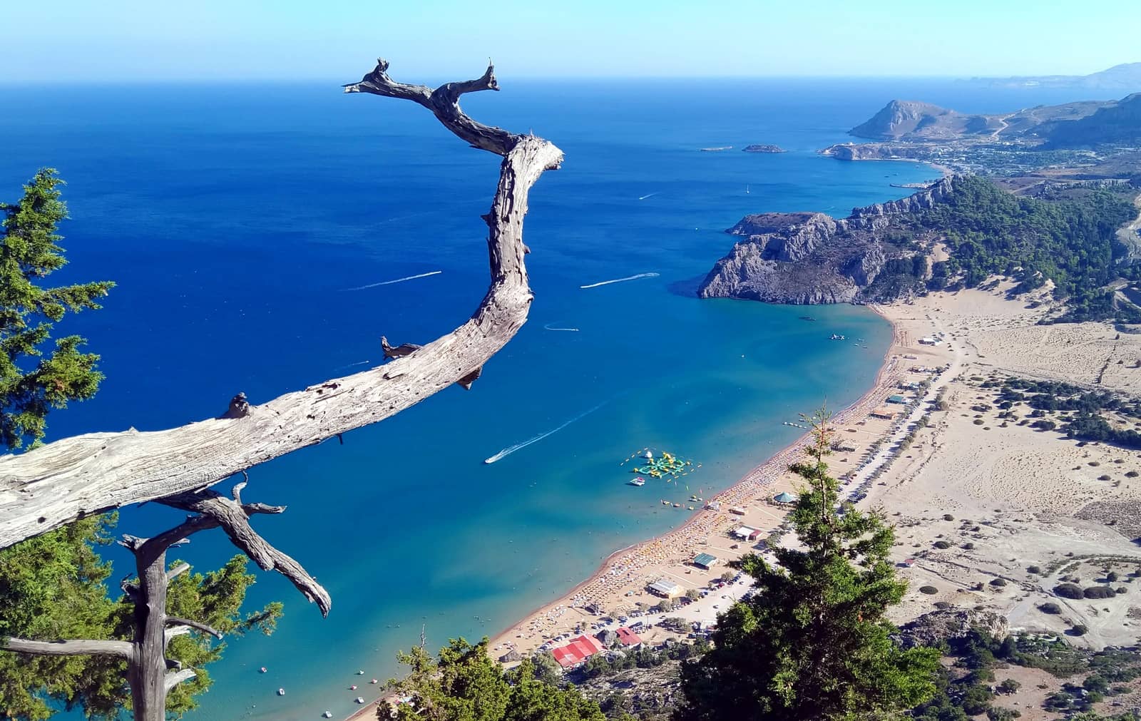
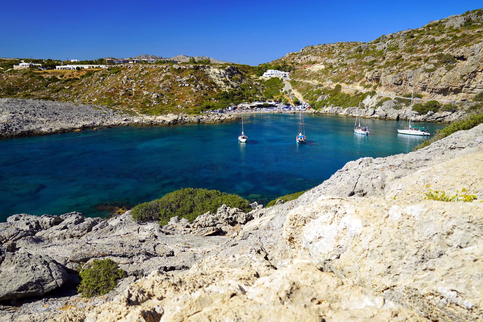
Tsampika
The northern edge of Tsampíka / Tsambíka beach - Τσαμπίκα offers a decent anchorage Lat Long under the lee side of Cape Tsampika (A. Zampika).
A second reason to keep close to this cape is to stay clear of an unsavoury "water park” with floating bouncy castles at the south end of the beach, and “water sports” in the middle of the beach; though mostly a concern in the main season.
The area is ill-reputed for the heavy gusts.
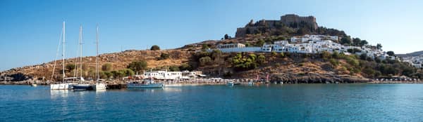
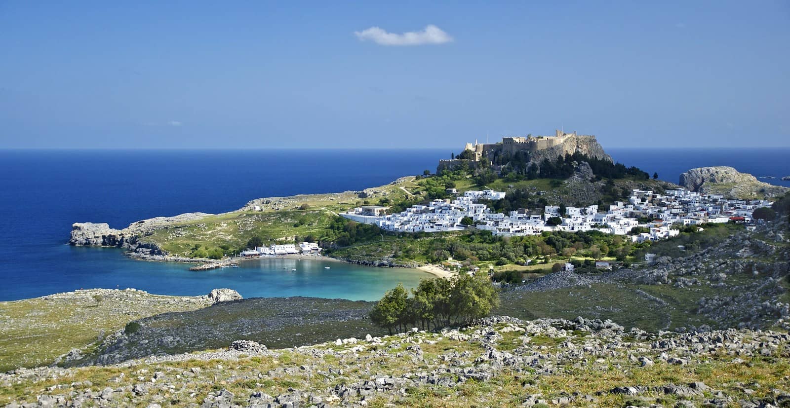
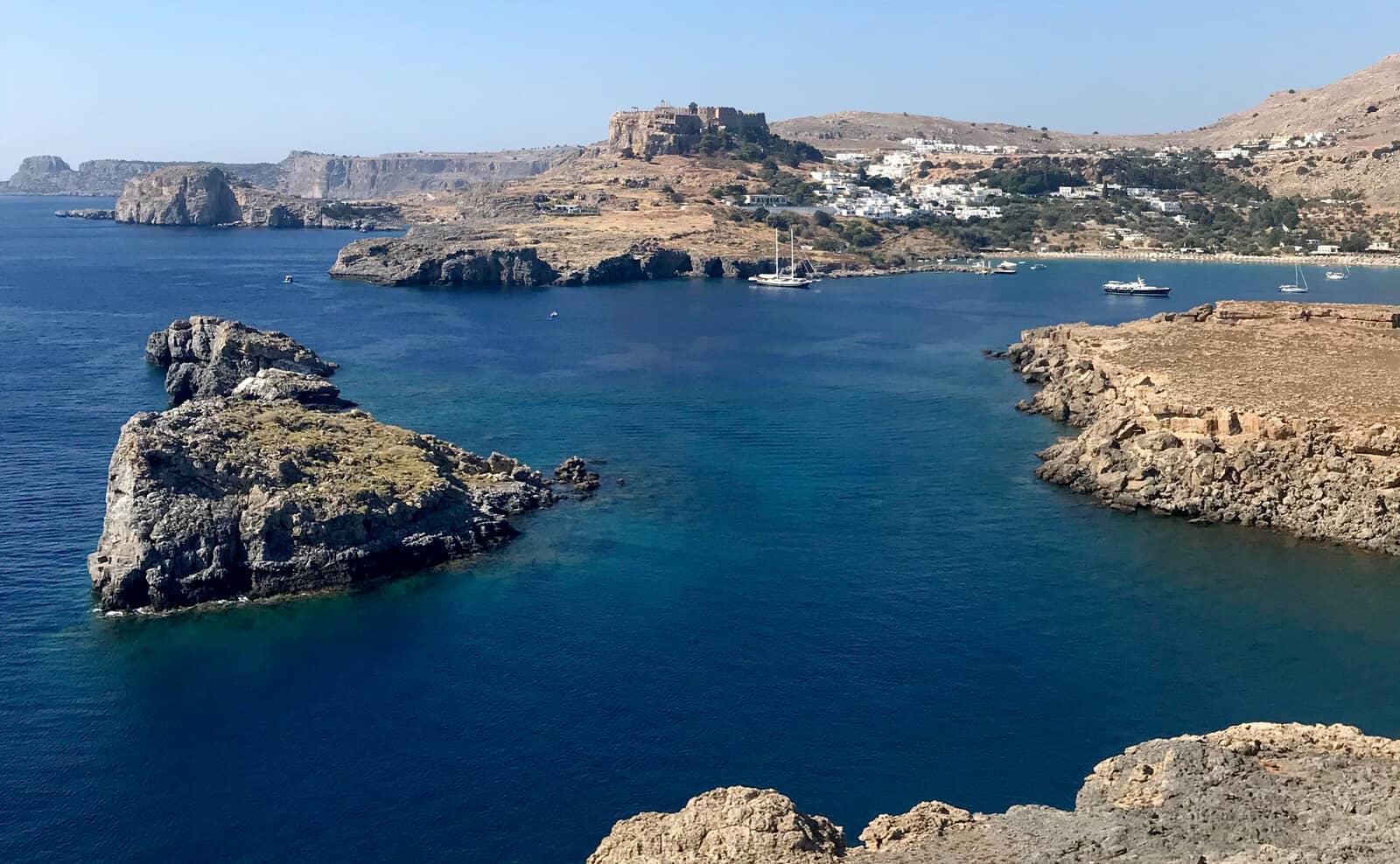
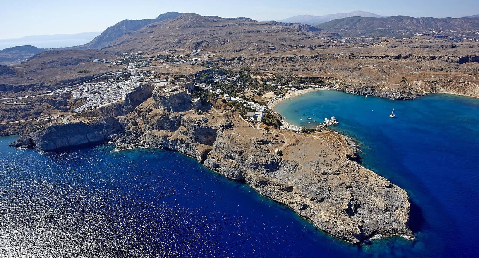
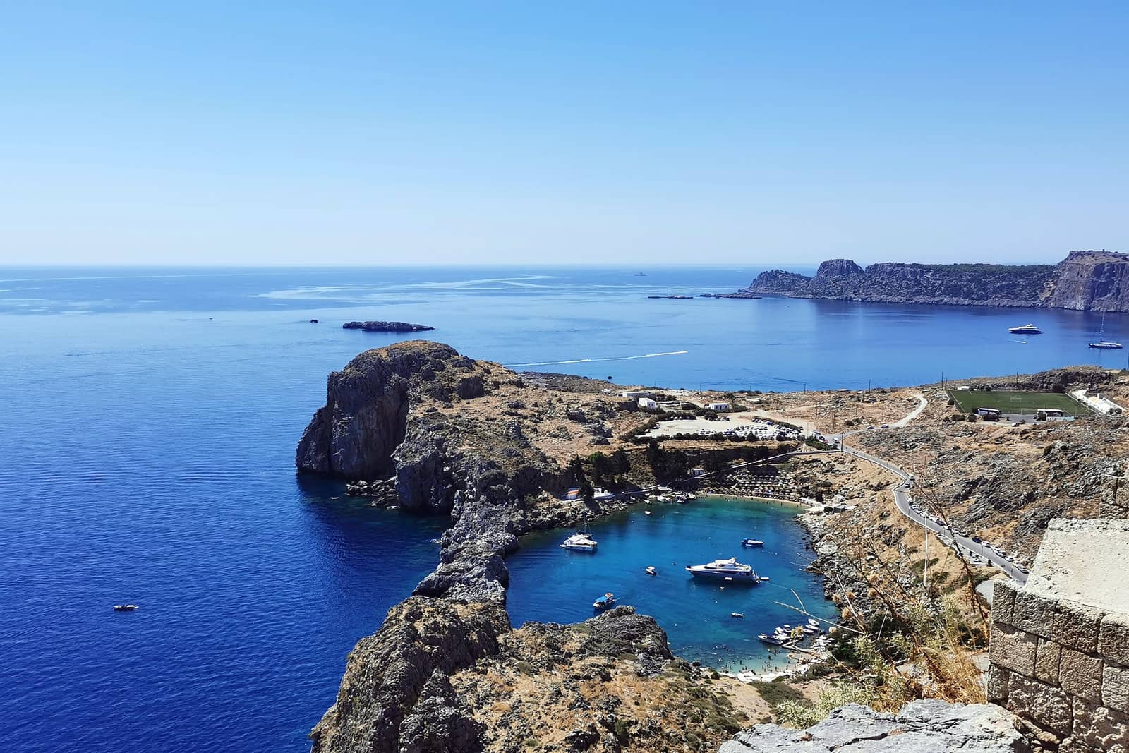
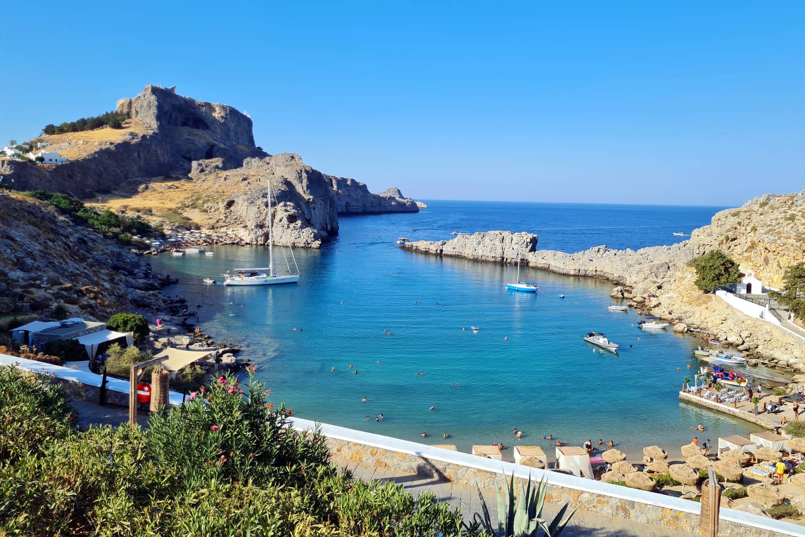
Lindos
Lindos - Λίνδος is dramatically situated on a promontory high over the sea, and is Rhodes' second town, with a year-round population of 800, and was long Rhodes' first town. With its cubed houses wrapped around the fortified acropolis, it has kept its integrity only because the entire town is classified as an archaeological site, unique in Greece.
The town has been inhabited continuously from the 3rd millennium BCE, the powerful fortifications were started by the ancient Greeks, extended by the Byzantines and completed by The Knights.
Register for free and join an active, critical sailing community.
The Lindos peninsula has 4 bays:
- Vlychá - Βλυχά bay – on the north side of Lindos peninsula – is not a popular anchorage Lat Long; good holding in mud; even in NE winds the waves will be small; anchor in 5 – 8 m in mildly attractive surroundings despite several gaudy resorts.
- The actual bay of Líndos - Λίνδος under the citadel Lat Long is one of the highlights of the Dodecanese, with – aside from the pier – 4 options to anchor:
- in between the pier and the NW cliffs Lat Long, just outside the swimming and beach zone in 4 – 8 m.
- in the north cove Lat Long note the shallow patch (<3 m), see C-Map or Garmin, and certainly Eagleray.
- the preferred spots near the NW cliffs Lat Long with a line ashore.
- under the islets in the NE at the entrance Lat Long of Lindos bay.
The whole Lindos bay offers good shelter from SW – NNE winds.
Be sure to try and get a berth at the pier, however these berths are during “tourists hours” reserved for the local caïques and day tripper boats.
Restaurants in the old town: aim for the Village Cafe and Giorgos Food Cocktail Bar, and along the beach at Lindos bay for Panos Restaurant & Bar.
The daily “touristic tide” peaks between 10:00 and 16:30.
- Agios Paulos or St Paulus - Άγιος Παύλος is a tight natural harbour Lat Long; a true delight with plenty of rocks to tie a line to.
The name mentioned in the GWP, “Ág Apostoli”, is inexact; besides:
Ágioi Apóstol(o)i - Άγιοι Απόστολοι refers to the Saint Apostles / Holy Apostles, plural and often all twelve.
In ~43 CE, during a storm, the apostle Paul reportedly landed / shipwrecked here on Rhodes, hence this toponym.
An incessant swell will penetrate in NE – SE winds, otherwise allround shelter.

The white Church of St Paul is on the right.
- Péfki - Πεύκοι – south of the Lindos peninsula Lat Long – either east or west of Cape Gíanouri; unfrequented by yachts yet useful in all but southerlies. The east cove is as underwhelming as the mundane beach on the west side, but offers slighly more protection.
Like on Santorini « donkey cruelty », tourists are urged to avoid riding the donkeys up to the Lindos' acropolis.
During Meltemi the lee side (east) of Rhodes island is subject to severe westerly gusts.
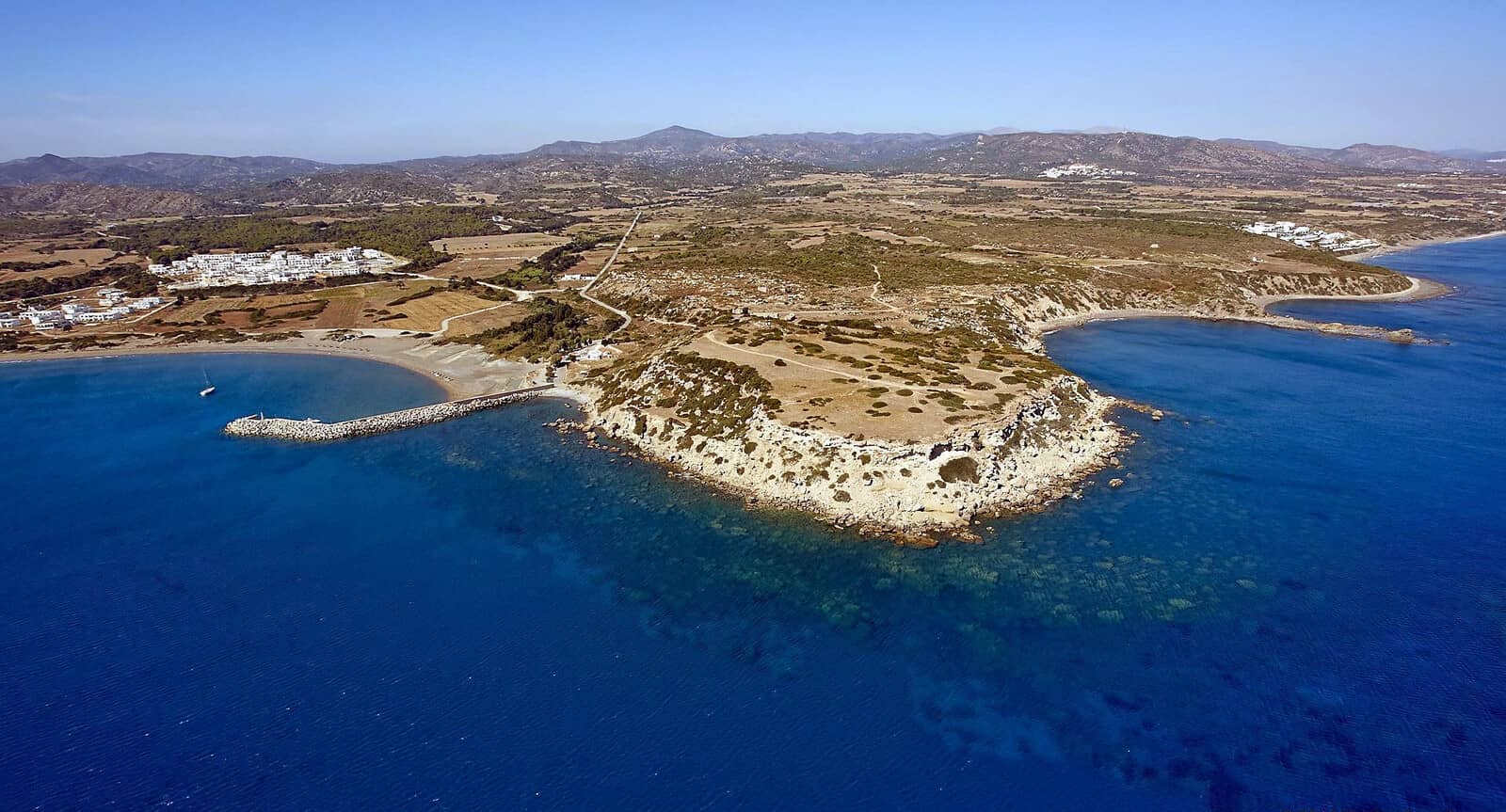
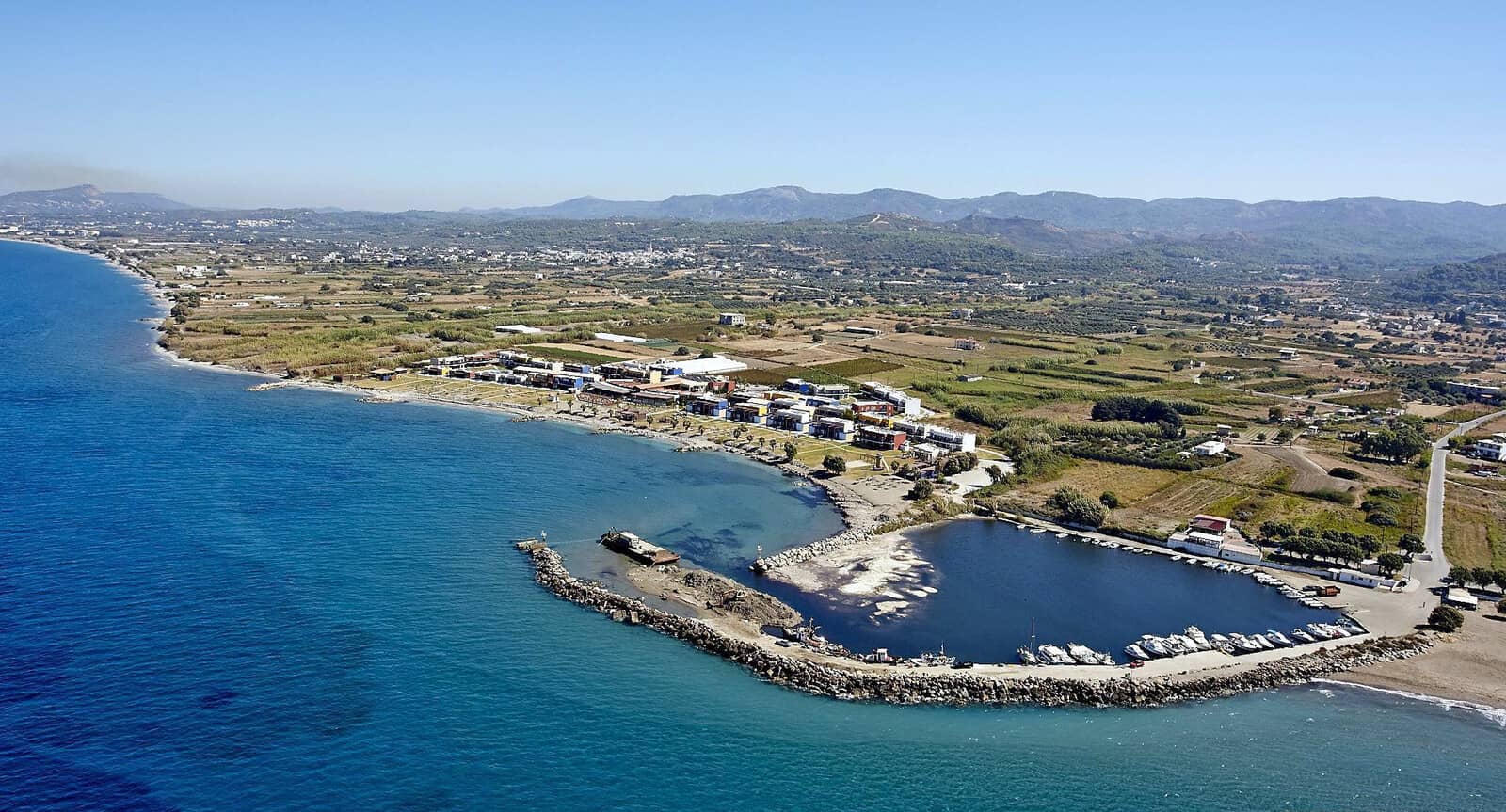
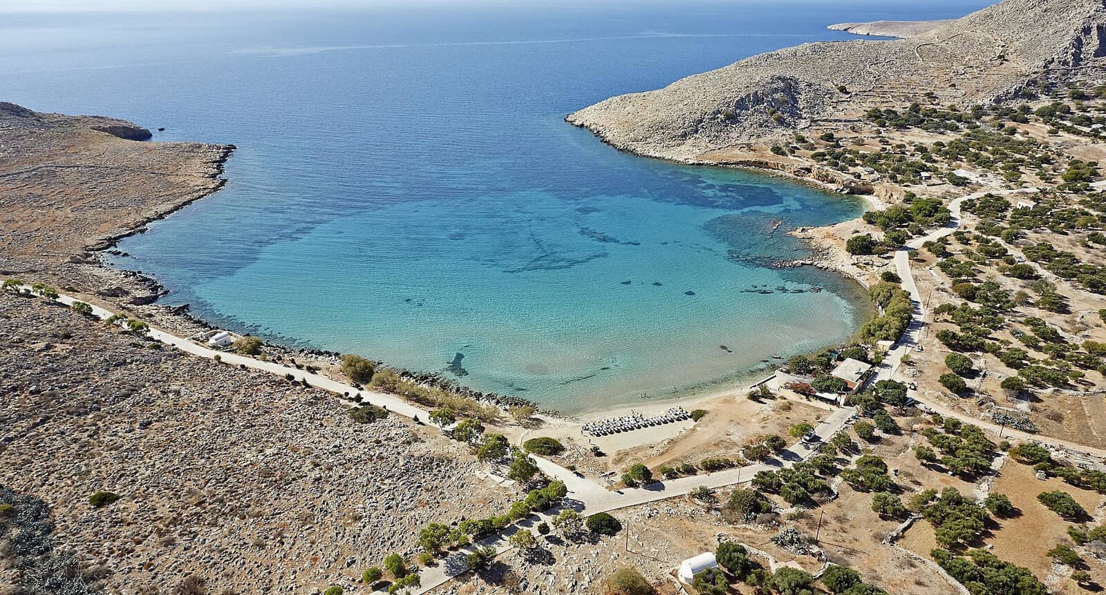
Plimmyri
Plimmýri - Πλημμύρι port under Cape Istros - Ἴστρος
is silted up except for the north facing part of the pier Lat Long, very good holding in pure sand. you will most likely need to anchor in the bay.
See drone photo above.
Fabulous beach, far away from most tourists despite a jet ski, wake boarding, banana, etc. “water sports center” run by a friendly German couple halfway down the beach.
0.45 NM south of the pier an isolated danger buoy marks a shipwreck (wreck diving delight).
Vigli
Further south under the commodious Cape Viglí - Βιγλί is a tantalising anchorage Lat Long with reasonable protection against Meltemi forces with good holding in sand though gusty.
Atypically for Rhodes, this bay offers a relatively pristine beach called St George.
Halfway the narrow cape you will find the ruins of a late-medieval vigla which gives the anchorage its name. Viglas are small medieval cylindrical towers which served as an early warning system against pirates or other invaders.
In SW winds also consider the anchorage on the north side of the Cape.
Prasonisi
Prasonisi - Πρασονήσιον – the southern tip of Rhodes –
is a windswept peninsula, which is illustrated by the nimiety of kite surfing and wind surfing fans and their motor homes.
Ruefully, this cheerful crowd has detrimental effects on the local environment; e.g. the protected Caretta caretta turtle used to hide its eggs in the area.
It is possible to anchor at either side of the sandbar; drop anchor in 3 – 5 m over sand.
The north side provides good shelter from southerlies, whereas the south side is adequate during a Meltemi (NW).
The island itself is surrounded by dangerous reefs.
“Prasonisi” means “green island” and its isthmus will be flooded during winter or Meltemi storms. Water depths are just 10 – 30 cm and since there is no current it perfectly safe to cross. Occasionally the sandbar is breached by a small but deep and potentially dangerous canal and the peninsula becomes an island for the coming months (sometimes years), see Prasonisi floodings [in German].
Note, the isolated and low-lying Nes Chína islet / rocks at 7 NM / 100° from Cape Prasso's Lighthouse.
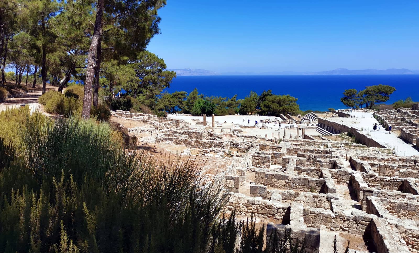
At the top of the hill was the acropolis, with the temple complex of Athena Kameiras and the stoa.
The main settlement was on the middle terrace, consisting of a grid of parallel streets and residential blocks.
On the lower terrace are found a Doric temple, probably to Apollo.
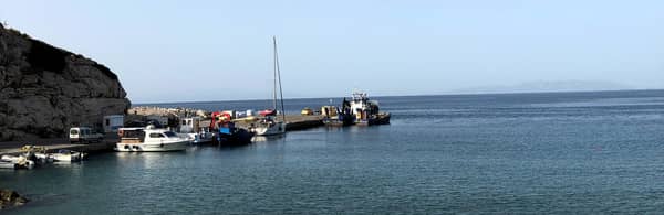
Kameires Skala
Kámeires Skala or Kámiros Skála - Κάμειρος Σκάλα Lat Long is named after the ancient Doric city of Kameirus / Camirus which is oddly enough some distance away and actually closer to Fanes port.
Good shelter from Meltemi; open to the north, but safe in SE – W winds; the ferry to Chalki docks here, ask the fishermen for a berth; quayside is 1,8 m above sea level; anchoring in the bay only advised in southerlies; not a port but just a quayside and the swell becomes quickly uncomfortable.
±300 m west of the port and ±40 m out of the coast is a rock awash.
Fanes
The minute port of Fánes - Φάνες or “Fanai” offers allround shelter but is permanently silted and there is even a weed patch under the northern breakwater Lat Long; a sandbar all but blocks the entrance (sometimes <1 m); contact the fishermen VHF 8 of 10 before entering; good protection against Meltemi once inside, but windy conditions create high waves along the coast and gaining access is even more convoluted; there are plans to significantly enlarge the basin. Works started in 2023, heightening the outer mole, and are not yet finished in 2025 (entrance looks worse now).
The port and its setting are uninspiring, however
Butterfly Valley is a 20 min. taxi ride away; the season for these creatures of the Soul, see Psyche, is June till September.
Must-see are the ruins of the third city of ancient Rhodes: Kameiros / Camirus, a 10 min. drive or 1½ hr walk to the south.
Before the ancient settlement, the area was inhabited by Mycenaeans. The city itself was founded by the Dorians in the eighth century BCE. The earthquake of 226 BCE destroyed the city and the temple. The earthquake of 142 AD destroyed the city for the second time.
Interestingly, Kameires Skala is named after this ancient city; also see “skala”-name.
Trianta
Triánta - Τριάντα also known as Ialyssós - Ιαλυσός is a wide open bay only fit in very light winds Lat Long, preferably from SE – E; anchor in 4 – 8 m on sand, good holding; para-sailing, jet-skis and banana boats.
Despite an alluring lush mountainous backdrop, this anchorage is defaced by the ceaseless chain of seaside resorts.
Further inland is the ancient polis of Ialysus – one of the three ancient Doric cities in the island, and one of the six towns constituting the Doric hexapolis – which is a nice day trip with peacocks as a bonus.
Alimia island
Alimniá - Αλιμνιά or Alimiá - Αλιμιά, named Evlimnia or Eulimnia in ancient times, meaning: “with good harbours” referring to the Alimnias and Imporeios bays.
Not to be confused with Alimia Bay on Irakleia island, Lesser Cyclades.
The ancient castle ruins are from the Hellenistic Period (334 – 30 BCE when the island was a naval station / shipyard of the Rhodian navy), and which partly survived, partly provided material for construction of a medieval castle in 1475, when Rhodes and its surrounding islands were occupied by the Knights Hospitaller. Also for the panoramic views it is worth to climb to the top (269 m, ±50 minutes); bring hiking shoes, long trousers and water.
Semi–, Hemi–, Demi–
The English language has a number of prefixes that come from the concept of “half-” as in “hemisphere”, “semi-permanent”, “demi-god”, but with different meanings.
Why so many, and what’s the difference between them? Read on…
The Italian army built barracks on Alimia during their occupation of the Dodecanese region between 1912 and 1943, and used the area as a submarine base.
In WWII German U-Boote (submarines) and smaller craft used to hide in Alimnas bay for the Allied forces. The Nazi-Armee had plans to install a radio and radar installation and deported the islanders in 1944. In April that year, British Commandos unsuccessfully attacked the island – they were captured and eventually executed.
In the barracks German grafitti in oil pastel display the nostalgia for “die Heimat”, see Alimia German history [in German].
Garmin and Eagleray have the most accurate charts showing the reefs and dangers.
Gusts are NW, and the Meltemi (WNW) is surprisingly gentle around Alimnia island.
In all anchorages: try to take a line ashore • see how to do this.
Alimia is a snorkeling delight with its turquoise waters, and totally off the beaten track.
Anchorages ↺
- Alimniás bay also known as St George bay is the largest indentation of the island and offers 3 suitable & delightful spots; discarded moorings on the seabed, so use a trip line:
- at the beach of Alimnias bay, west of the Church of St George - Άγιος Γεώργιος Lat Long from where you can explore the ruins of the settlement that are clustered around this church.
- near the Church of Ágios Minás - Άγιος Μηνάς Lat Long; what looks like a solid pier here is actually a reef / submerged foundations; there is no longer a floating pontoon; open to SW – NW but in westerlies it is possibly to relocate to Tigani cove at the entrance of Alimnias bay.
- Tigáni - Τηγάνι cove Lat Long with a wreck on the east side (crane visible); allround protection in very pleasant surroundings.
- Teíchos - Τείχος bay has a steeply inclined seabed, deep anchorage Lat Long; NW winds can funnel over the isthmus.
- The bay of Imporeiós - Ιμπορειός Lat Long is sheltered in all but easterlies; stunning views towards Rhodes; Meltemi proof.
- The wide and deep bay of Pelegrinás - Πελεγρινάς Lat Long the name possibly comes, via Medieval Latin pelegrinus, from Classical Latin peregrīnus: Pilgrim; remarkable shelter from Meltemi; sand / weeds and a few stones, good holding.
Chalki island
With its Neoclassical pastel houses overlooking a horseshoe harbour, Chalki or Halki town - Χάλκη is a miniature version of Symi. The island is arid and rocky, and water may run short in summer. Chalki is famous for keeping its old music traditions alive. Tourism is still small-scale; fishing and goat-herding provides most of the income.

Chalki Emporios
The enticing port of Hálki or Chálki - Χάλκη is often called after its seaside settlement: Emporiós - Εμποριό meaning “market”. The winding narrow streets are a delight.
Follow the westbound road to the Medieval Castle, which is located on the hill of St Nicholas over the old settlement Chorió “village” of Halki. It was built by the Knights of St John in the 15th century over the ancient Hellenistic citadel. From there they were able to control the sea routes and the harbour.
Inside the castle are the ruins of the medieval church of St Nicholas. At the gate, the emblem of the 40th Grand Master of the knights Pierre d'Aubusson (1476 – 1503), is engraved. A zealous opponent of the Ottoman Empire, he was responsible for the repairs and modernisation of the defenses of the Dodecanese islands (see first Siege of Rhodes (1480) and Bodrum Castle.
The old village along with the castle is the most important archaeological site on the island. The now ruined medieval village is located on St Nicholas Hill in the shadow of the castle. It used to be the main village on the island and has been lived in permanently since the era of the Knights. It was inhabited until the mid-19th century providing shelter from pirates.
Local winds: easterlies in spring are problematic; bay is safe in SW – N winds, yet
dangerous in ENE – SSE winds; in northerlies, waves can reflect from Nisáki island into the bay; due to significant depths the only anchor option is along the north shore.
You can dive right off your yacht: marvellous swimming conditions in the bay; alternatively you will find swimming stairs along the waterfront; use your holding tanks.
The T-pontoon ( May 2023 and June 2024) has laid moorings only at a few of the ±15 berths, therefore be prepared to drop anchor in 12 – 18 m deep; harbour master Statis +30 6940859419 will guide you; gusts are NW – NNW; pontoon is removed for the winter first week of November, and usually installed again in the second week of May; some debris and old tyres on the seabed near the shore; no electricity but water is free; swell from the ferries and in gales the pontoon shifts a lot from side to side.
The west side is much preferred since less chance of fouling your anchor and better holding.
With ferry connections to Rhodes town, Tilos, Santorini, Crete and even Athens / Piraeus you won't normally get to stay uninterruptedly at the ferry quay on the south side, room for two yachts along-side or more if stern-to.

Although the Turks were initially unable to capture the Knights' castles on Chalki, Rhodes, etc., the islanders were dealt with barbarically: enslaved, raped or burned alive…
The 1522 Treaty was swiftly breached by the Turks, see second Siege of Rhodes (1522), and the atrocities started anew.
Italy seized the Dodecanese from the Ottomans in 1912 and forcibly converted the islanders to Roman Catholicism, prohibited Greek language, schools and even the Cycladic blue colours on houses. Fortunately the Italians were much less cruel than the Turks.
Note, the three conspicuous windmills on the ridge, and Potamos bay far right.
Potamos
The bay of Potamós - Πονταμός bay Lat Long – directly west of Chalki Port – offers an attractive anchorage suitable in all but southerlies; solid safety, also against Meltemi winds; gusts W – NW.
Anchor in 4 – 6 metres in sand, there are (more) rocks are greater depths.
The approach: steer a course of 0° into the bay, there are shallow areas on either side of the entrance.
To avoid the regiment of parasols at the northern beach, there a lovely beach in the NW corner; anchor in 3½ – 4 m.
Nick's Taverna offers (vegetarian / vegan) take-away.
Mini-market closeby in the direction of the port.
Cobalt blue waters that are mostly unfrequented, since (mega)yachts tend to favour anchoring at the exposed Ftenágia beach, south Lat Long of Chalki port.
Note, the various spellings (Póndamos / Pontamos / Potamos), all meaning river or stream; compare Mesopotamia, "Between the Rivers", and hippopotamus, “river horse”, see chart terms.