Mykonos & Delos sailing holidays
The bare rocky island of Mykonos - Μύκονος was once one of the most important trading centres in the western Aegean.
Its arid and only moderately fertile soil permits merely a modest development of agriculture, but its beautiful beaches have made it one of the most desired holiday islands in the Aegean, attracting artists, LGBT+ and more recently the indulgent jet set / nouveau rich
Likewise, the new “marina” port is growing in popularity and is actually becoming a small charter base from which you can hire charter yachts to start your sailing holiday. Moreover, it has a flourishing craft industry and Mykonos is the starting point from which to visit the neighbouring island of Delos, the historical centre of the Cyclades.
Visiting (charter) yachts are not welcome in the old port: use the east basin of the marina.
Rent scooters .
History of Mykonos
According to legend Mykonos was the rock with which Poseidon slew the giants.
The island's history was closely bound up with that of Tinos. Unlike Tinos, however, it was occupied by the Turks, though it contrived to maintain a considerable degree of independence under Turkish rule.
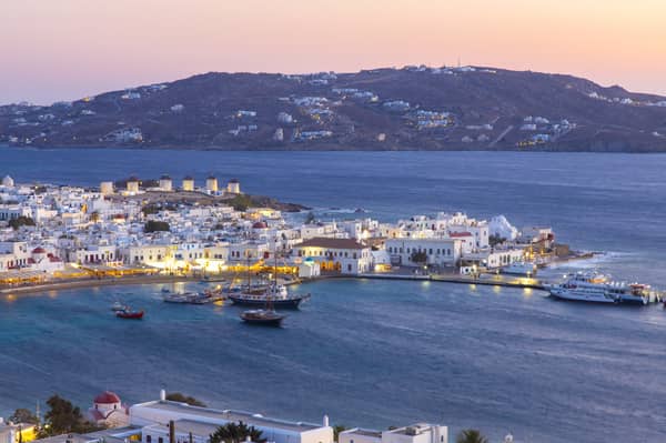
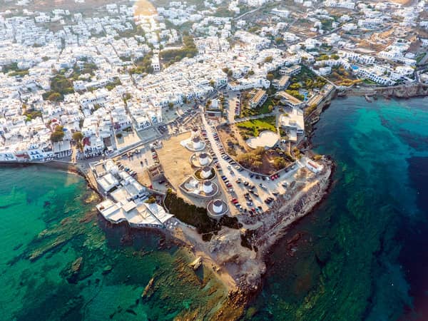
The chief place on the island is Mykonos or Chora, cube-shaped whitewashed houses with numerous churches and the eminent windmills, extending in a semicircle round a bay on the west coast. It occupies the site of the ancient city of the same name.
The local museum features archaeological material from Rineia and Delos. The most interesting of the churches is the Paraportiani Church, which is built on four levels.
East of Mykonos lies the rocky island of Tragonisi or Dragonisi, with sea-caves frequented by seals.
The mascotte of Myconos town for more than 30 years was a tame pelican named Pétros. After his universally lamented death in December 1985 he was stuffed and can now be seen in the museum.
Ports & anchorages
Mykonos island
Clockwise ↻
Delos island
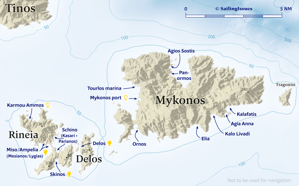
Ports / anchorages are clickable . signifies a highly recommended venue, and a truly must-see venue; see other icons.

Mykonos island
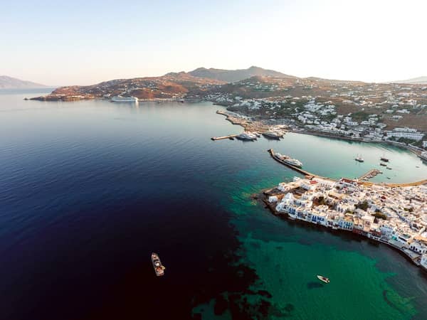
Mykonos port / marina
The graceful port of Mýkonos - Μύκονος is for superyachts & gulets only, and even outside the season you will be sent towards the Tourlos Marina; Harbourmaster (SMS / Text only) 6946 942091.
From this desolate (even more utilitarian than Alimos) but safe “marina” you can rent scooters to explore Mykonos town & island and mingle with an eclectic mix of LGBT+, affluent beau monde, nudists and kitesurfing hippies.
Visit the Archaeological Museum and the Aegean Maritime Museum.
Agios Sostis / Panormos
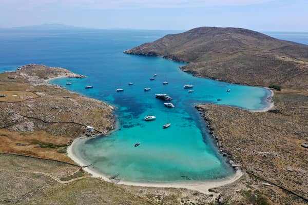
On the north of Mykonos – in a deep inlet in what is commonly seen as Panormos bay – are two coves: Ágios Sóstis - Άγιος Σώστης Lat Long
and actual Panórmos - Όρμος Πανόρμου. Lat Long
Agios Sostis, when close to the bright-white homonymous church, is only vunerable to NE winds and quite picturesque.

then around the double-headed cape the bay of Agia Anna
and to the the left the large bay of Kalo Livadi. Hi-res image
South coast anchorages
Note that C-Map and GWP (completely ) show the wrong locations of Agia Anna, Kalo Livadi, Elia bays, whereas Eagleray, OpenSeaMap and Garmin show the correct situation. From east to west:
- Kalafátis - Καλαφάτης bay Lat Long
has a reef marked by tiny buoys and a pool with a blue flag about 200 m from the beach; ruins on the north section of the bifurcated cape.
“Petrino Aquarius Taverna” on the beach. - Agía Ánna - Αγία Άννα bay Lat Long where you can anchor in 4 – 5 m in sand / weed; archaeological site to the west; rows and rows of beach chairs resemble a disciplined army.
- Kaló Livádi - Καλό Λιβάδι Lat Long bay offers a more gentle anchorage, despite – again – throngs of sunbathing lobsters.
Mind the low lying islet+reefs in the middle of the southern approach. - Eliá - Ελιά Lat Long bay is the most appealing south coast anchorage: turquoise waters with the best shelter (only affected bay SE-SW winds) and least amount of sunbathers. If possible anchor at the Agrari beach (good Taverna) or the cove further west, opposite the tourist dwelling of Elia.
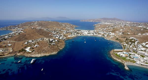
- Ornós - Ορνός bay is exceedingly popular: expect superyachts. The quay is reserved for the privileged, the best anchorage is not at the head of the bay, yet in the SE corner Lat Long.
Mediocre holding in sand / weed; possible fierce gusts from NE.
Vulgar bars and restaurants tend to the needs of the opulent glitterati, hence Mykonos features in this top 3.
Rineia island
The rocky island of Rineia - Ρήνεια lies between Mykonos and Delos and is also known as Megali Dilos, the ancient Reneia. After the second purification it became the burial-place for Delos.
Skinos
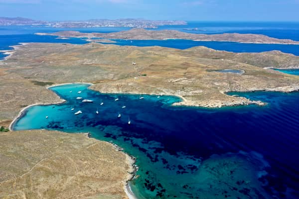
Skínos - Σκίνος alias “South bay” is a deep inlet on the south coast of Rineia Lat Long; excellent holding in sand; good protection against the Meltemi; a well on the west shore; even in mild southerlies you can stay by taking a line to the rocks; best spot is in the NE cove where there is only room for a few yachts to swing at anchor.
See photos below.
Miso /Ampelia
The wide Misó - Μισό or Ampelia - Αμπέλια bay on the west Lat Long with several coves, notably Mesianós / Lygiás - Μεσιανός /Λυγιάς Lat Long is open to W-SSW winds; suitable in Meltemi conditions; reefs along the east shores as well as extending from the capes.
Karmou Ammos
Karmoú Ámmos - Καρμού Άμμος is open to the northerlies; there are several coves to choose from, but the eastern ones are too shallow for larger yachts; archaeological remains on the west side close to the best anchor spot Lat Long.
Schino
Schíno - Σχίνο is the large east bay with several anchorages; in particular Kasari - Κάσαρη Lat Long in the north and Parianós - Παριανός Lat Long in the south. The approaches are hampered by a large number of reefs and rocks. Kasari isn't secluded enough in stronger north or east winds, although very good holding in sand. The – often lee shore – beaches on the south (Parianos e.g.) are sometimes cleaned by plogging yachtspersons.
Even in summer (this photo is taken in June) most yachts and tripper boats will leave in the end of the afternoon providing a truly delightful anchorage.
Delos island
Dílos or Délos - Δήλος likewise is a rocky island and lies 5 NM south-west of Mykonos and it is one of the smallest of the Cyclades.
According to the ancient myth Delos was the birthplace of Apollo and Artemis. The destinies of the island turned on its importance as a pan-Hellenic shrine.
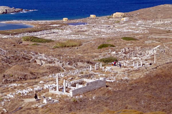
The extensive area of remains excavated under the direction of French archaeologists from 1873 onwards is one of the most important archaeological sites in Greece.
Yacht charters
Mykonos island is itself a minor yacht charter base. The other two starting points are the yacht charter bases of Paros, Parikia port and Athens, Alimos marina.
The earliest settlers on Delos, in the 3rd millennium BCE, were Phoenicians and Carians.
After their displacement by Ionians in the 1st millennium BCE the island became the main centre of the cult of Apollo, and splendid games – said to have been originally established by Theseus – were held annually in honour of the god.
Delos map
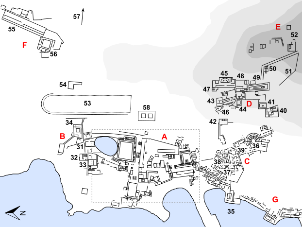
- Area of the Sanctuaries of Apollo and Artemis
- Area of the Sacred Lake
- Area of the Theatre
- Slope of the Mount Cynthus (Kynthos)
- Mount Cynthus (Kynthos)
- Area of the Stadium
- Harbours
- Delian Temple of Apollo
- Athenian Temple of Apollo
- Poros Temple of Apollo
- Colossus of the Naxians
- Temple of Artemis
- Keraton
- Treasuries
- House of the Naxians
- Ekklesiasterion
- Thesmophoreion
- Stoa of the Naxians
- Bouleuterion
- Prytaneion
- Neorion or Bull Monument
- Stoa of Antigonus
- Propylon
- Sacred Road
- Agora of the Delians
- South Stoa
- Stoa of Philippus
- Agora of the Competaliasts
- Agora of Theophrastus
- Hypostyle Hall or Stoa of Poseidon
- Sacred Lake
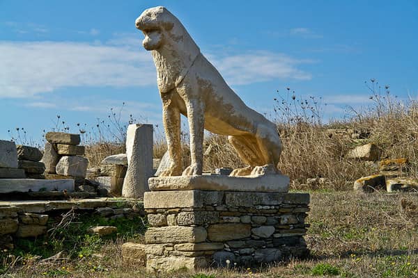
- Lion Terrace
- Temple of Leto
- Temple of Twelve Gods
- Agora of Italians
- Sanctuary of Dionysus or Stoibadeion
- Sacred Harbour
- House of the Lake
- House of Diadumenos
- House of Poseidoniasts
- Granite Palaestra
- Trading Harbour
- Theatre
- House of Kleopatra
- House of Dionysus
- House of Trident
- House of Masks
- House of Dolphins
- House of Hermes
- House of Inopos
- Samothrakeion and Memorial of Mithridates
- Sanctuary of Syrian Gods
- Serapeion A
- Serapeion B
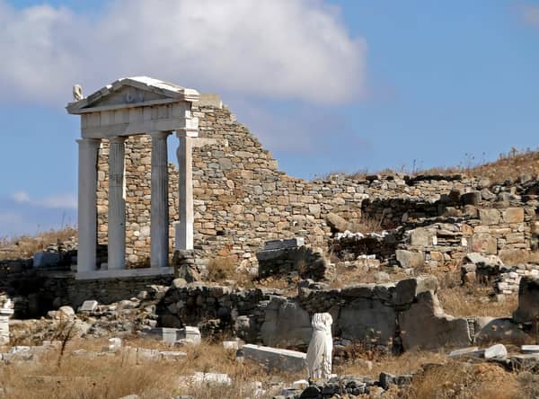
- Serapeion C, including Temple of the Egyptians Gods and Temple of Isis
- Temple of Hera
- Sanctuary of Agathe Tykhe or Philadelpheion
- Cave of Cynthus (Kynthos)
- Cynthian Sanctuary of Zeus and Athena
- Hippodrome
- Archegesion
- Stadium
- Gymnasium
- Synagoga
- (Archaeological Museum) (modern)
Archaic period
Classical period
Hellenistic period
Roman period

In the 6th c. BCE Peisistratos carried out a purification (catharsis) of the island by removing all tombs from the area round the sanctuary, and in a second purification in 426 – 425 BCE all births, deaths and burials on the island were prohibited and the existing tombs were removed to the neighbouring island of Rineia or Rhenea.
When the Panionic League was founded after the Persian Wars, the Temple of Apollo was selected as the treasury of the League.
In 454 BCE, however, Athens carried off the contents of the treasury and reduced Delos and the other islands to a condition of dependence. In 314 BCE Delos asserted its independence of Athens and thereafter developed a prosperous trade which made it the economic centre of the archipelago.
Foreign trading guilds including the Hermaists (Roman) and the Poseidoniasts (Syrians from Berytos, present-day Beirut) established themselves on the island.
In 166 BCE the Romans gained control of Delos, and thereafter assigned it to Athens. This brought a revival of the island's prosperity, particularly after the destruction of Corinth.
The end came with the devastation of Delos by Mithridates in 88 BCE, followed by its complete destruction by pirates in 69 BCE. Thereafter the island was almost uninhabited, and when Pausanias visited it in the 2nd c. he saw only the custodians of the deserted sanctuary.
A fresh settlement was established in Christian times, but this was only a brief life.
Dilos port & regulations
In accordance of Rule 14 of the special Rules of Mykonos harbour:
- Disembarkation of persons is forbidden from any vessel in Delos island as well as the approach (passage, stay, anchorage), closer than 500 m.
- Vessels where crew/passengers wish to visit the island may approach and anchor in its harbour ONLY during the hours for which the archaeological site is open (paragraph 3). That is daily except Monday, from 08:00 – 15:00 hours. It is also closed on 1 January, 25 March, Good Friday, Easter Sunday – Monday, 1 May, 25 – 26 December.
- Applications for vessels to approach for special reasons, in restricted areas and hours, will be examined by the Harbour Office at Mykonos (paragraph 3).
Despite the strict regulations we have seen several yachts spending the night anchored in the channel between Delos and Reneia (S or SE of Rematia in northerlies and NW of Rematia in southerlies).
Furthermore, several visitors of my website have told me that yachts are condoned, even permitted, to visit Delos and enter Delos port when the exhibitions close.
Locals say that the Fournos / Fourni Bay, 500 m further south Lat Long, is the best anchorage (there are traces of an ancient harbour there). For spending the night, the island of Rineia will provide even better shelter from the Meltemi, which funnels into the narrow and shallow Delos channel with steep waves.
To avoid any offence and observe the 500 m rule, we've indeed used Skinos bay on Rineia after 15:00, while anchoring south of Rematia Lat Long for the actual visit, using the dinghy to approach Delos port.
