Aegina sailing holidays
Aegina - Αίγινα, lying some 17 NM south-west of Athens, is a hilly and fertile island of Tertiary limestones and schists, with isolated rounded hills of volcanic origin. For the most part the coast falls steeply down to the sea, with few sheltered bays.
The main occupation of the inhabitants is farming, in particular the growing and export of the island's excellent pistachio nuts. Fishing, sponge-diving and pottery manufacture are also of some economic importance. Aegina is noted for the production of its water-coolers (kannatia) – two-handled wide-necked jars in a porous fabric which keep their contents cool by evaporation.

- All Greek islands
- Argolic – Saronic overview
- Argolic gulf
- Spetses island
- Hydra gulf
- Poros island
- Aegina island
- Saronic gulf – Athens
- Alimos – Athens
- Sailing itineraries Argolic & Saronic gulfs
With its mild climate and low rainfall, Aegina has long been favoured as a summer resort by the prosperous citizens of Athens. In recent years it has become increasingly popular with foreign visitors.
Ports & anchorages
Ports / anchorages are clickable .
British Admiralty Chart 1657. signifies a highly recommended venue, and a truly must-see venue; see other icons.
History of Aegina
The legendary ancestor of the Aeginetans was Aiakos / Aeacus, son of Zeus and the nymph Aegina and father of Peleus and Telamon, who was celebrated for his wise and just rule and became judge in the Underworld together with Minos and Rhadamanthys.
The earliest traces of Pelasgian settlement on the island date from the 3rd millennium BCE, see section on the pelasgians.
In the 2nd millennium Aegina was already an important trading-station, dealing in pottery and ointments, as finds of Helladic, Cycladic and Minoan material have shown.
It is first recorded in history as a colony of the Dorian city of Epidavros / Epidauros, and together with Epidavros was ruled in the 7th c. BCE by Pheidon of Argos.
After shaking off the control of the its mother city in the 6th c BCE. Aegina enjoyed a period of some prosperity, which soon brought it into competition with Corinth. The Aeginetans had trading posts in Umbria, on the Black Sea and in Egypt, and their ship owners were the wealthiest in the Ancient World. Aeginetan coins bearing the effigy of a tortoise are the oldest known, and by 656 BCE already had a wide circulation, and Aeginetan weights and measures remained current into Roman times.
Potato in Greece
When Kapodistrias – first Governor of Greece – offered potatoes to Greek farmers to remedy post-war famine in 1829, the farmers were not ready for such novelty, so he had to resort to a trick, more…At the beginning of the Persian Wars this seafaring State was at the height of its power. After the Battle of Salamis, in which 30 vessels of Aegina took part, an Aeginetan ship was awarded the prize for the highest valour. But Aegina was also led by its commercial interests to offer Darius' envoys earth and water in token of submission, whereupon, on the motion of Athens, it was called to account by Sparta. This was the occasion of further conflicts with Athens, which saw the strong neighbouring island as an obstacle to the expansion of its sea-power. After naval victories at Angistri and off Aegina itself the Athenians – though simultaneously fighting with Megara and in Egypt – forced Aegina to submit after a nine-month-long siege, and in 456 BCE the city was compelled to pull down its walls, surrender its warships and pay tribute to Athens.
When the Peloponnesian War (431 BCE) started, the Aeginetans were expelled from their island and the land was distributed to citizens of Attica. After the final defeat of Athens in 404 BCE many of them returned, but the island's great days were over. Athens rapidly recovered and after a series of military campaigns regained control of Aegina, which thereafter shared the fortunes of the Athenian State.
From 12 January to 3 October 1828 Aegina was capital of Greece.
The island is named after the nymph “Aígina”, daughter of god Asopós, and is the place to where she was abducted by Zeus while he forced his love on her.
Donate now
Aegina town and port
The chief place on the island, Aegina (pop. 9000), lies on gently rising ground on a wide bay at the north end of the west coast.
It occupies the site of the ancient city, Egina, which was larger than the present town. From the harbour, sheltered by a breakwater, there are fine views of the smaller islands of Metopi and Angistri to the south-west and Moni to the south and of the hills round Epidavros.
The Archaeological Museum contains material from the temples of Aphaia and Aphrodite, together with pottery and other grave-goods ranging in date from the 3rd millennium BCE to Roman times.
Kolona
On the hill of Kolona, to the north of the town, is an 8 m high Doric column. According to Pausanias this belonged to the temple of Aphrodite by the harbour (460 BCE): in fact the temple was dedicated to Apollo. Under the temple were found remains of Mycenaean and pre-Mycenaean settlement (3rd millennium BCE). To the west were two smaller temples, probably dedicated to Artemis and Dionysos. A sphinx (circa 460 BCE) which was discovered here in 1904 is now in the Archaeological Museum.
Ancient harbour
Below the temple, to the south, was the ancient commercial harbour, now silted up. When the sea is calm the old quays can still be seen under water. The modern harbour, on the site of the ancient naval harbour, is still protected by the ancient moles which have been maintained in good condition. On the north mole, the longer of the two, is and early 19th c. chapel dedicated to St Nicholas.
Register for free and join an active, critical sailing community.
Tomb of Phokos
1½ km north of the town is a mound (6th c. BCE) similar to the “Soros” at Marathon, traditionally identified as the Tomb of Phokos, who was killed by his half-brothers Peleus and Telamon.
Temple and Sanctuary of Aphaia
The road to the Temple of Aphaia , 13 km east of Aegina town, runs through rolling country, partly wooded and partly cultivated, passing the Church of Ayii Theodori (1289, frescoes), built of stones from ancient temples. In 8 km it reaches Palaiochora, the medieval capital of the island, which was abandoned about 1800. Above the village, which has some 20 chapels ranging in date between 13th and 18th c., is a ruined medieval castle.
Farther on, the road passes the scattered houses of the village of Mesargos, soon afterwards a steep footpath leads up to the temple.
The Temple of Aphaia (5th c. BCE), a goddess associated with Artemis as a protectress of women (foundation inscription; terracotta decoration), is built on the foundations of a 6th c. temple, which itself succeeded a pre-Greek cult site. It is peripteral in type, with 6 × 12 columns. The pronaos and opisthodomos were enclosed by antae, between which were two columns.
See my Greek architecture page for more classical terminology.
The roof of the cella was borne on two rowns of columns. In the opisthodomos is a stone altar-table. The temple preserves 23 columns of yellowish limestone, with fragments of their stucco facing – particularly at the east and along the sides – some of the columns are monolithic.
The roof and the sculptural decoration were of Pentelic marble. Unusual features are irregularities in the floor of the cella and the subdivision of the opisthodomos. In the floor are holes for fixing a grille.
The sculpture in the pediments was looted by the Crown Prince Ludwig of Bavaria – much like Lord Elgin & the Parthenon – and is now in the Glyptothek in Munich. Other sculpture from the temple can be seen in Athens and Aigina museums.

At the east end of the temple, extending across its whole width and connected with it by a ramp, was a sacrificial altar. To the south of the ramp was a small propylon with octagonal columns. The sacred precinct had been banked up to form a level surface and was supported partly on the natural rock and partly on retaining walls of dressed stone.
In the surrounding area the remains of Late Neolithic houses (4th – 3rd millennium BCE) were found by the excavators. From the temple there is a superb view, covering most of the Saronic Gulf and extending to the coast of the mainland, from Athens to Cape Sounion.
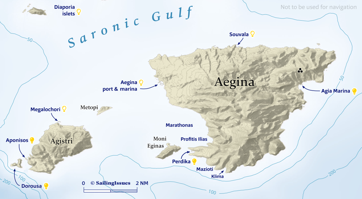
Aegina island
Souvala port
The mini harbour of Souvala - Σουβάλα on the north coast is often overlooked, Lat Long. The usable part (3 – 4 m deep) of the mole is just a few boat lengths long, go alongside or bows-to / stern-to near the red light. Good shelter except for strong northerlies; good holding, sandy bottom; a plentitude of pleasant tavernas line the beach.
The port's name is derived from Slavic “suvala” meaning “swamp”, likely pointing to the use of cisterns (moist retainers) and not to marshland, since Aegina was much more desiccated in earlier times, see the old open cisterns (souvalas) and water supply of Aegina.
Notably, Souvala served as the capital as well as the main port of the island till 1826, which is demonstrated by its proximity to the historic gems of Aphaia, Paleochora and the Monastery.
In fact, Souvala provides the nearest access – a 1 hr hike through a semi-wooded landscape – to Paleochora, the now deserted “old town” where the islanders avoided pirates by having transformed their medieval village into a fortress in the 9th c. CE.
Slightly further is the Monastery of St Nektarios - Μονή Αγίου Νεκταρίου, the area remained deserted after the famous pirate and admiral Barbarossa killed all the men and sold 6 thousand females and children into slavery in 1537.

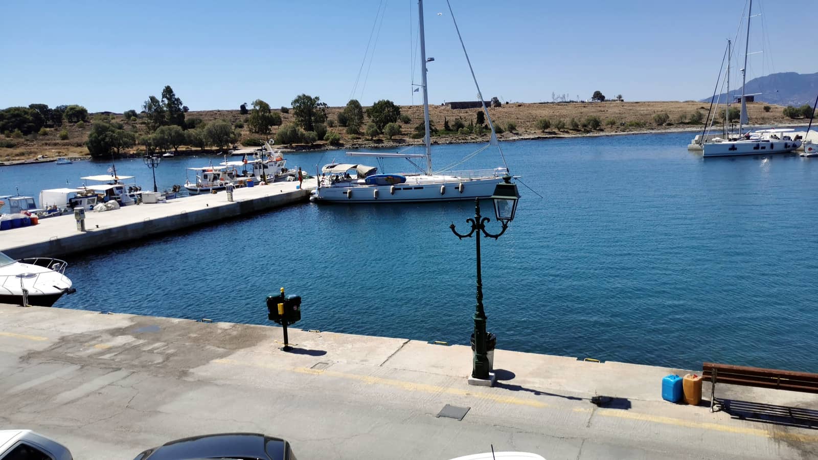
Aegina harbour & marina
Ask the harbour office for a berth inside the traditional harbour; VHF 12, 19. Certainly in the sailing season there is no room in the marina (filled with local yachts; permanent moorings) and charter yachts will be turned away. Make sure that your anchor holds well, poor holding, mud.
Aegina is overcrowded, even more so in and around the weekends when it can be an inimical place with shouting (local) boat owners and crossed anchors. Once safely docked it can be a very charming town.

The approach of Aegina is fringed with mostly artificial! reefs, a defence line purposely created by ancient Aiginites. Moreover, the natural reefs extending from Agistri and Metopi are also dangerous.
Visit the Archaeological site of Kolona site just north of the harbour.
There is a bus line from Aegina town to the Sanctuary of Aphaia and Palaiochora.
Cape Agios Sozon promontory to the right with – in the middle – the handy short mole for southern winds.
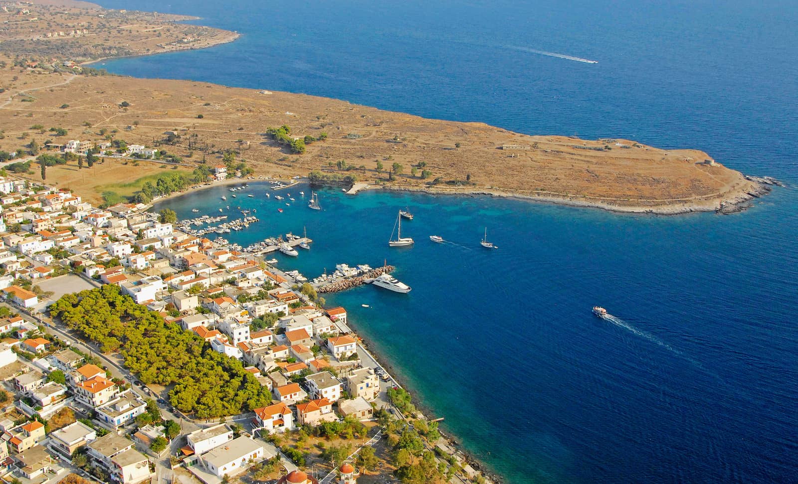
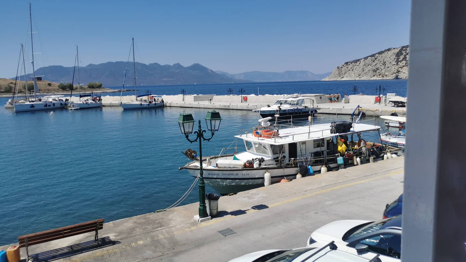
Perdika port
The port of Perdika - Πέρδικα is safe in nearly all conditions except for strong Sirocco SE or ESE winds which result in waves reflecting of Moni islet into the port. Moreover, in strong westerlies only use the leeward sides of the piers. Poor holding in places; the central pier has rocks extending on the west side; crowded in summer, so arrive early!
In southerly winds up to 25 knots you can anchor and take a long line ashore to the short mole Lat Long opposite Perdika.
The NW pier has been extended and fully refurbished , see below.

|
Perdika is an aesthetic fishing village; good tavernas ashore: “Alkioni” and “Anthonis Fish Restaurant”; starting point for a hike to Mt Oros the most prominent feature in the Saronic Gulf (534 m), with scooters you will get half-way to the top, a further 20 minutes walk to enjoy the ecstatic panoramic views over the Gulf.
Take a taxi (or scooter) to the Temple of Aphaia.
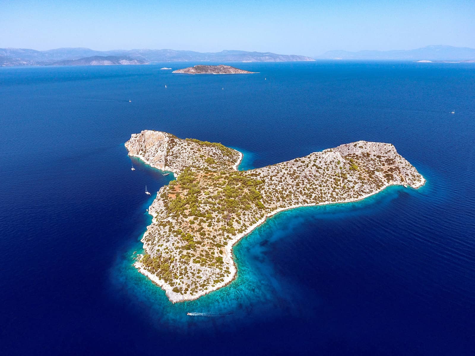
To the west of Pérdika is the small islet of Moní that belongs to a monastery, offering several anchorages on its north coast, and one on the south. Despite the lovely hiking trails it is uninhabited and has been designated a Park and a protected area since 1962, with semi-wild peacocks, deer, goats, pheasants and squirrels.
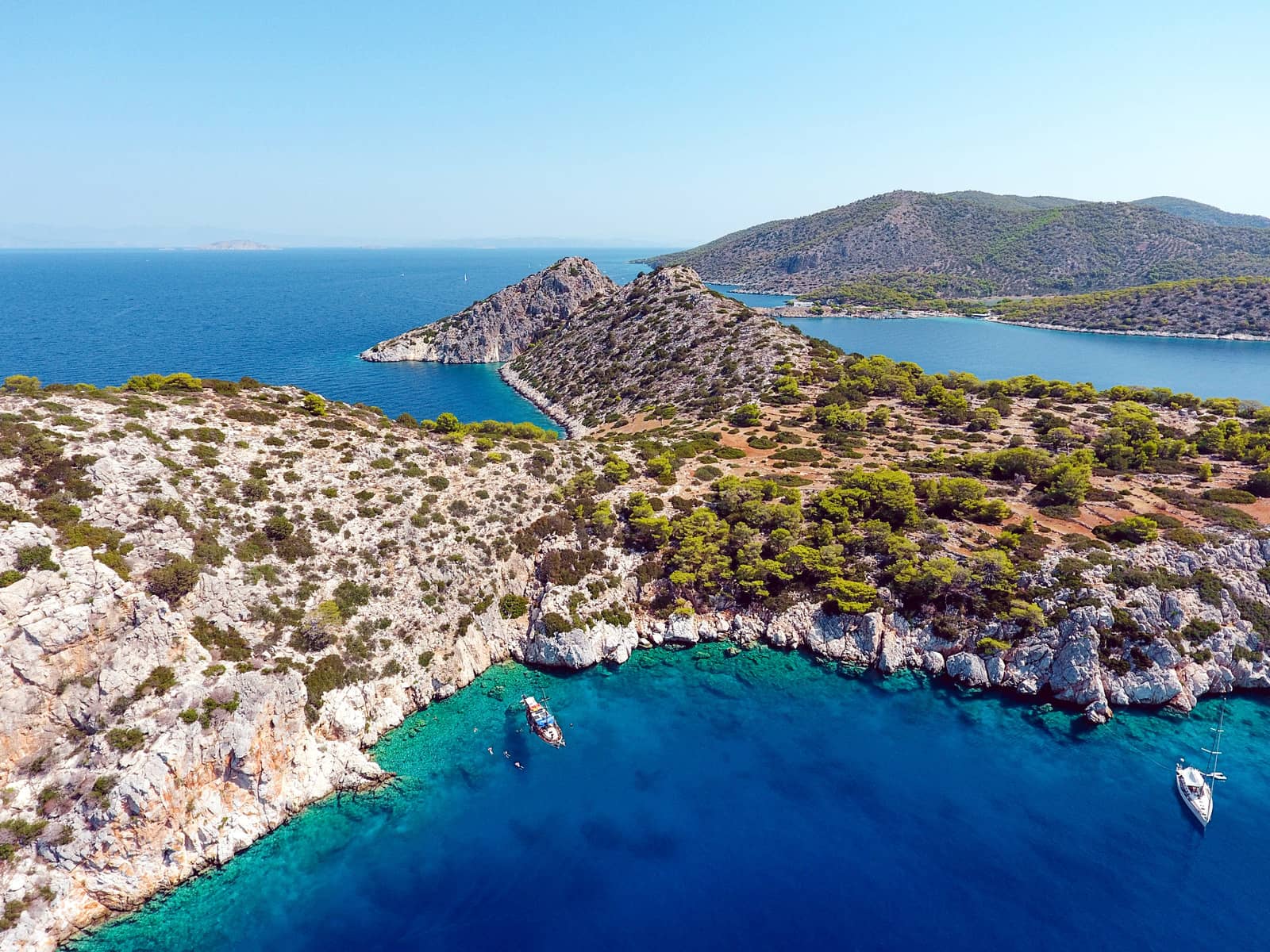
Pyrgos / South coast anchorages
The two bays directly west of Cape Pyrgos are open to NW – SE winds.
- The lively bay of Klima; canteen (summer months) at the superb beach; swimming area marked with buoys; snorkeling, Lat Long. The nearby southernmost settlement of Sfentoúri – that started out as a winter shelter for shepherds – has zero points of interest.
- Mazioti bay; less yachts than in Klima; good holding once anchor is dug in sand; (Meltemi) gusts will come from the east; take a long line ashore to the east shore below the snaking road, Lat Long.
From here it is a splendid walk to the Temple of Aphaia.
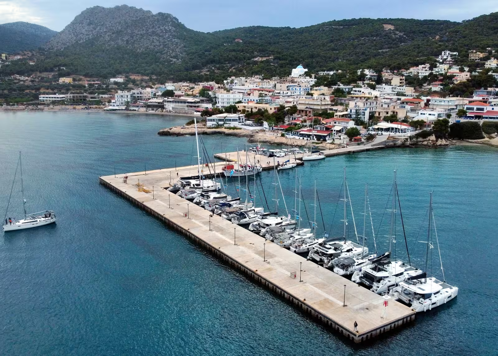
Ayia Marina
The busy little modern resort and half open bay of Ayia Marina on the east coast of Aegina is conveniently near the Sanctuary of Aphaia, a lovely 30 min. walk. The name doesn't refer to a marina port, rather to the martyr Margaret the Virgin (of Antioch).
The in 2021 reinforced quay in the south of the bay is still too shallow, rather use the L-shaped mole in the north and go along-side or stern-to, Lat Long, excellent shelter except for strong easterly winds; prevailing winds in the afternoon are south-east; cruise ships bring heaps of passengers ashore; outstanding tavernas: “Ouzeri Akrogiali” at the beach and Taverna “I Thalassa” at the dock, but also plenty of tourist traps.
The extension of the hammerhead was finally finished in 2023, now an L-shaped mole. Room for ±20 vessels depending on how many catamarans.
However, in March 2025 there is still no power and water, yet the friendly harbour master collects fees. Expect 40+ visiting yachts in the weekends, and double so in the summer months, all vying for those coveted berths on the inside.
Agistri island
Verdant with turquoise waters: 3 NM south-west of Aegina is the wooded island of Angistri or Agistri - Αγκίστρι with a population of 1142, the descendants of Albanians who settled here in the 16th c.
A hilly island with a peak (295 m) on the east side near the port of Skala - Σκάλα, which at first glance might seem the main port, but is too shallow for modern (charter) yachts and catamarans. The Skala beach, however, is pure bliss and pure sand (no pebbles).
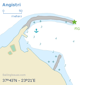
Megalochori port
The only appropriate port is Megalochori - Μεγαλοχώρι, which offers excellent shelter except from strong NE – SE winds (but the SE winds are very rare). Go stern-to the breakwater or mole, or alongside at the pontoon. The south facing stretch of breakwater is home to the local fishing fleet and the extremity [green light] is reserved for ferries, which is vividly indicated. Sometimes the south pier can be used, but mind the water taxis. The approach and the port itself are shallow, but you can see the seabed clearly; sandy with patches of weed.
Aponisos islet & coves
On the west coast of Agistri is Aponisi (Aponisos) - Απόνησσος with especially to the north several beautiful anchorages; pine trees and cerulean waters Lat Long, plus the two coves further NE.
In northerlies you can anchor south of the islet. The mini fishing port of Apolimani is too shallow; the fine taverna near Apolimani is open circa May – October and has a pier (temporary mooring option only for fuel, dining…), stunning views toward Dorousa Lat Long.
All these anchorages combined mean allround shelter.
The “apo-” prefix means "of, from, away from; separate”, see “apogee”, from the navigation course.
Dorousa isle
Directly to the west – across a deep channel with Agistri / Aponisi – is the stunning isle of Dorousa - Δορούσα with an abundance of superb anchor opportunities, notably Lat Long and Lat Long.
Also see gallery 2.
Further reading
See chart symbols for the meaning of e.g. ![]() and the Greek chart terms.
and the Greek chart terms.