Hydra sailing holidays
The Hydra gulf lies between the saronic gulf and the argolic gulf and is a one of the most popular yacht charter areas in Greece.
The island of Hydra - Ύδρα (ancient Hydraea) itself is a bare monolithic ridge of limestone, 12 km long by 5 km wide, lying off the south-east coast of the Argolid.
Arid and infertile, it lives mainly from the tourist trade and the sale of craft products (jewellery, pottery, embroidery, hand-woven cloth, leather-work). A tempting local speciality is the almond cake called amygdalote.
- All Greek islands
- Argolic – Saronic overview
- Argolic gulf
- Spetses island
- Hydra gulf
- Poros island
- Aegina island
- Saronic gulf – Athens
- Alimos – Athens
- Sailing itineraries Argolic & Saronic gulfs
North-west of Hydra is the little grazing island of Dokos (the ancient Aperopia), with the village of the same name in a sheltered bay on the north coast.
The mainland (in fact the Peloponnese peninsula) features many interesting anchorages and the handsome village of Ermioni.
British Admiralty Chart 1031
History of Hydra
Hydra was already settled in Mycenaean times, but was a place of no importance until the 18th c. In the 15th c. and again in 1770, after the revolt in the Morea, Albanian refugees made their home on the island, and as a result of their efforts – in trade and shipping, but also in piracy – it became prosperous and wealthy. During the War of Greek Independence the Hydriots converted their trading vessels into warships and met a large proportion of the cost of the war. The island has now reverted to its original unimportance.
Ports & anchorages
Hydra island
Counterclockwise ↺
Hydra gulf
Hydra gulf • Hydra island chart

Ports / anchorages are clickable . signifies a highly recommended venue,
and a truly must-see venue; see other icons.
Hydra island
Hydra port
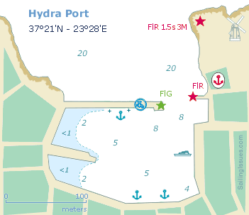
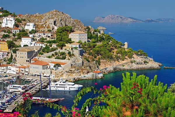
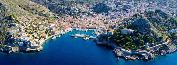
The little town of Hydra (pop. 2500), climbs picturesquely up the slopes of the hills round its sheltered harbour on the north coast of the island. It is now a favourite resort, particularly painters, and intellectuals, who give the town its particular aspect and atmosphere.
On the quay is the 17th c. Conventual Church of the Panayia (Cathedral of the Assumption) with a beautiful cloister and art collection. On the other side of the harbour are the imposing mansions of early 19th c. ship owners and merchants, including the houses of Admiral Lakovos Tombazis (now occupied by an outstation of the Athens Academy of Art) and Dimitrios Voulgaris. One such mansion houses a training school for the merchant navy.
The plain white and sometimes colour-washed houses of the town on the slopes above the harbour are rather Cycladic in type. Above the town to the west are the ruins of a medieval castle, and lower down are fortifications built during the War of Independence.
The Hydra harbour can get quite crowded in the summer months, ten ferries a day plus the odd cruise ship anchored off make it a very tight squeeze altogether. Moreover, anchors are often fouled by other anchor chains and holding is in some places very poor.
See my guide to Mediterranean mooring and anchoring.
The best tavernas can be found further up in town.
There is a lovely restaurant — following the seashore west from the port, walking distance — in the next fishing mini harbour of Kameni.
Kameni
On the doorstep of Hydra port is the shallow harbour of Kameni / Kaminia - Καμίνια (for small fishing boats) where in southerlies you can drop anchor in 6 – 8 m waters outside the west pier and take a line to it. Superb taverna ashore: Kodylenias Resto / Hydra Kodylenia, Lat Long.
Molos
Usually, if Hydra port is just too cramped for comfort, the bay of Molos - Μώλος is an excellent alternative even in most northerly winds, in strong NNW winds opt for Bali.
Molos means “jetty” in Greek, see Greek chart terms, and there are several outside the bay. The approach is difficult from the west: islets, rock formations and reefs; pebbled beach and pine trees; good holding,
Lat Long.
See chart symbols for the meaning of e.g. ![]()
Bali
On the north-west of Hydra island – often overlooked, and “hidden” behind Petasi islet - Πετάσι is the minute cove of Bali - Μπαλή with allround shelter in sandy bottom and good holding.
Even in WSW winds it is a suprisingly secluded spot although NE and SW winds can bring in a swell (see the difference between “seas” and “swells”); use Garmin and Eagleray; room for 2 à 3 yachts; completely beachgoer-free ; anchor in 3 – 6 m and place the second anchor onto the rocks Lat Long.
Agios Georgios
The bay of Agios Georgios - Άγιος Γεώργιος is very popular – expect a number of “tupperware” and motor yachts – since this is the beach and anchorage with the most foliage and where the forest touches the shores.
Sunbathers can arrive by tripperboat only, but tend to focus to the beach and buoyed off swimming area to the north of the headland with the white Ag Georgios Church.
Solid holding in sand; merely affected by SW winds and sufficiently sheltered by Petasi islet; plenty of options to take a line ashore (see how) south of the Church, Lat Long.
Pareidolia
This “delusion of the senses” makes people interpret random images, or patterns of light and shadow, as faces.
Find out what the connection is between Pareidolia and an Epiphany, read on…
Kavouri / Bisti
The pleasant cove of Kavouri or Bisti - Μπίστι on the west tip of Hydra island is exposed to N – E winds; good holding; swell can make it uncomfortable; mildly touristy in season; a forest of pine trees; snorkeling in turquoise waters near the reef, Lat Long.
Agios Nikolaos
The perfect bay of Nikolaos - Άγιος Νικόλαος on the south-west tip is the stepping stone towards Leonidio, Kyparissi, Ieraka (Yerakas) or even Monemvasia.
The ashes of my father were dispersed at the Ayios Nikolaos islet – a decade later I brought my mother's ashes here and they were reunited again.
Glorious sunsets behind the stretch of little islands that guards this cherished anchorage. Drop anchor in 4 – 8 m and drag the stern anchor onto the nearest rocks; open to the SW, Lat Long.
Limioniza
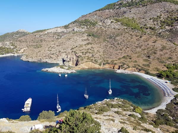
The bay of Limioniza - Λιμνιώνιζα on the south of Hydra island is a lovely beach and marvellously deserted.
In strong NE winds mind the violent gusts down the mountains when sailing along the south coast,
Lat Long.
Mandraki
The bay of Mandraki - Μανδράκι was in earlier times the naval port of Hydra, and two castles on either cape would shield the entrance with canons; one castle is still conspicuous; sandy beach (instead of pebbles); pretentious and distasteful beach resort and ditto tourists; moderate holding; susceptible to swell, Lat Long.

Hydra gulf (Argolis, Peloponnese)
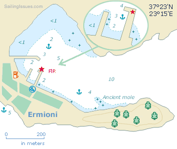
Ermioni port
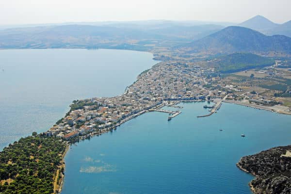
The friendly village of Ermioni (Hermioni) is located at the stem of a wooded headland. Despite its proximity to Athens the place is relatively tranquil and unspoiled from tourists.
Plans to create the “Ermioni 'super-yacht' Marina” in the shallow North corner of the bay have been delayed for years. On land, near the football ground, the area is only fenced off and there is still no activity in August 2022.
The new deadline is end of 2024; accommodating around 127 yachts, up to 65 m in length, bars, restaurants and shops, a swimming pool and chandlery: clearly aiming for the higher plutocratic echelons. Nearby in Porto Heli are the second homes (palaces) of the former King of Greece, the current King of the Netherlands, Roman Abramovic, President Putin, etc.
In earlier times Ermioni was of some importance as shown by the ancient mole and walls near the end of the headland. You can either anchor near this ancient mole or go stern-to or bows-to behind the outer mole. Go to the south side of the headland for more peace and quiet and wonderful vistas across the Hydra Gulf.
Dokos island
The island of Dokos - Δοκός and surrounding waters are an archaeological park, and before 2017 it was prohibited to enter the bay of Skindos / Skintos - Σκίντος.
Most yachts will moor near the taverna and Ayios Nikolaos Church, whereas the small coves on either side of the entrance offer much more sereneness. The west cove is called “Derrick's Bay” (use a tripline to avoid the large chain on the seabed ), and at the opposite cove an ancient wreck was found, my preferred spot.
In 1821, during the War of Greek Independence, Skintos was the winter anchorage of the Hydra fleet. Older history can be found on the brow of the hill (288 m): a Mycenaean wall and dozens of houses, Early Hellenistic walls, but also Byzantine churches and strongholds were built here. The world's oldest 2700 – 2200 BCE wreck is the “Dokos shipwreck”.
Soupia
There is a lovely anchorage behind Soupia – known as “Lizard island” since it resembles a crouching frog, iguana or lizard, when seen from the east. Lovely surroundings with tamarisk trees on the beach providing shade (also for a few peacocks, the bird associated with Hera).
Ideally anchor in one of the two coves, but anywhere north of the island will do; some litter on the seabed (fridge etc.); solid holding in sand, Lat Long.
Tselevinia islets
When sailing from Poros into the Hydra Gulf (or vice versa), mind the hydrofoils emerging from the strait of Skylli at great speed, see day and night signs.
There is a delightful anchorage snug behind Gali islet, east of Spathi island; nothing ashore except a Church; allround shelter; good holding; no wash from commercial shipping, Lat Long.
The south-west bay of Skylli island is open to the south; mind the reefs,
Lat Long.
Collectively these isles are named the Tselevinia islets.
