Lefkas sailing holidays
Lefkas - Λευκάδα - Lefkada (ancient Leukas; Italian Santa Maura) is a hilly island marked by karstic action, lying off the Acarnania region of Mainland Greece, from which it is separated by a shallow lagoon varying in width between 600 m and 5 km. It is now linked with the mainland by a causeway and a pontoon bridge.
Most of the island is occupied by a range of hills rising to a height of 1158 m in Mount Stavrotas and running south-west to end at Cape Doukato, at the tip of the Lefkas peninsula.
It was from the nearby “Sappho's Leap” rock of gleaming white limestone that Sappho of Lesbos was supposed to have thrown herself for love of the handsome Phaon.
This western coast is principally lined with sheer, bright-coloured & white rock faces reaching a height of 500 m, giving the island its name: from the Ancient Greek λευκός (leukós, “white”), compare leucocytes, “white blood cells”.
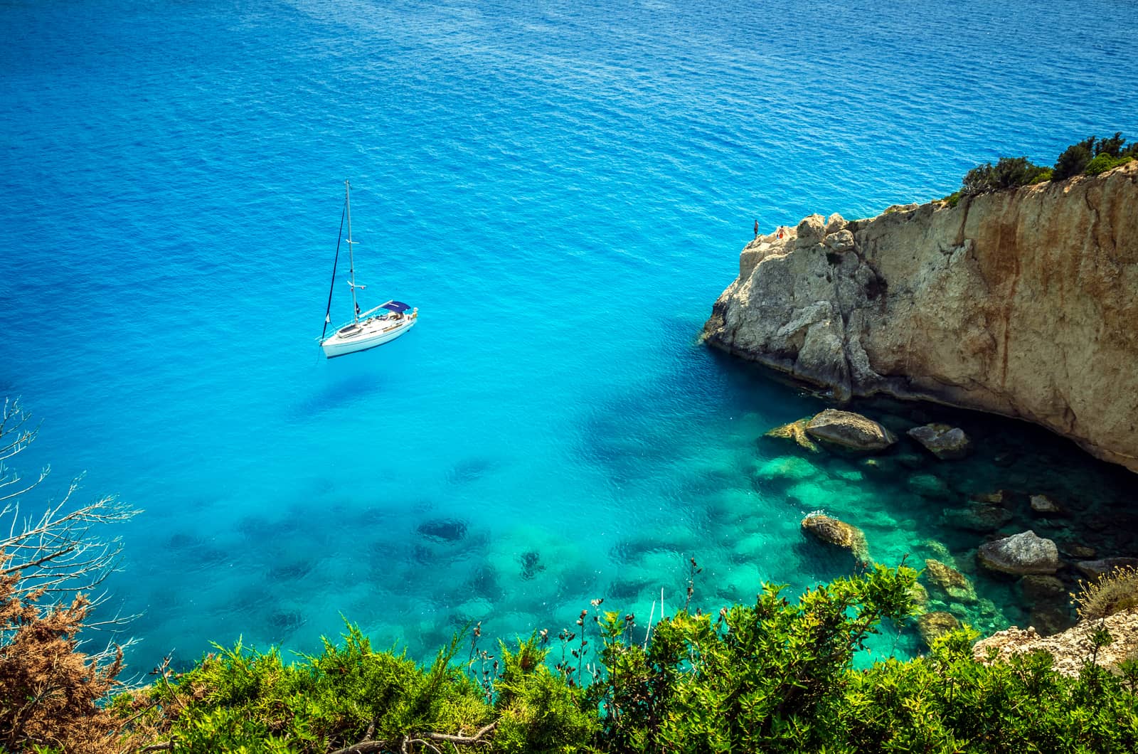
These precipitous cliffs provide an impressive backdrop for several sandy beaches that are among the most beautiful on the Ionian Islands.
The southern and eastern coastlines are richly indented. Many small coves and off-shore islands make for a picturesque view and offer yachtspersons ideal conditions for sailing holidays.
Lefkas never had any permanent natural connection with the mainland. The shingle spit at the northern tip was pierced in ancient times by the Corinthians in the 7th c. BCE to provide a channel for shipping, and, like the spit to the south of Lefkas town, which came into being in the Middle Ages as a result of the establishment of salt-pans, allowed vessels of some size to pass through.
Peninsula
From Latin: paeninsula combining paene “almost” and insula “island”; a landform surrounded by water while being connected to a mainland, read on for the Greek equivalent…
The main sources of income of the inhabitants – aside from tourism – are farming on the island's thin soil, fishing, the recovery of salt from the lagoon and various crafts, particularly lace and knitwear.
Mythology and history
The earliest evidence of human settlement on the island dates from the neolithic period.
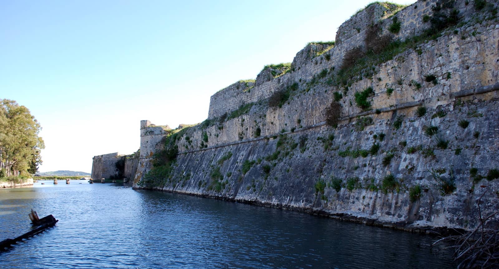
In the 7th c. BCE the town of Leukas was founded by the settlers from Corinth, who closed off the south end of the lagoon, opposite the fort of Ágios Geórgios (Saint George), by a 600 m long mole, remains of which are still visible under water. They cut a canal through the spit of shingle at the north end of the lagoon, opposite the fort of Agía Mavra (Santa Maura) – though by the time of the Peloponnesian War, in which Leukas was allied with Sparta, this prototypal “Lefkas canal” (or “Lefkas channel”) had silted up.
In the time of the Achaean League Leukas was the capital of Acarnania. It supported Phillip II of Macedon against Rome, but was conquered in 197 BCE by the Romans, who later built a bridge linking Leukas to the mainland.
In the Middle Ages the island belonged to the Barons of Cephalonia and Zante and other Frankish dynasts.
In 1479 it was taken by the Ottomans – the only one of the Ionian islands to fall into Ottoman hands – but was recovered to Venice by Morosini in 1684.
After a brief interlude of French rule during the Napoleonic wars it was assigned in 1815 to Britain, which returned it to Greece, together with the other Ionian islands, in 1864.
Register for free and join an active, critical sailing community.
As a result of the vicissitudes of its history and of a series of earthquakes, in particular the 1953 Ionian earthquake Lefkas has preserved very few old buildings, and whereas the other islands opted to rebuild in the traditional style, Lefkas town is a mix of modern mayhem, yet with typical wooden architectural features designed to withstand earthquakes.
Wilhelm Dörpfeld
The German archaeologist Wilhelm Dörpfeld (1853 – 1940), who worked on Lefkas and made his home here, believed that this island, and not the one now called Ithaca, was the Homeric Ithaca, the home of Odysseus.
He based his theory mainly on topographical similarities between Lefkas and the Ithaca described in the “Odyssey”, but this was contested by other archaeologists, and Dörpfeld's excavations failed to produce convincing evidence in support of this theory.
Not as famous as his collegues Heinrich Schliemann, Arthur Evans or Frank Calvert, Dörpfeld's fundamental idea that locations mentioned in Homer's writings correspond to real places is now accepted.
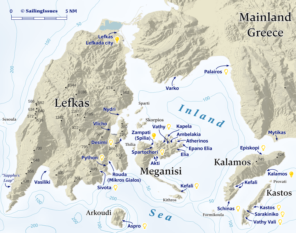
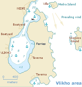
The “Inland Sea”: ports / anchorages are clickable .
British Admiralty Chart 203. signifies a highly recommended venue, and a truly must-see venue; see other icons.
Lefkas island
Vasiliki
Vasilikí - Βασιλική bay is one of the best windsurfing spots due to the strong mistral (NW) wind, which the surfdudes rebaptized as “Eric”. This also means dangerous gusts can occur, much like in the Kalamos strait, at Atokos island and the east coast of Ithaca. Greek terms / names: Vasiliki means “Royal”.

The port of Vasiliki at the head of the bay has been massively extended, yet the pontoons are blocked by buoys and cannot be used, thus wasting €18½ million in European subsidies.
You will still find plenty of safe berths in the inner basin, although the new breakwaters still allow some swell to penetrate.
To request a berth (likely in the old harbour, i.e. inner basin) contact Stathis Vasilatos +30 697 445 80 24.
From here ferries transport tourists to Porto Katsiki beach on the west coast of Lefkas, Fiskardo on Kefalonia and Frikes on Ithaca.
Enjoy the “Yacht Cafe Bar” – facing the inner port – and the affordable “Batzanakias · The Tavern Of The Village” at the west side of the beach. In the past we found Vasiliki rather lacklustre… but with the filled old port the place has become pleasantly vibrant (update April 2024 and October 2025).

Sivota
The Homeric town of Sívota - Σύβοτα – not to be confused with Syvota on the mainland – is set in charming verdant surroundings.
There are frequent strong gusts from the NW – NE, so instead of anchoring, ideally go stern-to the quays or pontoons.
The pontoons are operated quid pro quo by the adjoining tavernas. Try to dock at the pontoon of the “12 Gods Taverna”, the best dining in town, call +30 26450 31880 to reserve a berth.
The west quay area – certainly if there are flotilla fleets – can be quite clangorous, and a more agreeable spot (at a price) is in the north-east corner: the Yacht Bar pontoon, Tel. +30 6946 670 716 or +30 6979 617 718.
Undeniably, this community thrives on the visiting yachts.
Rouda / Mikros Gialos
To the north-east of Sivota is the bay of Roúda / Mikrós Gialós - Ρούδα / Μικρός Γιαλός which offer anchorages in more bucolic settings, although also here: strong gusts are possible; plenty of room for 5+ yachts swinging at anchor. In stable weather you can anchor very close the NW part of the beach near the rocks.
The lovely Python cove is on the other side of the fishing port Lat Long; anchor in the deep and drag the second anchor onto the beach; mind a plastic pipe near the surface near the beach. In the winter of 2026 the building on the beach developed into a bit of an eyesore; room for just one yacht.
The Mikros Gialos port will usually be full with fishing boats. Moreover, anchoring is prohibited within 45 m of the quay , so only go stern-to with maximum scope. Otherwise anchor further west and take a line to the breakwater. The hamlet has some lovely tavernas, notably: “O Molos”.
Vlicho
Vlichó - Βλυχό village consists of a long long stretch of houses under a steep hill, relatively serene so close to Nydri and Lefkas town. It is the ludicrous amount of yachts that rather disturbes the ambience.
The quay – at least outside the holiday months – will offer plenty of opportunities; good holding, yet use as much scope as possible; opt for a berth closer to the L-shaped pier, elsewhere insufficient depths for larger monohulls.
The berths on the pontoons and L-shaped pier are usually reserved: private / local fleet of charter yachts / Vlicho YC.
Most yachts prefer to anchor in the bay, and in peak season it is swarming. Since this large bay is an uninspiring impasse, best to steer clear altogether.
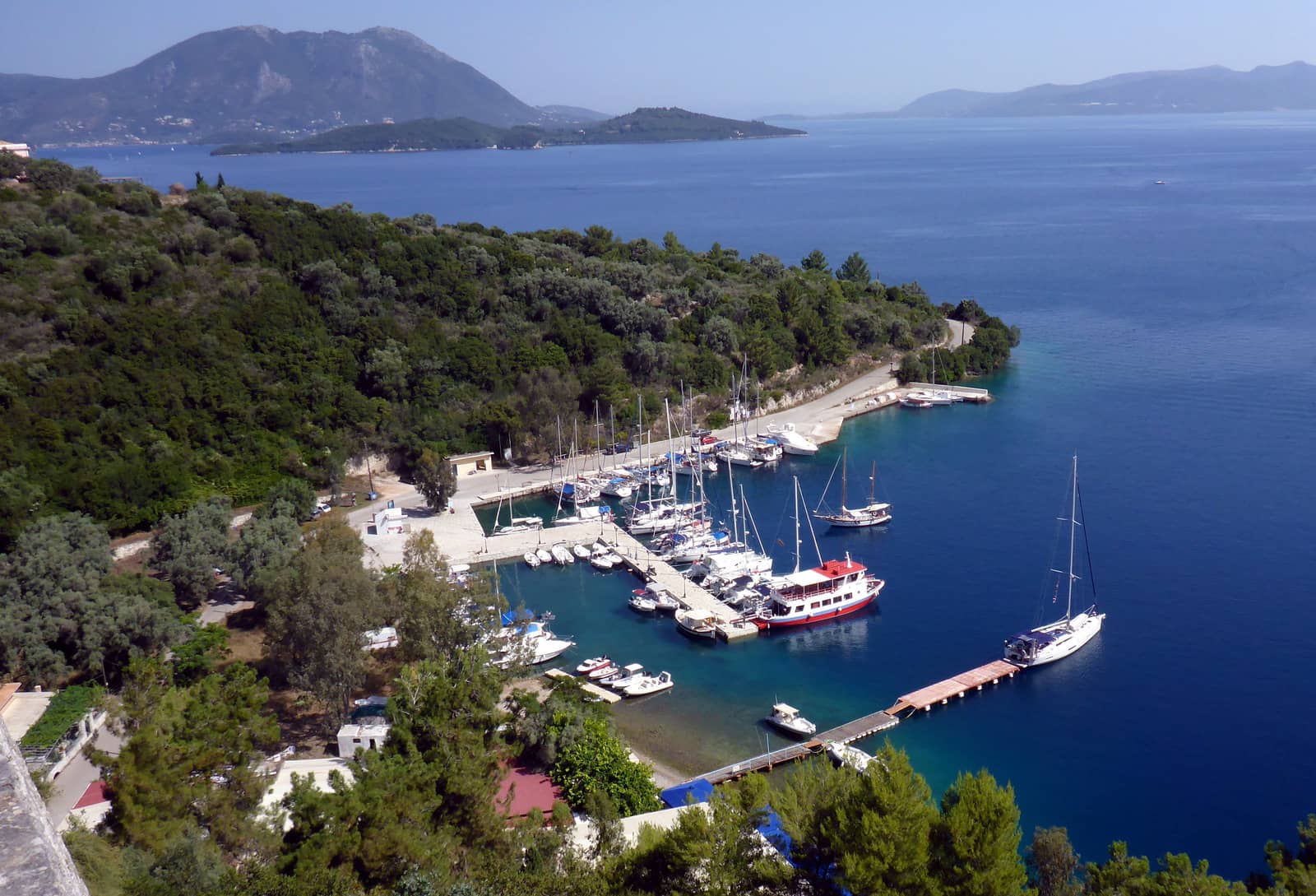
Desimi · Desimou cove
Desími - Δεσίμι, located on the outside of Vlicho bay, is a preferential alternative and also considerably more attractive.
Dine at the Kantina / Καντίνα Lat Long anchor in 4 – 10 m (the bay is therefore not “very deep” as the GWP states).
On the east side, near the cape, is a tiny cove – conspicious white cliffs and minute sandy beach – where you can take a line ashore.

Nydri
The touristy village of Nidrí or Nydrí - Νυδρί lies at the entrance of Vlicho bay. Many sailing holidays start from this bustling little port.
The port (for the most part: quay) is only affected by easterlies and southerlies over 5 Bft; good holding in mud / weed, though use plenty of chain. Also keep the yacht well clear of the quay (or the outside pier of the fishing port) to allow for the wash of passing vessels and truly indifferent tripper boats & ferries.
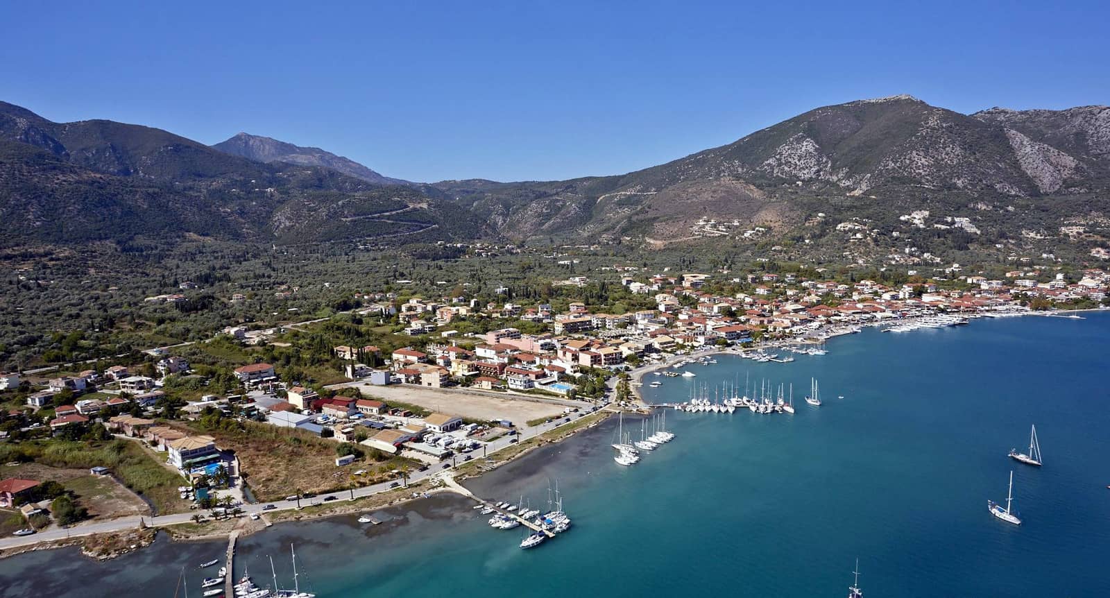
The 5+ pontoons mostly belong the various yacht charter companies operating out of Nidri; aim for Vlicho Yacht Club or Limanaki Taverna (and have dinner there +30 2645 095052). On weekdays you can negotiate a berth with the charter fleet owners, e.g. Sail2day.
Their charter yachts are rotated on Sundays for the strong contigent of British sailors in these waters (matching their flights to / from the UK) and sometimes on Saturdays for other nationalities.
New pontoons, intended for visiting yachts, are planned north of the fishing basin.
Other good spots to consider:
- on the southernmost pontoon (Iris Hotel and yacht charter fleet), you can use the swimming pool, showers etc of the hotel; amiable staff, +30 26 45 09 25 46.
- the outside of the fishing port
- on the quay just south of the northernmost pontoon
Tranquil bay – half a mile to the east – is usually so overcrowded that the anchorage should be called by its actual name: Liaditis bay
Avoid the tourist-trap-tavernas along the waterfront , recommended are “George's place”, “Bardis Tavern” and “Anna Maria Restaurant”.
To cool down, bring bathing suits to swim at the stunning Nidri Waterfalls, pleasant walk 3½ km inland; we saw big snakes though…
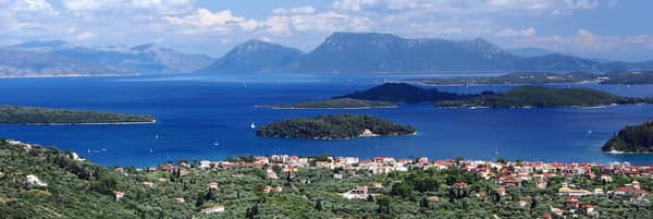
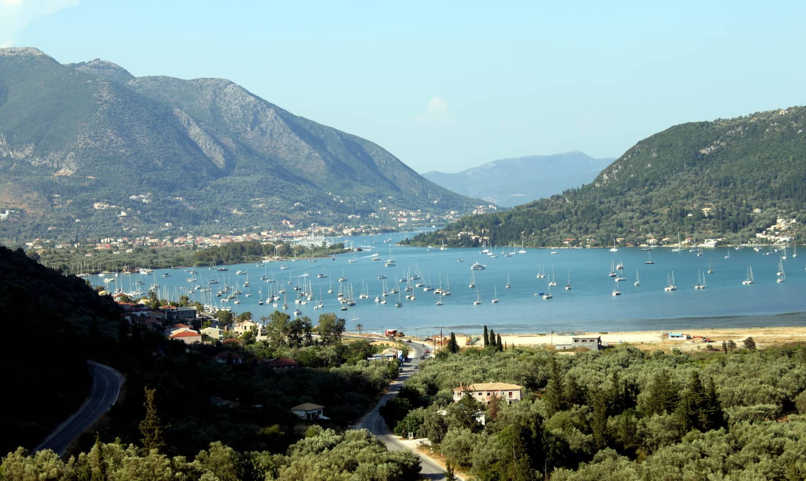
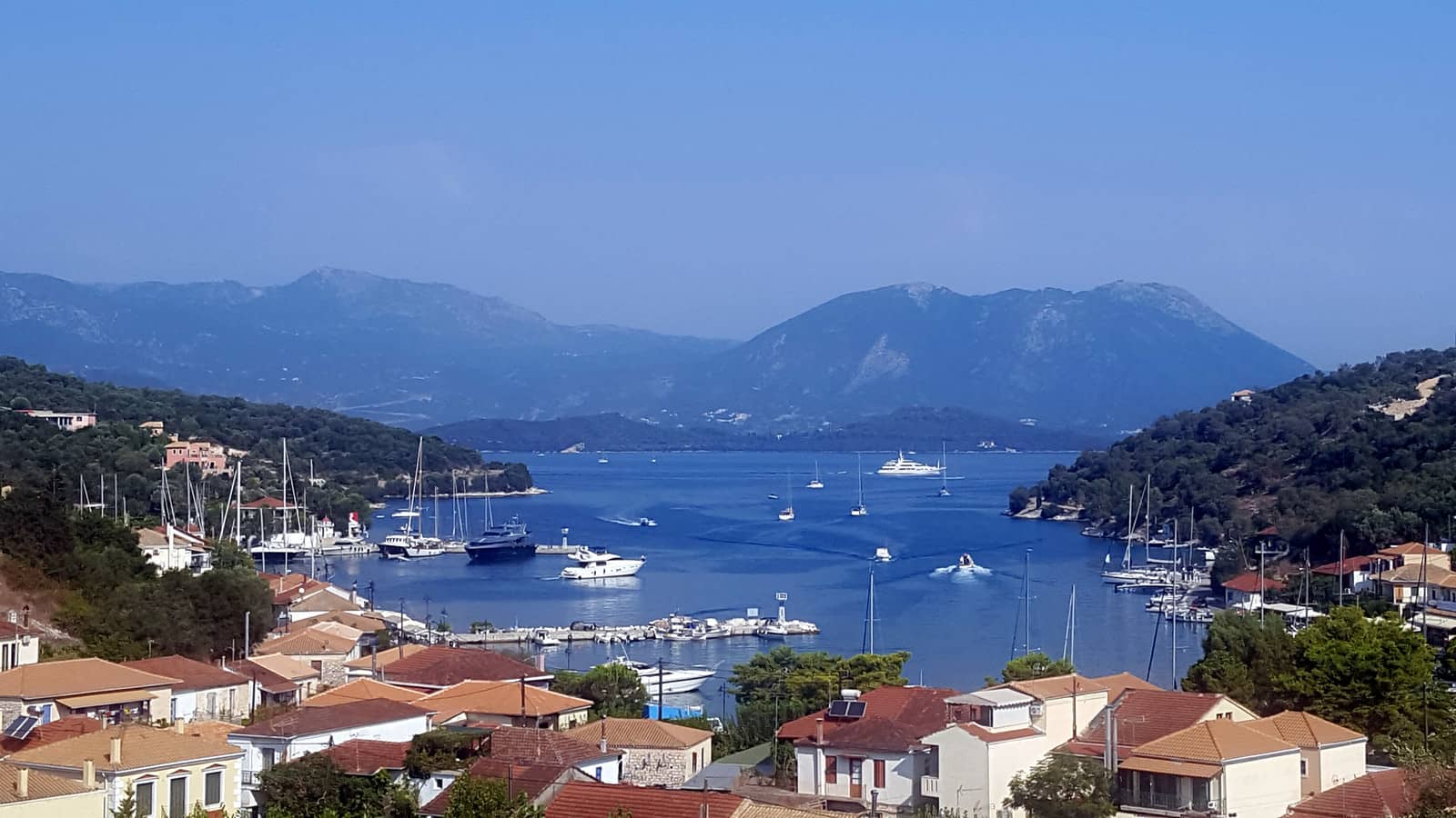
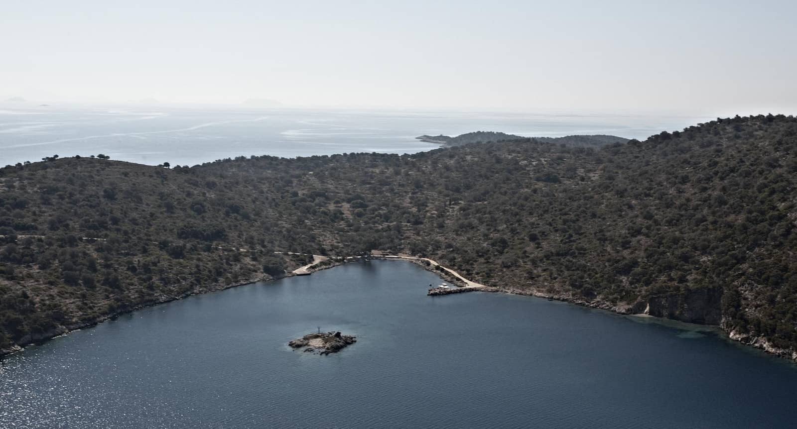
in the middle the islet of Madouri in front of Skorpios and Meganisi islands.
To the left is Sparti island and in the distance the mountainous mainland. Hi-res image
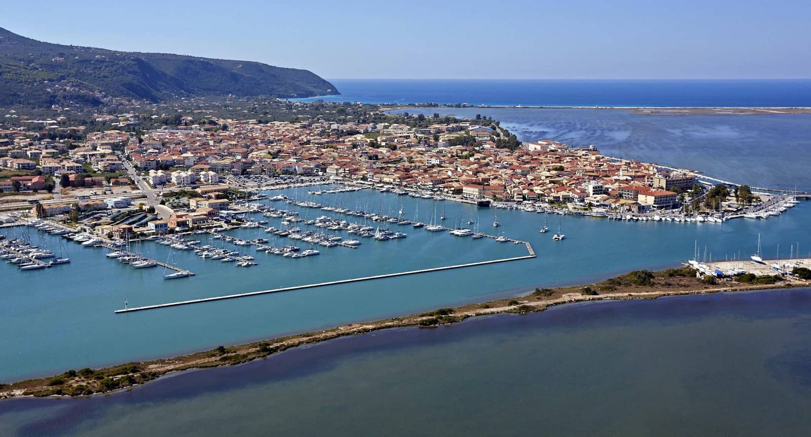
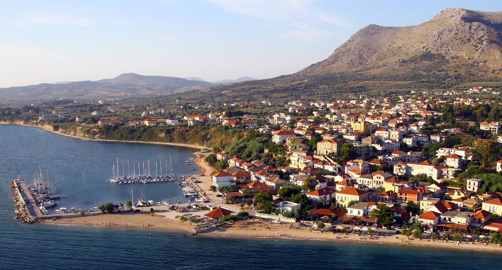
Lefkas city
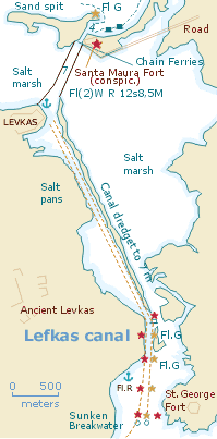
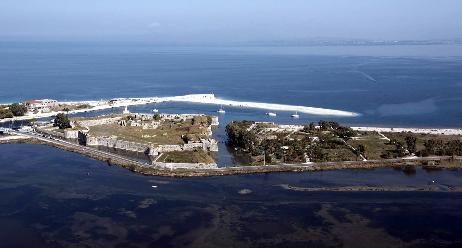
The approach of Léfkas / Lefkáda city - Πόλη της Λευκάδας from the north is rather challenging. The sandbank and silts at the northern end of the canal continuously change shape, and as of 2015 three groynes have been installed to protect the entrance, marked by 3 yellow buoys.
The next obstacle is the floating bridge: when both its ramps are raised and rotated towards the eastern shore it leaves an opening of 30 m wide. Officially the yachts going south have right of way, but the gap is wide enough for two-way traffic. See the bridge in action [Youtube], looking east.
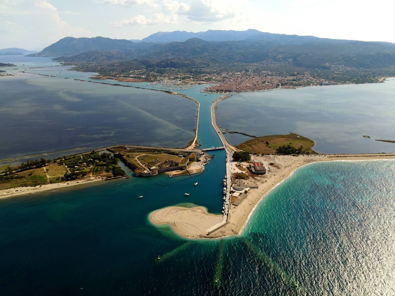
The groynes in the foreground, and the Santa Maura fortress on the left. In the distance Lefkas island and Lefkas town / marina. Note the closed floating bridge.
From 08.00 to 22.00 there is a full rotation of the bridge every hour.
From 23:00 to 07:00 the bridge also rotates fully, only if there is a ship, on request via VHF 12. Update 2026: due the new underwater pipeline project, opening times for yacht and vessels are temporally irregular; pipes will bring water directly from the mountains to Lefkada island.
Fun fact: the short older bridge is still there, just to the NE of the floating bridge.
On the north side there is a useful quay on the west side to dock (and stay for the night).
Once arrived at Lefkada you can go stern-to the quay. Note, that in several areas ballasting is sticking out use your dinghy as your own floating bridge and keep the yacht an extra 2 meters or so away from the quay. During visits in June 2022 (and spring 2024) we found even more pontoons: 7 now (reserved by the surge of charter fleets) protruding from small free quay section at the fun “Pirates Cafe” pointing towards the marina.
The second remaining section of quay that faces ESE is ideal in the prevailing NW winds, and should be an option for visiting yachts.
Be very careful when using your anchor, since there are several heavy chains for lazy-lines.
In easterlies opt for the marina.
Both Lefkas city (Lefkada) and Nydri are bases for yacht charters and 50 – 60 minute drive from Aktion National Airport.
Visit the Archaeological Museum of Lefkada, which highlights Dörpfeld's excavations and findings from Mycenaean – Roman times.
Three churches stand out: St Spyridon on the main square, St Nikolaos on the market and the nearby Pandokrator - Ιερός Ναός Παντοκράτορος.
The Ancient town Nirikos is difficult to find, but do attempt the 40 min southbound quest / walk hugging the canal. The settlement was abandoned in 1300, with continuous earthquakes scattering its traces. The ancient city was protected by a wall of 4.5 kilometers long, which the inhabitants had reinforced with rectangular towers. Some parts of the wall are still preserved, surrounded by arcadian fields and olive trees.
Further reading
- See chart symbols for the meaning of e.g.

- Mediterranean mooring and anchoring
- The sailing season
Winds • coastal effects • Lefkas and “Inland Sea”
Moving air takes the path of least resistance so where there is high land near the coast, it is deflected, funnelled and channelled according to the shape of the land. Greek coasts and islands are often steep-towith high mountain ranges climbing sharply out of the water. This particular topography means that a 20 knot breeze over flat water might be gusting off high land at 30 knots or more.
Wind blowing on to, or at an angle to, the coast will freshen close to the land. The land offers more resistance than the sea and where there are high cliffs or mountains the wind is simply blocked from blowing over the land.
Around a high headland or cape, the wind will follow the contours of the land. The compression of the wind against the land increases its strength, so inevitably you get gusts from different directions in these areas. The gusts push the sea from different directions and cause a confused sea around headlands so it will often pay to stand some distance off.
When the wind increases above a certain strength it may start to gust over the headland or cape, depending on the topography. On the windward side there will be light winds of variable direction where the wind has lifted, while on the leeward side there will be strong gusts, often 10 or 20 knots higher than the prevailing wind over the open sea. These winds – compressed and funnelled to take the easiest path over the lowest bit of land or down a valley – can lead to quite ferocious squalls on the lee side of capes and islands.
Where the wind blows into a channel or gap, say between islands, it will tend to follow the channel rather than blow across the land, and so it is channelled and speeded up. Moreover, it can can severely bend round into the channel.
Where a wind is establishing itself against an opposing wind there will be a buffer zone of variables in between, which can be several nautical miles or as little as 100 metres across.
In the
Ionian in Greece, the Maistro wind,
gets up around midday and blows consistently
at 10 – 25 knots from the north-west. In the
“inland sea” this wind can be deflected and funnelled
and channelled so it blows from the north, the
west and even from the south-west or south in places.
The chart below shows how the prevailing
wind is modified around Lefkas island.
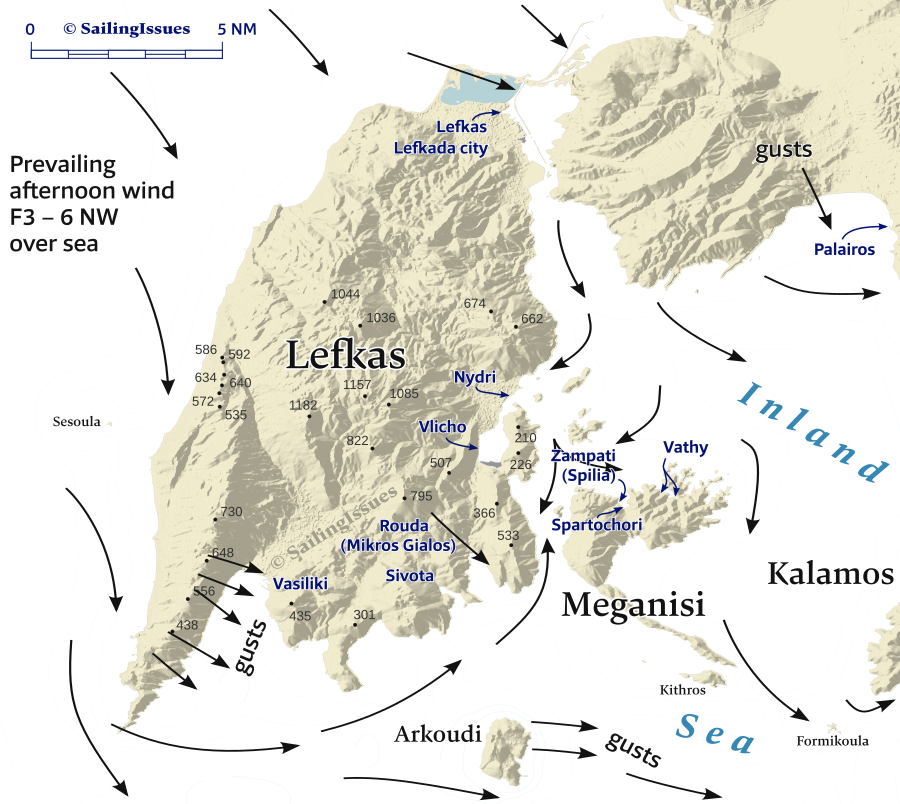
The lengths of these arrows are incidental.
Further east in the strait between Kastos and Kalamos islands you can expect similar funnelling conditions: either strong NE or strong SW winds.
Meganisi island
Off the south-east coast of Lefkas lies the sailor's paradise of Meganisi (meaning: “big island”, population ~1200, alt. 299 m) – the Homeric isle of Taphos – with a Chora, sandy beaches, fishing ports, sea caves, and a plethora of anchorages.
There is some farming land in the flatter western part of the island; the eastern part is occupied by a range of wooded hills interspersed with olive orchards accessible by walking trails leading all the way to the elongated southern Cape Kefali.
Zampati
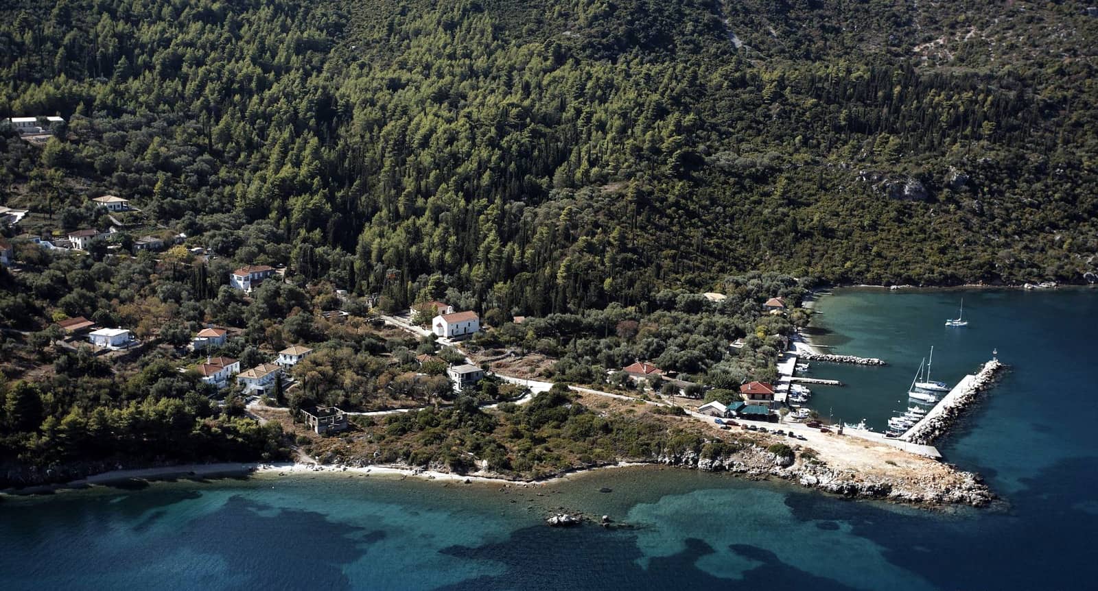
Zampáti - Ζαμπάτη is the first port in Spilia bay, which is ideal in all winds except NNE, in which case you should relocate to Spartochori, the second port in Spilia.
The seabed rises sharply, hence good holding when stern-to the quays. Prevailing winds are NW – N (and sporadically NE during the night) and the berths along the quay just west of the ferry are premium. Also the pontoons at “Panos and Babis” and the outside of the L-shaped fishing basin are popular. Predominantly laid moorings, we visited before the season and went alongside the L-shaped pier.
In town there is a statue of Marinos Zampatis, the hero who – in function as a coastguard officer – lost his life when fighting organized crime. The Nautical Club of Lefkada holds since 2011 an annual race in his honour.
For the best tavernas you will have to zigzag uphill to “Taverna Lakis” and “Summer Sun” in the Chora overlooking Zampati port.

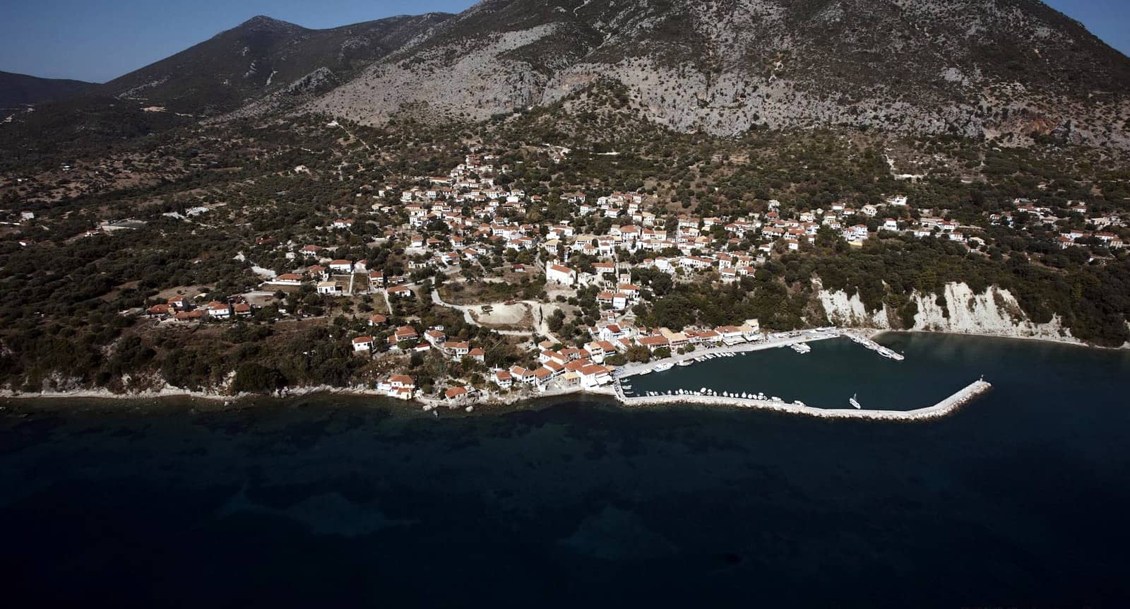
Spartochori
The nearby port of Spartochóri - Σπαρτοχώρι – also in Spilia bay, but further inside – is referred to as Spartachori in GWP.
A short section of the east quay can be used by visiting yachts, although most will have to moor at the SE quay, “Taverna Spilia”. The tiny mole (which is partly pontoon) for the fishing boats does not provide extra shelter and the prevailing NW – NNW winds blow right onto the SE quay. Fortunately good holding due to the steeply inclined seabed; some laid moorings, otherwise deep anchoring; yachts can go bows-to.
There are now 3 floating pontoons pointing NE which belong to Mr Babis, the owner of “Porto Spilia Taverna”, and he wants to add a fourth. The rest is municipal which means that you are not required to eat at his taverna even if he says so. At the quay next to the ferry to Nidri it is recommended to go bows-to, best shelter against the prevailing winds but you can expect a queue of lorries when the ferry is due.
Lazy lines installed!
Same restaurants apply as in Zampati. The Chora is very worthwhile and you should be heading in that direction anyway: marvellous views.
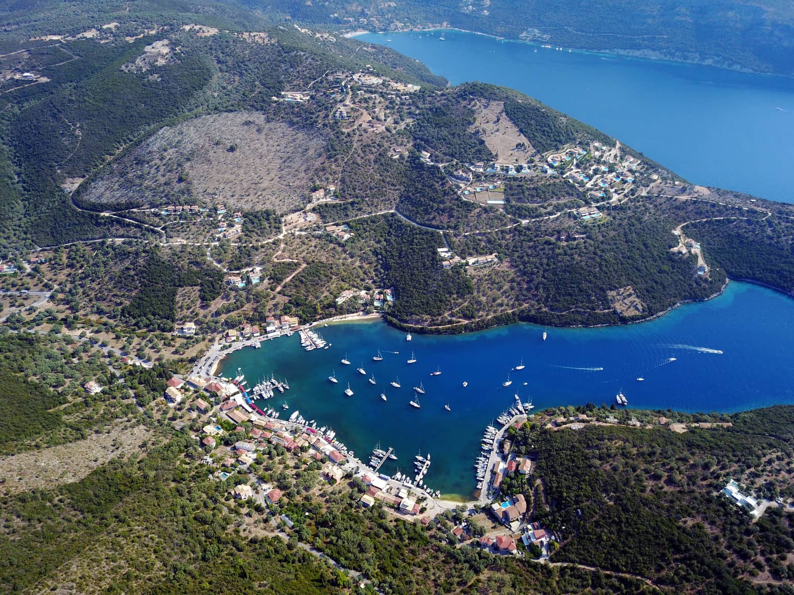
Vathy
Vathý - Βαθύ is the main ferry port of Meganisi and the deep Vathy bay offers several mooring options: the old harbour in the SE, the marina directly west and the short quay Lat Long at Taverna Karnagio - Καρνάγιο.
The old port and marina offer allround protection and – crucially – are ideal for the summer mistral / maestro conditions: the prevailing north-west winds. The electricity and water pillars are still not operational. Directly south is a lovely shady playground.
Although immensely crowded in summer the appealing Odyseas marina is rather the opposite of a typical concrete colourless marina.
In all but strong northerlies opt for the old harbour: less expensive and even more engaging, right at the town square and the superb Rose Garden Taverna.
There are shaded trails to the unspoilt village of Katoméri - Κατωμέρι, the “capital” of Meganisi.
Kapela bay
Kapelá - Καπελά is the bay directly east of Vathy and is branded Kapali bay in GWP. There are four anchorages in weed / sand: one at the head of the bay, two deeper spots in the west coves and one in the east cove.
Ambelakia bay
The trifurcate Ambelákia - Αμπελάκια or Abelike bay further east offers at least 3 commodious yet often crowded coves. The south-easternmost spot (with a line to the north shore) is superior; there are some new fancy shiny buildings with landshaping; amble to the Vathy town square (once you find the track, see openstreetmap).
Atherinos
 The bay and modest port of Atherinós - Αθερινός, also known as Atheni, is open to the N – NE. Go stern-to or along-side the quay on the outside of the pier. Limited provisions, but lots of fresh fish and a few taverna.
The islet of Micro Nisopoula lies within the white sector of the lighthouse of Cape Elia.
There are several anchorages, notably to the north of the infamous reef Lat Long by preference place your anchor in deep water and take a line ashore.
Also sail to the sea caves of Papanikolis Lat Long – where the homonymous submarine took cover during World War II – and Giováni Lat Long.
Mainland Greece
Varko
Opposite Lefkas island – in the east approach of the canal – is Varkó - Βαρκό bay guarded by the wooded islet of Agios Nikolaos.
To avoid the various reefs, extending from capes, steer towards the islet from open waters.
Good holding in sand and protected against the northwesterlies. The middle stretch along the north-west shore is riddled with shoals, anchor at either beach or, more adventurous: take a line ashore Lat Long.
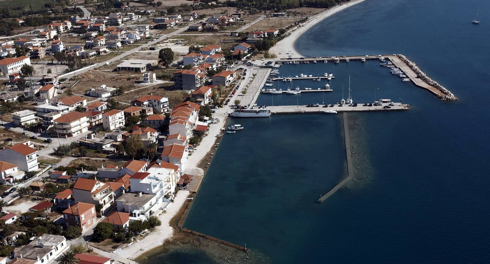
Palairos
The delightful village and port of Pálairos - Πάλαιρος offers allround protection.
In the afternoon the prevailing wind is WNW, veering to a nightly – possibly stronger – ENE flowing down from the formidable Acarnanian mountains.
A super restaurant is a short distance from the waterfront: enjoy the walk to, and the crawl back from “The new mill taverna”; vincitori ex aequo are “SIRTAKI” (young Dutch owner George) which has his own pontoon installed since April 2026, and Panorama / Πανόραμα for Indian dishes.
In most berths there is solid holding in mud, but be sure that the anchor holds, luckily nearly everywhere lazy lines are installed. A large flotilla fleet operates out of Palairos: all amenities available. In an emergency the charter marina Vounaki further south can be used
Ancient Palairos is 11 km (25 min. by taxi, a 2 hr. hike) to the north-west, where you can spend a whole day exploring all kinds of ancient treasures.
In the first year of the Peloponnesian War (431 BCE) Palairos was in alliance with the Athenians; and when the latter conquered the neighbouring town of Sollium – a Corinthian colony – Athens handed Sollium plus its territory to the inhabitants of Palairos.
Palairos existed at least as early as the 6th c. BCE, but reached its zenith in the 3rd c. BCE.
In 31 / 30 BCE, after the Battle of Aktion and the foundation of Nikopolis by Octavian Augustus the city must have been abandoned, since all the inhabitants of Acarnania and Epirus were forcibly moved to Nikopolis.
The city walls present one of the most extraordinary examples of defensive architecture in western Greece, still standing in their original height. It is ca. 2 km long, enclosing the city center and terminating in an acropolis on top of the hill. The city also spreads outside of the fortification, where a large number of ancient house ruins can be seen.
The part of the walls that use the polygonal system date to the 5th c. BCE, and most of the rest of the fortification covers the time span of the end of the 4th c. BCE. At some sections the wall is reminiscent of cyclopean construction. Stairs leading to the battlements still stand and can be used even today.
Six towers were built next to the 7 gates, the best preserved ones are the (central) north gate and the vaulted north-western gate or “harbour gate”.
Visible house remains show a unified city plan organized in the Hippodamian system. The ancient agora and likely stoa are on the northern part of the plateau.
Mytikas
Mýtikas or Mýtika - Μύτικας on the mainland is a non-touristy working place.
The unfinished breakwaters of the 2nd basin are now overall below sea level. In the larger basin there is good shelter aside from the SSW winds; few available berths.
Kalamos island
Episkopi
Episkopí - Επισκοπή is a rather shallow and isolated port on the north coast of Kalamos. Closer to the entrance there are sufficient depths – smaller yachts can dock in further inside. The port is unsuitable in westerlies and stronger easterlies; the foliage combines amazingly with the cerulean waters.
Along the coast farther east there are several (lunch-stop) anchorages (and small piers to tie a line to), notably at the monastery and at the Ayios Donatos church.
Kalamos port
The port of Kálamos - Κάλαμος is surrounded by magnificent woods, while higher up the more barren hills are visible, since these rise up to a steep 754 m. There is allround protection except from a strong Sirocco (SE) that could occur in early spring. The quay was strenghtened with new pavement and wave-dissipating blocks in 2025. Although there is a garbage container, this is no longer meant for passing boats since the flotillas took advantage.
Eagleray, Garmin and C-Map mention a reef 045° and 780 m from the light, 100 m from the coast. Also C-Map shows a stone awash directly east from the port.
Go stern-to the quay or the breakwater, yet go bows-to where there are protruding blocks, i.e. the concave section where anchor spaghetti is guarenteed. Near the extremity boats go alongside (and will raft up). No water and electricity in port. George from George's restaurant controls the port and who will add as much boats as possible. His restaurant also offers three small showers at 3€, 2 WCs, a washing machine at 6€.
During the night there can be (severe) gusts from NW – NE.
The prevailing SW winds become stronger in the afternoon.
Synoptic westerlies become southerlies in the Kalamos strait. Furthermore, this strait is notorious for its violent gusts when the north-westerlies blow.
The local George is both a knowledgeable assistant when docking your yacht and a larrikin: he figures himself King Kalamos.
The pine trees of Kalamos are precious and home to many species of birds – the only other forests of this type are found on the Northern Sporades.
Kefali / Gerolimnionas
Kefalí - Κεφαλί also known as Gerolimniónas - Γερολιμνιωνας is a lovely bay on the south-east coast of Kalamos. The village of Kefali, known in earlier days by its Venetian name “Porto Leone”, was abandoned following the 1953 Ionian earthquake.
Note, that the Port Leone Bar is out of business; the jetty is now private; on 30 June and 15 August pilgrims visit the church.
Anchor at the north or south beaches, or rather – my favourite – east of the two derelict windmils; good holding, aquamarine water.
See Greek chart terms.
Schinas
Schinás - Σχοινάς is a tiny wonderful collapse cave, hence the low but vertical cliffs, located on the south tip of Kalamos; anchor in 5 – 10 m; quite a lot of weed; crystal clear water; difficult for the night; fits two vessels.
Kastos island
Kastos port
Kastos is a low-lying island – the hills peak at just 143 m – generally barren, yet with some fertile cultivated areas: figs, opuntia and very old olive trees. Since there are only a few roads the islanders travel by boat.
When approaching the port of Kastos - Κάστος on the south cape you will see the conspicious windmill that now hosts a cocktail bar.
Go stern-to the breakwater inside the basin or anchor and take a long line to the west or north beaches.
In westerlies go stern-to the breakwater on the outside, keep at least 10 m out.
The northern breakwater is rarely used but room for one yacht to go alongside or more when rafting up, depths are ~2 m at the tip; your bow should point north!
Poor holding and only solid shelter in SE – S – NE winds. Setting a second anchor is advised. Katabatic gusts from the mainland flowing down from the NE, but the breakwater will still offers the premium berths yet only 9 monohulls will fit. Keep clear of ±10 m end, marked in yellow and black. In SSW winds the port can become untenable.
The small water taxi (Kastos to Mytikas) docks close to the entrance of the fishing port, alternatively you can anchor and take a line to the south quay, see how to do it. Tavernas open in the summer.
You cannot land garbage, and there is no water or power supply, no facilities, but mooring is free of charge…
Sarakiniko
Sarakíniko - Σαρακίνικο is a very secluded bay apparently appreciated by the Saracen who found refuge here Lat Long. The toponym is quite common, e.g. on Ithaca island, Syros island, Milos island or Parga.
Anchor in 4 – 6 m; there is a short breakwater to tie a line to; catamarans can go alongside; no facilities, but a 15 min. walk to Kastos port.